![Chinatown, East Hastings, Blood Alley [Walk sign]](/uploads/r/null/2/d/1/2d1760cb1adf89cb2c06a7f5253eb157b681b3ea8f7723cc1eab9829c120652d/64943228-8899-49cd-ae51-0fba1d0bc82f-CVA1095-08784_142.jpg)
Chinatown, East Hastings, Blood Alley [Walk sign]
- COV-S644-: CVA 1095-08784
- Item
- Sept. 1968
Part of City of Vancouver fonds
23 results with digital objects Show results with digital objects
Chinatown, East Hastings, Blood Alley [Walk sign]
Part of City of Vancouver fonds
![Naval parade and review [Cambie and West Hastings]](/uploads/r/null/6/e/6eb34cc2d7a336262d8897a793cc11faface3f399fd4d32b966507b117f84be3/6bd11750-ca63-4a9a-8a15-997e4ab35d60-A00552_142.jpg)
Naval parade and review [Cambie and West Hastings]
Part of Stuart Thomson fonds
![Canadian Traffic Signal Corporation - For Mr. Hampson [Closeup of signal]](/uploads/r/null/8/7/5/87554d852146ef34588d2bcafc2b41f414f318f4331b2f7ad5fb335069612bb3/ea42c7cd-19ec-494e-a920-c808bc0415ef-CVA99-6630_142.jpg)
Canadian Traffic Signal Corporation - For Mr. Hampson [Closeup of signal]
Part of Stuart Thomson fonds

Part of Stuart Thomson fonds

Municipality of South Vancouver
Part of City of Vancouver Archives technical and cartographic drawing collection
Item is a map sheet; the main map shows District Lots, blocks and lots, street addresses, schools, and a cemetery. The inset map shows electric streetcar lines in from Vancouver to New Westminster.

Transit routes in downtown area Vancouver, B.C. effective July 18, 1952
Part of City of Vancouver Archives technical and cartographic drawing collection
Item is a sheet which contains maps of the downtown portions of 14 BC Electric transit routes: Dunbar, Arbutus, Granville - Kingsway - Victoria, Macdonald, 4th Ave. - West Pt. Grey, Powell - Stanley Park, Broadway East - Robson, Hastings East, Main, Davie - Fraser, Grandview, Oak, Cambie, North Vancouver - Intercity.

Railroad tracks by Lamey's Mill Rd.
Photograph taken facing east. Hemlock on-ramp to Granville Street Bridge visible on left of photograph. unidentified apartment buildings visible in background.

Canadian Traffic Signal Corporation - Photo of New Signals
Part of Stuart Thomson fonds
Photograph shows Marine Drive at Heywood Park

Canadian Traffic Signal Corporation - Photo of New Signals
Part of Stuart Thomson fonds

Canadian Traffic Signal Corporation - Photo of New Signals
Part of Stuart Thomson fonds
Photograph shows the intersection of Granville Street and King Edward Avenue

Canadian Traffic Signal Corporation - Photo of New Signals
Part of Stuart Thomson fonds

Canadian Traffic Signal Corporation - Photo of New Signals
Part of Stuart Thomson fonds
Photograph shows the intersection of Granville Street and King Edward Avenue

Map of Stanley Park, Vancouver, B.C.
Part of City of Vancouver Archives technical and cartographic drawing collection
Map verso is a drawing in pencil of a circle around the letter 'K', with a hand-written description of the flowers chosen to create the arrangement, the number of flower bulbs needed, and their prices. Also shows the City of Vancouver crest and publisher information.

Map of Stanley Park, Vancouver, B.C.
Part of City of Vancouver Archives technical and cartographic drawing collection
Map shows roads, trails, horse trails, street railways, beaches and buildings in Stanley Park. There is a drawing in pencil on verso of a circle around the letter 'K', with a description of the flowers chosen to create the arrangement, the number of flower bulbs needed, and their prices.
Map of Stanley Park, Vancouver, B.C.
Part of City of Vancouver Archives technical and cartographic drawing collection
Map of Stanley Park, Vancouver, B.C.
Part of City of Vancouver Archives technical and cartographic drawing collection
Map shows roads, trails, horse trails, street railways, beaches and buildings in Stanley Park.

Map of Stanley Park, Vancouver, B.C.
Part of City of Vancouver Archives technical and cartographic drawing collection
Map of Stanley Park, verso.
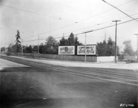
Kingsway at Knight Street, southeast corner, post improvements
Item is a photograph of the intersection of Kingsway and Knight Street, looking at the southeast corner, after the Kingsway improvements. The photograph shows the widened section of Kingsway and the fully renovated fence and sidewalk sections across Knight Street. New billboards on Knight Street have advertisements for Forst's Radio (selling Philco radios) and City Coal Co.
![Lighting [24 of 47]](/uploads/r/null/2/7/27dbc5dcd2023813798b34042c580b9c330a91094da6796cfc9df5f984219407/3f9e71e8-5c15-4a55-af52-d27c4a3f5caa-A66186_142.jpg)
Part of City of Vancouver fonds
![Streets [110 of 139]](/uploads/r/null/f/4/f492232e391faa24a46f0576637d2212c9c20a9f3ee5a52e1027f165144cf797/89072e68-5e4b-4dde-8fa2-fb4386b16096-A64353_142.jpg)
Part of City of Vancouver fonds

Plan of the City of Vancouver, B.C.
Part of City of Vancouver Archives technical and cartographic drawing collection
Item is a map which shows city lots and blocks, with street car lines, postal block numbers, and district names shown in red.
![[Mrs. Quiney with Theresa, James, Ken and Rose in the snow at Pender Street and Ingleton Avenue.]](/uploads/r/null/8/8/880ae2d7d8c0779914dab1dd1617f3325e9ba99e4163a52cff1ff2720831d12f/4f0436d8-b192-47d3-b975-5629166b5475-A20317_142.jpg)
[Mrs. Quiney with Theresa, James, Ken and Rose in the snow at Pender Street and Ingleton Avenue.]
Part of James Luke Quiney fonds
![[Central building] Alley View](/uploads/r/null/d/4/d4feaae4c73f69c4ac7613698edeecba9f3e9a268c6b5d5e56387ec875ff1526/d82ff3f9-5dd9-4d44-b8a0-7d0e0f8fc307-CVA810-32_142.jpg)
Photograph shows the Alley behind the Central building on Abbott Street. Photograph also shows parked cars, streets signs and pedestrians.
![Building [Guichon Block] at 401-407 Columbia St. and Burr Block at 413-419 Columbia St., New West...](/uploads/r/null/7/f/7f39dbe26da177522375483a1a4a924622161f244e705d7884770f46dafa4b38/8a1a3876-8d57-466e-92fd-397404b27cb4-CVA810-29_142.jpg)
Photograph shows the Burr and Guichon blocks on Columbia Street in New Westminster from the intersection of Columbia St. and 4th Street. Street, sidewalk, cars and pedestrians also shown.

The Cloth Hall at 365 West Cordova St. Entrance, Vancouver
Photograph shows Cloth Hall on the W. Cordova St. entrance side. Street, sidewalk and parked cars also shown. The Matoff building is shown to the right of Cloth Hall. Businesses shown include Jeeves and Stewart Agencies. The Homer St. street sign is visible in the foreground.