![[View of East Pender Street at night]](/uploads/r/null/7/4/74ecbde63e3b15ee111f752cc895b59d5ee6630cac77ae06770c70d47789c874/f5ee10f4-9215-4ece-8efc-26a986c27303-A59340_142.jpg)
[View of East Pender Street at night]
- COV-S511---: CVA 780-475
- Item
- [between 1960-1980]
Part of City of Vancouver fonds
Photograph also shows the neon Ho-Ho Chop Suey Restaurant sign (102 East Pender Street)
[View of East Pender Street at night]
Part of City of Vancouver fonds
Photograph also shows the neon Ho-Ho Chop Suey Restaurant sign (102 East Pender Street)
![[Aerial view of Mount Pleasant, South Strathcona and Kensington-Cedar Cottage]](/uploads/r/null/7/5/75ea991fe8319eaffda79b314cbf20e281e35eb2cd8a89eaa898b492242d6282/05f856f3-0a45-41eb-94dc-46cb9d2f7ecf-A63348_142.jpg)
[Aerial view of Mount Pleasant, South Strathcona and Kensington-Cedar Cottage]
Part of Major Matthews collection
Photograph shows aerial view of the east end of False Creek, Thornton Park, Great Northern Railway and Canadian National Railway yards, Mount Pleasant, Strathcona, Grandview-Woodland, Trout Lake, Kingsway, Vancouver Technical School grounds, Renfrew playing fields, John Hendry Park, British Columbia Electric Railway Right of Way, Clark Park, Grandview Highway South, Great Northern Railway.
![[Cottages in the 200 block of Prior Street]](/uploads/r/null/6/f/6fbc5f42d07ed85e4d0089daa6235ff32bb273ccf5699745c6257ed458291e46/aa002878-4e76-4fc4-a89e-db0fb7ce4387-A09980_142.jpg)
[Cottages in the 200 block of Prior Street]
Part of Major Matthews collection
J.S. Matthews' notes with print or negative in Archives. Photograph shows 217 Prior Street, 221 Prior Street and 225 Prior Street.

Part of City of Vancouver fonds
Map is an identification plan for Redevelopment Project 1, Area A-1, showing boundaries of clearance areas in Strathcona and ownership of property included in the acquisition program. Base map is bounded by Main Street, Glen Drive, Alexander Street, and Atlantic Street, and shows streets, legal descriptions, schools, parks and Canadian Pacific and Canadian National railway lines.
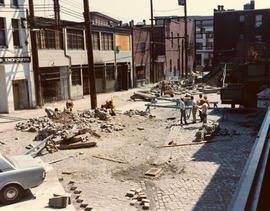
![Pouring new sidewalk in the 500 block Pender [East Pender and Jackson Streets]](/uploads/r/null/d/b/db1415cb55bee86833fe0bd3e647fa4dbf07091fdcf7392a3f6078165ec5f6a1/77694c80-ee6e-405e-be26-2a846fc26eb7-A59235_142.jpg)
Pouring new sidewalk in the 500 block Pender [East Pender and Jackson Streets]
Part of City of Vancouver fonds
Photograph also shows houses and buildings including the dome of the Sun Tower (100 West Pender Street)
![[Houses in Strathcona, Vancouver]](/uploads/r/null/a/0/a005eb5c4ed20130550fa2b0c87b7866eeb2e629dd57607db4ddf2be9aeec169/26b64878-3f88-4812-9e49-805eb40dc671-A63200_142.jpg)
[Houses in Strathcona, Vancouver]
Part of Barbara Wilson fonds
![[Houses in Strathcona, Vancouver, B.C.]](/uploads/r/null/3/5/35835ee63982b98efa1962d90fe47ba445f9bc6e1ba38dd9cb982551c082de7b/dffaf431-c29d-4e8a-a6f3-35f4bd5dda74-A63198_142.jpg)
[Houses in Strathcona, Vancouver, B.C.]
Part of Barbara Wilson fonds

N.E. Corner Gore Avenue and Pender Street
Part of Walter E. Frost fonds
Photograph shows the Pender and Gore Garage and the Vasa Rooms.
Blood Alley and Trounce Alley during construction
Part of City of Vancouver fonds

Blood Alley and Trounce Alley prior to construction
Part of City of Vancouver fonds

Blood Alley and Trounce Alley prior to construction
Part of City of Vancouver fonds
![Vancouver, B.C. from Mt. Pleasant (Panorama view) [from Scotia Street and Sixth Avenue]](/uploads/r/null/7/2/72b78a8eafd51df2fbf51d5827543e2e56d582516dc35b844563392b9d5f2ca4/605b2909-96fb-483b-b5b7-d3665dd80ae3-A26630_142.jpg)
Vancouver, B.C. from Mt. Pleasant (Panorama view) [from Scotia Street and Sixth Avenue]
Part of Major Matthews collection
Photograph shows a view of Strathcona and Strathcona School across False Creek from Mount Pleasant.
![[View of "old" (ca 1904?) one storey house at 436 Union Street]](/uploads/r/null/7/e/7e4cc99f56f2209f1ea12a8a43b4d9aa0414c0fc51f0f10ee95e10da3cccc24d/d798aeee-7a4f-4d6a-8931-a0891829c9eb-A47157_142.jpg)
[View of "old" (ca 1904?) one storey house at 436 Union Street]
Part of City of Vancouver fonds

McDonald Cedar Products (piers G17 to G19)
Part of City of Vancouver fonds
![224 Union Street [front]](/uploads/r/null/d/f/df35dc4c9428ee2a86be4bf2c8bc1874c16521e8c8b1760bff20603e23b43b0d/ce7f3a1d-ea97-4cd3-a892-9a3ffb6eab35-A59031_142.jpg)
Part of City of Vancouver fonds
Photograph also shows portion of 218 Union Street.
![224 Union Street [back]](/uploads/r/null/0/9/097cf00086d2c3783c04485d0c3d9a3c8d658e3cbd8531ac48817ebf394a3b4e/fa680b57-04cd-4a33-b83d-6fb093403d87-A59032_142.jpg)
Part of City of Vancouver fonds
Photograph also shows portion of 218 Union Street.
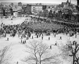
May Day demonstration crowds at Powell Street grounds
Part of Stuart Thomson fonds

May Day demonstration crowds at Powell Street grounds
Part of Stuart Thomson fonds
![Japanese Hall [475 Alexander Street]](/uploads/r/null/8/9/891e0a1f2f28fb242719bfea6b4186c69367f534dbd5d5af1e415d3f98f07426/f0b1b862-10a7-41bc-9eff-0bac016fbce3-A01135_142.jpg)
Japanese Hall [475 Alexander Street]
Part of Stuart Thomson fonds
![[300 block] Powell Street](/uploads/r/null/2/8/28e944f25ee27abe68690e3f295033e816cdce0ee81ab5b8856eb5c1f641a346/e5d1d846-d604-473a-b857-7bf4aca8fef2-A01785_142.jpg)
Part of Stuart Thomson fonds
![[200 block Powell Street]](/uploads/r/null/7/2/72ddce73c4629ca1b7eabc1b2f06197f43faf940c3dad56513a234fb46396ef3/60ab6797-c9bc-4aa5-a118-d06006847bcd-A01131_142.jpg)
Part of Stuart Thomson fonds
![Shipment of new trucks [parked on the south side of Prior Street at Gore Avenue]](/uploads/r/null/b/6/b61b426307cbb3b2923d69af51c121cc0c8ec6223df22c244ea809f5f99f68d4/bc23df63-267f-4c12-8a5e-00a4bdd1ed0e-A17681_142.jpg)
Shipment of new trucks [parked on the south side of Prior Street at Gore Avenue]
Part of Stuart Thomson fonds
Photograph shows buildings and houses in the 200 and 300 block of Prior Street. Buildings promient in photograph are: Sun Tower, Pacific Iron Works, and the Stratford Hotel. Also shown are the smoke stacks of B.C.E.R. Ltd.
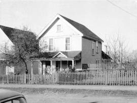
View of "old" (ca 1909?) one storey house at 563 East 7th Avenue
Part of City of Vancouver fonds
![[View of Malkin Wholesale Cash & Carry (750 Malkin Avenue) from Prior Street]](/uploads/r/null/9/6/969f1e392eb3b1659e86774eb23e7d89836d15addfa1d69db55c222db28a2e2c/29d7ac7a-e2fa-4d42-8b7e-5349721aa0a5-A59072_142.jpg)
[View of Malkin Wholesale Cash & Carry (750 Malkin Avenue) from Prior Street]
Part of City of Vancouver fonds
![[View of the 700 block Prior Street] from Malkin St [Avenue]](/uploads/r/null/0/6/060f8de30163254502b972a96016bb94d78d8d1689b21d73dc2394f1dd1be8d8/57d3834c-c497-472a-823e-5b20842664d7-A59071_142.jpg)
[View of the 700 block Prior Street] from Malkin St [Avenue]
Part of City of Vancouver fonds
Photograph shows the Irish Hall building and two row houses in the 800 block Hawkes Avenue.
![[Western Assembly Ltd. shed, 94 West Pender Street (rear)]](/uploads/r/null/3/4/34b5f4a263d5c309c616cd7d2abf02376fe515fe00ed297748ea44a85c0afe32/f4855238-e473-44d7-906f-3e3f59095040-A59070_142.jpg)
[Western Assembly Ltd. shed, 94 West Pender Street (rear)]
Part of City of Vancouver fonds
![[Western Assembly Ltd. shed, 94 West Pender Street (rear)]](/uploads/r/null/d/b/db46d229e885b574fe44a0193e9d777d0792c46d57682de856e13ba32bf45e4d/1767a6e9-7f65-4f77-81b6-ebc77b4957b6-A59069_142.jpg)
[Western Assembly Ltd. shed, 94 West Pender Street (rear)]
Part of City of Vancouver fonds
![[Western Assembly Ltd. shed, 94 West Pender Street (rear)]](/uploads/r/null/3/c/3ca1db079afe7c07ccfa546c35347701684943b72b522684e4ab0c854ff0c578/a8086357-3f3f-4d5e-88a4-2766da433b51-A59068_142.jpg)
[Western Assembly Ltd. shed, 94 West Pender Street (rear)]
Part of City of Vancouver fonds
![[Western Assembly Ltd. shed, 94 West Pender Street (rear)]](/uploads/r/null/4/9/492ec4de27318ded629f59e34564bfa87aa272ead8ce13c616f8f77d56ac7e6c/1fe45c06-61c0-4e6a-951d-bdbe60ae8815-A59067_142.jpg)
[Western Assembly Ltd. shed, 94 West Pender Street (rear)]
Part of City of Vancouver fonds
![[Western Assembly Ltd. shed, 94 West Pender Street (rear)]](/uploads/r/null/f/9/f95f7aba035edf4d5afeb10c133ce3cdd0f7a4521fcdaaa5290bcbc76dbeb60d/4046eb74-bce3-4733-9056-7b8fa52b0d34-A59066_142.jpg)
[Western Assembly Ltd. shed, 94 West Pender Street (rear)]
Part of City of Vancouver fonds
![[Houses at] 278 [Union Street] and 809 Gore [Avenue]](/uploads/r/null/6/4/64100bb23754f1e398e2ba851c15151df6597728236eb8348ffe43b6b2e1704f/b914e1c0-496d-4c85-83e1-0bfa9ce31e90-A59054_142.jpg)
[Houses at] 278 [Union Street] and 809 Gore [Avenue]
Part of City of Vancouver fonds
![278 [Union Street] and 809 Gore [Avenue]](/uploads/r/null/f/2/f2d750c74c5cf9bf8e35772174a40307d44f5b23740d3067dcb4fde18dbc1b10/61091604-3c93-4573-b62a-ba6bf430080a-A59053_142.jpg)
278 [Union Street] and 809 Gore [Avenue]
Part of City of Vancouver fonds
Photograph shows the house at 278 Union Street beside the Union Laundry building.
![274 [- 278] Union Street [back]](/uploads/r/null/c/2/c2a21a6ac3bdc852dceae73b99abf16d7a11a98d0d50bd40b0222aba0dda72ee/7cb78922-e1cd-4859-8402-6b324349f3b4-A59052_142.jpg)
274 [- 278] Union Street [back]
Part of City of Vancouver fonds
Photograph shows Union Laundry and portion of a house (back of 278 Union Street)
![274 [- 278] Union Street [back]](/uploads/r/null/7/c/7c42905e45c4d270d410b06ba114b4a0ada5f1f8d390704ba0bc357a3ce4e667/89f2d94d-0e0e-40d0-9d3a-effa5281d2c9-A59051_142.jpg)
274 [- 278] Union Street [back]
Part of City of Vancouver fonds
Photograph shows Union Laundry and portion of a house (back of 278 Union Street)
![274 [- 278] Union Street](/uploads/r/null/2/a/2a32fe68b960f24670d63b83674dba87aab2dcf887b7e164c7202860c9180f5b/bc5b0c1d-d81f-48ef-9500-69083b3e5da7-A59050_142.jpg)
Part of City of Vancouver fonds
Photograph shows the Union Laundry.

McDonald Cedar Products (piers G17 to G19)
Part of City of Vancouver fonds
![[219 and] 221 Prior Street](/uploads/r/null/c/d/cd282c2bf7b2f0067fa876724b323da0f28efab180af2a1e6e5ff4889fa7a07b/6913f428-7a6b-4ed7-baa8-d2a0dc3d6467-A59049_142.jpg)
Part of City of Vancouver fonds
Photograph shows the Iberica Garage and the Northland Cafe
![[219 and] 221 Prior Street [back view of the Iberica Garage and the Northland Cafe]](/uploads/r/null/2/2/2222e00535a17f88b2e1e591a9bae8c13d37d8ded5391080a8f0316afd4edd3a/2757dd36-2905-42d4-a78c-173cfc9a3e22-A59048_142.jpg)
[219 and] 221 Prior Street [back view of the Iberica Garage and the Northland Cafe]
Part of City of Vancouver fonds
![[219 and] 221 Prior Street](/uploads/r/null/1/6/16519d39f4c06087f60b1270989ec7b655ab61d7a350c02f2eb1546580b0d0ea/bb4e4d5f-e46e-4f9a-bbfd-c58be37656de-A59047_142.jpg)
Part of City of Vancouver fonds
Photograph shows the Iberica Garage and the Northland Cafe
![[219 and] 221 Prior Street](/uploads/r/null/b/0/b045e3b739fb000f7ef729743a67e781a07dc8a74ba86808e23fc0db4f7aed18/d597b9dd-ddf4-4c9d-8494-c98bc24b1cc2-A59046_142.jpg)
Part of City of Vancouver fonds
Photograph shows the Iberica Garage and the Northland Cafe
![268 Union Street [back]](/uploads/r/null/d/a/da4e577f98174c2b86be5e032a4ccf3fe064502a6758f0f8ee70ce197045de5f/420ecb80-31f4-4b0d-94cd-1bc8fb27f976-A59045_142.jpg)
Part of City of Vancouver fonds
![268 Union Street [front]](/uploads/r/null/0/5/05f4c917e1d95c94bcd38884486b0940ea885c83a16fbed43294743f3ae27848/95875d26-b6d8-4d3c-91c3-19a59253b64e-A59044_142.jpg)
Part of City of Vancouver fonds
Photograph also shows part of 264 Union Street.
![264 Union Street [back]](/uploads/r/null/9/9/9935f4334716951d5ed0bc666d6a317c0c061ac36a1417f37a957d580a437e94/a76d26d0-1b8d-4972-adf2-db9f7fe6215f-A59043_142.jpg)
Part of City of Vancouver fonds
Photograph also shows part of 268 Union Street.
![264 Union Street [front]](/uploads/r/null/b/3/b3478c612ceb9d033b16ed09e2f52a1dd8f2cb29520e9cc4ad527a9d217b189b/01e220c4-d656-4042-8d3a-69114b290c7d-A59042_142.jpg)
Part of City of Vancouver fonds
Photograph also shows part of 268 Union Street.
![248 - 250 Union Street [back]](/uploads/r/null/6/8/6878317981fc4c7a7f88c0e38e170f7c92a595c750254e7d90592673460b9b94/0b0628d7-c302-4b9c-9774-3f8b166036f2-A59041_142.jpg)
Part of City of Vancouver fonds
![248 - 250 Union Street [front]](/uploads/r/null/0/1/014d1dc53b6ed6f8358925afb23cee24e67b65abc293bfe4d445432f1b46aa60/9de497b0-7ec7-4ce4-b5b2-b5a460572ad4-A59040_142.jpg)
248 - 250 Union Street [front]
Part of City of Vancouver fonds
![232 - 240 Union Street [back]](/uploads/r/null/6/a/6abdd8c0df7eef2791f10604d7bc4fe7f4bdd3bf6a1ce0815b396946dff5e571/c8cd339c-176d-4b23-8e3b-99c3c6a61d6b-A59039_142.jpg)
Part of City of Vancouver fonds
![232 - 240 Union Street [side]](/uploads/r/null/9/f/9ff42823536998ba27491ddc8ac04cdd24b238ed944676610fae1c425fe3dcca/faa05030-f30b-4f4d-be78-fd84e3907bc4-A59038_142.jpg)
Part of City of Vancouver fonds
![232 - 240 Union Street [back]](/uploads/r/null/6/5/659652b7a7c6c9e0139216f862bf807df9780db9286f022f92687b848b649504/1956001c-e131-4398-8fee-5e64cd2c0deb-A59037_142.jpg)
Part of City of Vancouver fonds
![232 - 240 Union Street [front]](/uploads/r/null/a/8/a8e93b5ce717c60a3fb028fd1a385a2a949f2d0886025b39245314cd01f11f69/5775732f-583b-49e3-a554-c4e62ff018ca-A59036_142.jpg)
232 - 240 Union Street [front]
Part of City of Vancouver fonds