![[Aerial view of Kitsilano looking east over Kitsilano Beach]](/uploads/r/null/d/e/de9aa8187efba90164a4908026214320fff2d9978653d3f44f938fe4d88186b9/58cc6c82-2e2f-4948-9fa1-ba29c7edbea5-A23480_142.jpg)
[Aerial view of Kitsilano looking east over Kitsilano Beach]
- AM54-S4-: Air P82
- Item
- July 31, 1954
Part of Major Matthews collection
Photograph shows Kitsilano Park and the Kitsilano Swimming pool.
26 results with digital objects Show results with digital objects
[Aerial view of Kitsilano looking east over Kitsilano Beach]
Part of Major Matthews collection
Photograph shows Kitsilano Park and the Kitsilano Swimming pool.
![[Aerial view of Vancouver]](/uploads/r/null/b/9/b973b9a4143a5316b02e728c35d99e383f27a3db21d8e20aa7bbb459780243bc/3ff38b56-6b36-4c17-bce1-329c97459d29-A66598_142.jpg)
Part of Major Matthews collection
Photograph shows Kitsilano, Kits Point, Kitsilano Beach, R.C.A.F. Equipment Depot, Kitsilano Pool, Burrard Bridge, C.P.R. Kitsilano Trestle, Granville Island, Granville Bridge, Cambie Bridge, False Creek, C.P.R. False Creek Yards, West End, Yaletown, Arbutus Ridge, Shaughnessy, South Cambie, Fairview, Mount Pleasant, Little Mountain Reservoir, Connaught Park, Quilchena Golf Course, Douglas Park, Shaughnessy Heights Golf Course, Queen Elizabeth Park, Royal Canadian Mounted Police Barracks, Shaughnessy Military Hospital, Hillcrest Park, Robertson & Hacket Sawmill, City Yard, West Coast Ship Builders and Athletic Park.
![[Aerial view of Vancouver looking north]](/uploads/r/null/e/9/e99c2af4e3552b747125ecab20a652a7ab433e90c4960959c63de1b15d2c7cd4/73fb07b8-fe41-42a2-a131-8df2aa21c188-A23520_142.jpg)
[Aerial view of Vancouver looking north]
Part of Major Matthews collection
Oblique view. Photograph shows Kitsilano, Fairview, Kits Point, R.C.A.F. Equipment Depot, Burrard Bridge, C.P.R. Kitsilano trestle, Granville Island, Granville Bridge, West End and Downtown.
![[Aerial view of Vancouver looking northeast]](/uploads/r/null/e/b/eb04990a1e0714b74de255da43c9b8ae6f6f52e23bbf3735f707b20d0463fbe0/b9785bd2-0b41-4ed0-9f20-b5faf38aaf2f-A23478_142.jpg)
[Aerial view of Vancouver looking northeast]
Part of Major Matthews collection
Photograph shows Kits Point, Kitsilano, Downtown, West End, False Creek, Burrard Bridge and the Granville (Street) Bridge.
![[Aerial view of Vancouver showing West and North Vancouver in the distance]](/uploads/r/null/8/d/8d777f00e47e79c44a6ac156af179a087158c26ea0c533480d2a2fb614a2f72e/3d4beb27-2bde-4b39-9fa9-51ad4fca5418-A37529_142.jpg)
[Aerial view of Vancouver showing West and North Vancouver in the distance]
Part of Major Matthews collection
Oblique view showing hand-drawn Burrard, Kitsilano Trestle, Granville, Cambie Street and Lion's Gate Bridges, the causeway through Stanley Park and the street system of Capilano Estates
False Creek Indian Reserve, Burrard Inlet, B.C.
Part of Major Matthews collection
Map is a plan of Kitsilano Point showing the area currently known as Kitsilano Beach and Vanier Park. The map shows in detail the land designated as the Kitsilano Indian Reserve, including the location of the First Nations village on False Creek and the older village of Snauq. Indicated are the boundaries of the original reserve as constituted prior to Confederation, and the addition made by the Joint Commission on 15th June 1877. The map shows the location of First Nations homes and their owners as well as orchards, hops growing area, and cemetery; a legend on the right side of the map provides further explanation. Map also shows the location of the Canadian Pacific right of way, Tait's Mill, the Third Avenue Bridge, Sam Greer's house and garden on what is now known as Kitsilano Beach, as well as creeks and other physical characteristics of the land.
![[Junction of Cornwall and Cedar at entrance to Burrard Street Bridge]](/uploads/r/null/e/d/eda6121f6fe36fded5df5fd98c6002033c3ffc5b383775e28d2a51ce36ababcd/54c6217d-132b-48cb-92ad-f9e08b5f9dd8-A09358_142.jpg)
[Junction of Cornwall and Cedar at entrance to Burrard Street Bridge]
Part of Major Matthews collection
Photograph shows site of Seaforth Armoury on Kitsilano Indian Reserve land and houses along Cornwall Street and on Kits. Point.
Kitsilano Beach from Major Matthews' residence, V-J Day
Part of Major Matthews collection

Kitsilano Beach from Major Matthews' residence, V-J Day
Part of Major Matthews collection
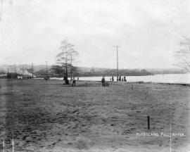
Part of Major Matthews collection
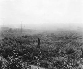
Photograph shows the area surrounding Kitsilano Beach after clearing.
Part of Major Matthews collection
Photograph shows the area surrounding Kitsilano Beach after clearing.
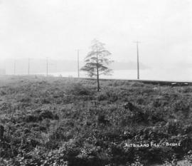
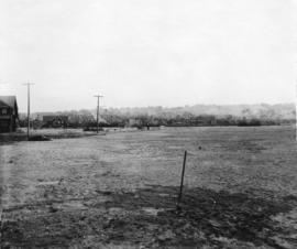
Part of Major Matthews collection
Photograph shows the area surrounding Kitsilano Beach before clearing.
Part of Major Matthews collection
Photograph shows the area surrounding Kitsilano Beach before clearing.
![[Kitsilano Indian Reserve, east of the Burrard Street Bridge]](/uploads/r/null/c/4/c44748477aa6ee98ce23e590bd306dc0b428eab790942a02495dbaa37e112845/fdb2aa2e-4efc-41c2-9a15-90b3993c2b9d-A09357_142.jpg)
[Kitsilano Indian Reserve, east of the Burrard Street Bridge]
Part of Major Matthews collection
Photograph shows Burrard Street Bridge, Granville Island, B.C. Electric Railway bridge across False Creek and area of reserve land, formerly an Indian garden.
![[People on Kitsilano Indian Reserve beach at foot of Chestnut Street]](/uploads/r/null/0/c/0cae8926d5605ab2e8eb98eb30accdddf895dc1d27ebb335795877b71a09cecf/1e98cc72-36c7-413d-9d72-d2e14cddc760-A09349_142.jpg)
[People on Kitsilano Indian Reserve beach at foot of Chestnut Street]
Part of Major Matthews collection
J.S. Matthews' notes with print or negative in Archives.
![[People on Kitsilano Indian Reserve beach by Burrard Street Bridge]](/uploads/r/null/c/4/c4467e9e451c58a5ef323a5f2c44ac645b658bb022ab9ed14b1414775acc6cc8/43715b1e-a5af-4c21-9023-2f09ce98fcb3-A09353_142.jpg)
[People on Kitsilano Indian Reserve beach by Burrard Street Bridge]
Part of Major Matthews collection
![[People on Kitsilano Indian Reserve beach by Burrard Street Bridge]](/uploads/r/null/e/8/e8a57f8c7bfdb281d09529f8c15ef51fb2871ed845dae57b13bbab005239b9da/da331da4-ac2d-4cec-9a19-46fef429835e-A09354_142.jpg)
[People on Kitsilano Indian Reserve beach by Burrard Street Bridge]
Part of Major Matthews collection
![[People on Kitsilano Indian Reserve beach near Cedar Street]](/uploads/r/null/5/e/5eb2c7d695531ec13a8ef96d3ff63ac3c8fe0e008ac254191b9832bc7b7c4fcf/6acd542f-9ef1-4da0-b2ef-552a7c0fde54-A09351_142.jpg)
[People on Kitsilano Indian Reserve beach near Cedar Street]
Part of Major Matthews collection
J.S. Matthews' notes with print or negative in Archives.
![[People on Kitsilano Indian Reserve beach near Pine Street]](/uploads/r/null/4/a/4a8077e43e9aeb06486bacab47b8aab0c72fa5036935d1c2b8dc0b3e3979cf89/5ed5019c-c339-4e7c-8636-5e5519a592b1-A09352_142.jpg)
[People on Kitsilano Indian Reserve beach near Pine Street]
Part of Major Matthews collection
J.S. Matthews' notes with print or negative in Archives.
![[People on Kitsilano Indian Reserve beach, east of Chestnut Street]](/uploads/r/null/d/3/d381459a158ec366f7de1eadb71aff5da63483ccffdf09d953621ca00bc0c737/1c84e499-59f3-4df7-b874-0fd7183df41a-A09350_142.jpg)
[People on Kitsilano Indian Reserve beach, east of Chestnut Street]
Part of Major Matthews collection
J.S. Matthews' notes with print or negative in Archives.
![[Shacks on shore of Kitsilano Indian Reserve]](/uploads/r/null/b/0/b01db3724b619dbd3003a0951790d34deeb68459f7b14a1bc000c1246e312b77/00bfca51-721d-45aa-b304-aaf26dd21521-A09356_142.jpg)
[Shacks on shore of Kitsilano Indian Reserve]
Part of Major Matthews collection
J.S. Matthews' notes with print or negative in Archives.
![[Site of Seaforth Armoury on Kitsilano Indian Reserve]](/uploads/r/null/5/3/5379cdb330c643b443916ea2354d52ada6ce1234f4480dddd066837bcc69868b/8382c8f3-f5f4-4fab-a277-ba05af41db42-A09359_142.jpg)
[Site of Seaforth Armoury on Kitsilano Indian Reserve]
Part of Major Matthews collection
Photograph shows location of armoury and houses, schools and buildings along Cornwall Street and Cypress Street. J.S. Matthews' notes with print or negative in Archives.
![[Site of Seaforth Armoury on Kitsilano Indian Reserve]](/uploads/r/null/9/d/9d85bd2d98b273b6518780e87fb4191e92eafd4e69b46ece216d0246f8666c55/621ad8e5-10b4-4a4d-a8cc-2a6e9e15f1e5-A09360_142.jpg)
[Site of Seaforth Armoury on Kitsilano Indian Reserve]
Part of Major Matthews collection
Photograph shows location of armoury and houses, schools, and buildings along Cornwall and Cypress Streets.
![[View of Kitsilano looking north from 1875 7th Avenue]](/uploads/r/null/6/2/62c2ffff1877a1ce6d7dfca2cd34e9fa80fd61822dce34ea3055b027236ed3c6/e4409ffc-079b-4d86-ba5b-48a4f110f201-A23640_142.jpg)
[View of Kitsilano looking north from 1875 7th Avenue]
Part of Major Matthews collection
Photograph shows Chief Samuel North's house at 1850 6th Avenue.
![[View of Kitsilano looking north west from West 7th Avenue and Cypress Street]](/uploads/r/null/c/8/c8888720eacb206279ba4f96527468422a73671f6238fd518d17fc2d3712d614/31639e37-b666-4358-9db7-5dc47d2b5e19-A23639_142.jpg)
[View of Kitsilano looking north west from West 7th Avenue and Cypress Street]
Part of Major Matthews collection

Part of Major Matthews collection
Photograph shows cars parked along Cornwall Street, people gathered for Olympic swimming trials at Kitsilano Pool, crowds at Kitsilano Pool, and houses and other buildings to the northeast. J.S. Matthews' notes with print or negative in Archives.
![[View of Vancouver looking northwest from 12th Avenue and Trafalgar Street]](/uploads/r/null/4/3/4329d5475601df7a38fd7cf25ece3bbd36deebf02adacd5ac18c490efd02a924/e61fd55a-800d-458f-8767-49fcd32a14ad-A09801_142.jpg)
[View of Vancouver looking northwest from 12th Avenue and Trafalgar Street]
Part of Major Matthews collection
Photograph shows vacant lot on corner, houses in Kitsilano and a view of the North Shore and mountains in the distance.