![[Houses in Kensington-Cedar Cottage]](/uploads/r/null/e/2/e2941d825f35b43e5c5e2732af55599459b71332fb28f129eafb1ee7721575eb/65f69524-8151-4d89-9e2a-2a898b088aa1-A58910_142.jpg)
[Houses in Kensington-Cedar Cottage]
- COV-S511---: CVA 780-130
- Item
- [between 1960-1980]
Part of City of Vancouver fonds
Photograph also shows the Lions and Trout Lake and John Hendry Park.
25 results with digital objects Show results with digital objects
[Houses in Kensington-Cedar Cottage]
Part of City of Vancouver fonds
Photograph also shows the Lions and Trout Lake and John Hendry Park.
![[Smoke rising from fire in Coal Harbour]](/uploads/r/null/d/d/c/ddc35c9a19e791e662e2dd1a0b8a997e2967980081d4d0affade216f322f70ef/0781f4a8-51f1-4559-ac66-2973729ac922-CVA354-359_142.jpg)
[Smoke rising from fire in Coal Harbour]
Part of City of Vancouver fonds

Downtown cityscape over Fairview and False Creek
Part of City of Vancouver fonds
Item part is a photograph of downtown Vancouver over Fairview and False Creek. The Granville Street Bridge and the Burrard Street Bridge are visible at the far left.

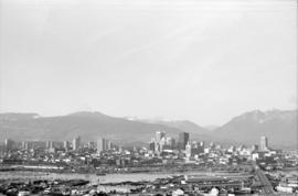
Downtown cityscape over Mount Pleasant, Fairview, and False Creek
Part of City of Vancouver fonds
Item part is a photograph of downtown Vancouver, including a view down Cambie Street across the Cambie Street Bridge, and adjacent neighborhoods in Fairview and Mount Pleasant.

Downtown cityscape over Mount Pleasant, Fairview, and False Creek
Part of City of Vancouver fonds
Item part is a photograph of downtown Vancouver, including a view down Cambie Street across the Cambie Street Bridge, and adjacent neighborhoods in Fairview and Mount Pleasant.
Downtown cityscape over Mount Pleasant, Fairview, and False Creek
Part of City of Vancouver fonds
Item part is a photograph of downtown Vancouver, including a view down Cambie Street across the Cambie Street Bridge, and adjacent neighborhoods in Fairview and Mount Pleasant.

Downtown cityscape over Mount Pleasant, Fairview, and False Creek
Part of City of Vancouver fonds
Item part is a photograph of downtown Vancouver, including a view down Cambie Street across the Cambie Street Bridge, and adjacent neighborhoods in Fairview and Mount Pleasant.

Downtown cityscape over Mount Pleasant, Fairview, and False Creek
Part of City of Vancouver fonds
Item part is a photograph of downtown Vancouver, including a view down Cambie Street across the Cambie Street Bridge, and adjacent neighborhoods in Fairview and Mount Pleasant.

Downtown cityscape over Mount Pleasant, Fairview, and False Creek
Part of City of Vancouver fonds
Item part is a photograph of downtown Vancouver, including a view down Cambie Street across the Cambie Street Bridge, and adjacent neighborhoods in Fairview and Mount Pleasant. The Granville Street Bridge and the Burrard Street Bridge are visible at the far left.

Downtown cityscape over Fairview, and False Creek
Part of City of Vancouver fonds
Downtown cityscape over Mount Pleasant, Fairview, and False Creek
Part of City of Vancouver fonds
Item part is a photograph of downtown Vancouver, including a view down Cambie Street across the Cambie Street Bridge, and adjacent neighborhoods in Fairview and Mount Pleasant.

Downtown cityscape over Mount Pleasant, Fairview, and False Creek
Part of City of Vancouver fonds
Item part is a photograph of downtown Vancouver, including a view down Cambie Street across the Cambie Street Bridge, and adjacent neighborhoods in Fairview and Mount Pleasant.

Downtown cityscape over Fairview, and False Creek
Part of City of Vancouver fonds

Downtown cityscape over Mount Pleasant, Fairview, and False Creek
Part of City of Vancouver fonds
Item part is a photograph of downtown Vancouver, including a view down Cambie Street across the Cambie Street Bridge, and adjacent neighborhoods in Fairview and Mount Pleasant.

Downtown cityscape over Mount Pleasant, Fairview, and False Creek
Part of City of Vancouver fonds
Item part is a photograph of downtown Vancouver, including a view down Cambie Street across the Cambie Street Bridge, and adjacent neighborhoods in Fairview and Mount Pleasant.

Downtown cityscape over Mount Pleasant and False Creek
Part of City of Vancouver fonds

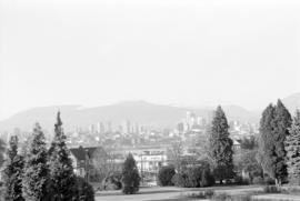
Downtown view over Fairview neighborhood
Part of City of Vancouver fonds
Item part is a photograph of the top of the downtown Vancouver skyline over the trees of a Fairview neighborhood. This photograph was taken from one of the lower floors of the Plaza 500 Hotel & Convention Centre.

Downtown view over Fairview neighborhood
Part of City of Vancouver fonds
Item part is a photograph of the top of the downtown Vancouver skyline over the trees of a Fairview neighborhood. This photograph was taken from one of the lower floors of the Plaza 500 Hotel & Convention Centre.
Downtown view over Fairview neighborhood
Part of City of Vancouver fonds
Item part is a photograph of the top of the downtown Vancouver skyline over the trees of a Fairview neighborhood. This photograph was taken from one of the lower floors of the Plaza 500 Hotel & Convention Centre.
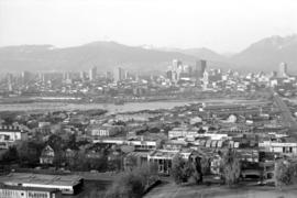
Vancouver Cityscapes - Downtown, Fairview, Mount Pleasant
Part of City of Vancouver fonds
Item is a set of negatives of cityscape photographs taken mostly from the upper floors of the Plaza 500 Hotel & Convention Centre at 500 W. West 12th Avenue, at the intersection of West 12th Avenue and Cambie Street, looking north. The subject material of the photographs is predominantly downtown Vancouver, the North Shore Mountains, False Creek, and the Fairview and Mount Pleasant neighbourhoods. This set contains the raw photographs from the roll the photographer shot in their original order. The associated contact sheet has selection marks for frames 16, 21, 23, and 25.
![[Northwest facing cityscape view of Mount Pleasant, False Creek and Downtown]](/uploads/r/null/a/8/a87cf5cf19ae87f08c8a84b680215623baab879c47c16682d33de88e63056e1a/0fe4358c-f755-4cb7-ae82-212af70d5d7b-A59086_142.jpg)
[Northwest facing cityscape view of Mount Pleasant, False Creek and Downtown]
Part of City of Vancouver fonds
Photograph also shows sawmills along False Creek, the North Shore, and the Lions; photograph also shows buildings downtown including the Hotel Vancouver (900 West Georgia Street)
![[Northwest facing cityscape view of Mount Pleasant and Downtown]](/uploads/r/null/d/a/da130ea231fd00e2f264f71a2d8411bb91248bd27e938e1f525d72d87c62a7fd/3dc3cbeb-51c8-416f-af5c-838becd2699d-A59085_142.jpg)
[Northwest facing cityscape view of Mount Pleasant and Downtown]
Part of City of Vancouver fonds
Photograph also shows False Creek, sawmills along False Creek, the North Shore and the Lions; photograph also shows buildings downtown including the Marine Building (355 Burrard Street), Georgia Medical Dental Building, and the Hotel Vancouver (900 West Georgia Street)
![[Northwest facing cityscape view of Mount Pleasant]](/uploads/r/null/1/a/1a8e45a404893b76fbce13ae65f1d98bf633b22ee02126f11bda277730967c14/ff1fc560-a87d-486b-8fc6-c2ddbed44d41-A59084_142.jpg)
[Northwest facing cityscape view of Mount Pleasant]
Part of City of Vancouver fonds
Photograph also shows False Creek, sawmills along False Creek, Burrard Inlet and the North Shore; photograph also shows buildings downtown including the Marine Building (355 Burrard Street), Dominion Building (207 West Hastings Street), and the Sun Tower (100 West Pender Street)
![[Cityscape view of downtown looking North-West]](/uploads/r/null/b/9/b95782e50593bd4e9637c37355cf72f23fab74f503462817d0f2cf4472f787c8/326767f9-9f75-4af1-aef4-d2c325cfdd3e-A58786_142.jpg)
[Cityscape view of downtown looking North-West]
Part of City of Vancouver fonds
Photograph also shows the Lions and housing on the North Shore