![Bayview [Elementary] School [at 2251 Collingwood Street]](/uploads/r/null/8/4/84146e68cd846eeeaae7e2bd5b42caedb758a2b24321969f1526b2cf31663f39/ec8a093d-2991-41d4-ae38-c216a26dc428-A58959_142.jpg)
Bayview [Elementary] School [at 2251 Collingwood Street]
![[Kitsilano] Ice Rink [at 2495 West 12th Avenue]](/uploads/r/null/e/b/eb721478621e4bda9a57c84a63bed97f2584c3d59a11c99b4a350144e51252bd/dc26c67f-7ca8-4fe5-807c-7e3c8c3c65dc-A58967_142.jpg)
[Kitsilano] Ice Rink [at 2495 West 12th Avenue]
![Simon Fraser [Elementary] School [at] 3185 Manitoba [Street]](/uploads/r/null/c/e/ceb7f0a743608fb0d43a03fedf7e0accac463f28944ff1fd2e6fb5ec70f58488/ec148232-5579-42c1-ac42-8a85607ed3de-A59091_142.jpg)
Simon Fraser [Elementary] School [at] 3185 Manitoba [Street]
![Shaughn[essy Elementary] School [at 4250 Marguerite Street]](/uploads/r/null/6/a/6af8bd8506d9332ec561ec9a2b132e98867e98b7d4c797370c6c707534cb8634/f3bdba72-facf-45ab-b3ab-e5a38a7d486e-A59154_142.jpg)
Shaughn[essy Elementary] School [at 4250 Marguerite Street]
![[The Vancouver] Chinese Public School [at] 499 E[ast] Pender [Street]](/uploads/r/null/9/a/9a4d898a4390e8a2cc895d51a65b2329c57ef923bce8139f2a23201e1392e2ce/dbe7f86b-7921-47b8-954b-5132f9ab67f3-A59159_142.jpg)
[The Vancouver] Chinese Public School [at] 499 E[ast] Pender [Street]

Sequoia sempervirens, Point Grey School
![[School buidling]](/uploads/r/null/4/1/d/41d180811de4ef150e9fc20cbf7713ab4a27b51a03f02ed12164b22e4ad4b47f/8bca8e93-bc97-42e0-a7ad-fa3bccedcee8-CVA1095-08699_142.jpg)
[School buidling]
![Bayview School [group photograph]](/uploads/r/null/5/7/571b8afe7da55c7f099d52696be6bfb868e54ff58d193d8a0719fb50a21716f6/0ad008aa-ed5b-4423-8ab9-90abc2d35481-A59802_142.jpg)
Bayview School [group photograph]
![Bayview School [group photograph]](/uploads/r/null/b/9/b93ccc48c18d2949827ffb5c018527c33d15fc46a5fff67a4e5ced3f3930f1d8/1f53fe4a-2757-40ef-8e19-ab86702400d3-A59803_142.jpg)
Bayview School [group photograph]
![City of Vancouver [park sites June/80]](/uploads/r/null/9/4/9484add7c4684ea3838e4d00ee8add3ecf85d78d5aa8fe2780cae273e59556a5/bd2464d8-2aa9-4501-aba6-8b3f7d130a42-MAP1032_142.jpg)
City of Vancouver [park sites June/80]

City of Vancouver, British Columbia

Sheet 9 : Clark Drive to Slocan Street and Triumph Street to Charles Street

Sheet 11 : Carrall Street to Clark Drive and waterfront to Keefer Street

Sheet 15 : Oak Street to Main Street and False Creek to Sixteenth Avenue

Sheet 21 : Burrard Street to False Creek and waterfront to Robson Street

Sheet E : University Endowment Lands to Wallace Street and Sixteenth Avenue to Twenty-seventh Avenue

Sheet K : Wallace Street to Trafalgar Street and Twenty-seventh Avenue to Thirty-eighth Avenue

Sheet Q : Churchill Street to Cambie Street and Thirty-eighth Street to Forty-ninth Avenue

Sheet 6 : Craddock Street to Boundary Road and Twenty-ninth Avenue to Fortieth Avenue

Sheet 16 : Maple Street to Oak Street and False Creek to Sixteenth Avenue

Sheet 7 : Clark Drive to Slocan Street and Seventh Avenue to Eighteenth Avenue

Sheet S.V. 14 : Duchess Street to Boundary Road and Twenty-ninth Avenue to Fortieth Avenue

Sheet 13 : Ontario Street to Clark Drive and First Avenue to Sixteenth Avenue

Sheet 15 : Oak Street to Main Street and False Creek to Sixteenth Avenue

Sheet 17 : Trutch Street to Maple Street and Fourth Avenue to Sixteenth Avenue

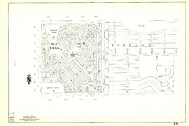
Sheet 23 : Stanley Park to Granville Street and Robson Street to False Creek

Sheet C : University Endowment Lands to Discovery Street and Fourth Avenue to Sixteenth Avenue

Sheet D : Discovery Street to Trutch Street and Fourth Avenue to Sixteenth Avenue

Sheet G : Trafalgar Street to Granville Street and Sixteenth Avenue to Nanton Avenue

Sheet N : Musqueam Reserve to Wallace Street and Thirty-eighth Avenue to Forty-ninth Avenue

Sheet O : Holland Street to Elm Street and Thirty-eighth Avenue to Forty-ninth Avenue

Sheet Q : Churchill Street to Cambie Street and Thirty-eighth Street to Forty-ninth Avenue

Sheet W : Fraser River to French Street and Fifty-ninth Avenue to Seventy-first Avenue

Sheet S.V. 6 : Prince Edward Street to Bruce Street and King Edward to Thirty-fifth Avenue

Sheet S.V. 7 : Prince Edward Street to Argyle Street and Thirty-fifth Avenue to Forty-seventh Avenue

Sheet S.V. 8 : Prince Edward Street to Argyle Street and Forty-seventh to Fifty-eighth Avenue

Sheet S.V. 11 : Fleming Street to Killarney Street and Thirty-seventh Avenue to Forty-eighth Avenue

Sheet S.V. 12 : Fleming Street to Raleigh Street and Forty-eighth Avenue to Newport Avenue

Sheet 6 : Nicola Street to Beatty Street and English Bay Beach to Georgia Street

Sheet 63 : Carnarvon Street to Cypress Street and Forty-first Avenue to Thirty-third Avenue
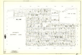
Sheet 27 : University Endowment Lands and Drummond Drive to Camosun Street and Fourteenth Avenue to Fourth Avenue

Sheet 30 : Maple Street to Oak Street and Fourteenth Avenue to Third Avenue and False Creek
Sheet 36 : Rupert Street to Carlton Avenue and Twenty-second Avenue to Grandview Highway

Sheet 43 : East Boulevard to Oak Street and Laurier Avenue to Fourteenth Avenue
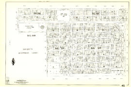
Sheet 45 : Discovery Street to Blenheim Street and King Edward Avenue to Fourteenth Avenue

Sheet 52 : Inverness Street to Nanaimo Street and Thirty-second Avenue to Twenty-second Avenue

Sheet 66 : Musqueam Indian Reserve to Balaclava Street and Forty-ninth Avenue to Forty-first Avenue

Sheet 74 : Inverness Street to Nanaimo Street and Sixty-first Avenue to Forty-ninth Avenue

Sheet 75 : Nanaimo Street to Kerr Street and Bobolink Avenue to Forty-ninth Avenue

Sheet 81 : Main Street to Inverness Street and Southeast Marine Drive to Fifty-seventh Avenue