Showing 109 results
Archival description![[R.C.A.F. Maritime Air Command plane No. 102 flying over English Bay]](/uploads/r/null/1/3/13b6c7a118ed10801cfbe633df28806771f06f62a484edbf5de83c5acd20e0a4/ff8af309-b1af-4c30-9216-ba8a2859660d-A71302_142.jpg)
[R.C.A.F. Maritime Air Command plane No. 102 flying over English Bay]

Looking across English Bay from the beach on Point Grey Road
Vancouver, B.C.
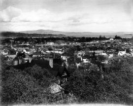
![[View from the Fairview-Mount Pleasant area looking north]](/uploads/r/null/3/8/38e35eed76b25b54ee936c701665ac1b51730799bb74c0c6b4d3f6e35dfa4e02/ab6491d0-1922-485b-b624-dfb289594a9c-A65314_142.jpg)
[View from the Fairview-Mount Pleasant area looking north]
![[Military camp near Vernon]](/uploads/r/null/f/2/0/f209c6aac94b5a37b8e033ec4f3d9c45ffbfe3fabf794ddf5ac3a16ac1ae6540/0f360e46-6651-4b67-890b-e66087441b7b-CVA73-3_142.jpg)
[Military camp near Vernon]
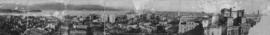
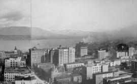
Panorama of Vancouver, B.C. Canada
![[View looking across the water towards Siwash Rock]](/uploads/r/null/6/1/613c1385f3a5e8688fea1d22cf59ae8e37337c93055e8d651a41647934230d24/8edbf55b-e737-45c9-b299-47db9e32407f-CVA1376-737_142.jpg)
[View looking across the water towards Siwash Rock]
![[View looking south showing the Dominion Building and the dome of the old Court House]](/uploads/r/null/c/b/cb6c4813e59a3d8087b16305354747eb9b89aeed489864528dded61eed6b337b/48734afb-985d-446c-b8a0-da53d0dd4e08-CVA1376-736_142.jpg)
[View looking south showing the Dominion Building and the dome of the old Court House]
![[Aerial view of Vancouver]](/uploads/r/null/9/b/9b3acec26123edc53f11bf2f41f3286d09254ffea9918cd31b6715395ebe18d0/26473909-fe49-4474-8c3f-05eb1e8ab059-CVA1376-252_142.jpg)
[Aerial view of Vancouver]
![Looking north, our house [in Cedar Cottage]](/uploads/r/null/d/c/dcd996eac0a13402f4d8523881fb8c843a7e540f74defd5934cbc0f7e8aef362/03eb79a9-190d-4494-96af-15b33b1b7a0a-A43610_142.jpg)
Looking north, our house [in Cedar Cottage]
![Flett Road [East 18th Avenue] east of Knight Road [Street in Cedar Cottage]](/uploads/r/null/5/d/5d59076afb046ed723b664f2d976a42d6191b20f58a870480a1b3a104f9b3e62/3962b6fd-a308-416a-9d1d-3dd2d4494166-A43626_142.jpg)
Flett Road [East 18th Avenue] east of Knight Road [Street in Cedar Cottage]
![Looking south from Knight Road [Street and 15th Avenue in Cedar Cottage]](/uploads/r/null/c/4/c40d25f0ce8d064000ee17882a33987e35d7dd3b1a95c189c9745f99adecc4b6/cca6bd4c-d41c-4105-a346-3e034016f971-A43609_142.jpg)
Looking south from Knight Road [Street and 15th Avenue in Cedar Cottage]

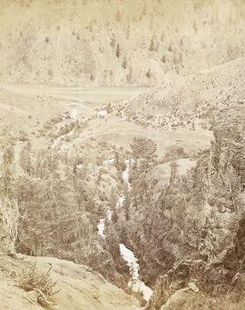
Upper Capilano Canyon
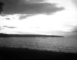
Sunset from English Bay looking towards Point Grey
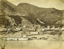
Golden B.C.

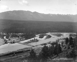
Bow Valley from C.P.R. Hotel
![C.P.R. Hotel from across the Bow [River]](/uploads/r/null/6/7/67123ef2c87b6798e0cfaac1f764f7e119c3b51efc66b476abcb2eee7f4e4e28/415b9b34-4136-4267-aef8-7b547e494120-A20028_142.jpg)
C.P.R. Hotel from across the Bow [River]

A bit of Granville Street
![C.P.R. Hotel from across the Bow [River]](/uploads/r/null/d/3/d3a80de5b951f1842415374308c3a996d505e2e41da6e75237d796f48373a3c0/db67449f-16bd-482f-8c40-73bfb8fb65fa-A20027_142.jpg)
C.P.R. Hotel from across the Bow [River]
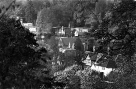
View of the village of Petersham, Surrey, England

View looking north over downtown Vancouver, across Burrard Inlet to North Shore
View looking north east over downtown Vancouver towards Burrard Inlet

View from Vancouver Hotel looking north over the city to Coal Harbour towards Deadman's Island and Stanley Park
![[View of sailboats on Burrard Inlet and Vancouver from Stanley Park]](/uploads/r/null/f/b/fbaf70f8f3d8ffefca70cd2c53cbbe2f87d29bd8fe398a1ee4aa71af1aec787b/fe804e4a-41df-4749-a5a9-c95b3e9a1e5e-A36236_142.jpg)
[View of sailboats on Burrard Inlet and Vancouver from Stanley Park]

Tunnel No. 2 and Yale looking down valley from far side of river
![Yale [showing] gold field opposite [across Fraser River]](/uploads/r/null/c/3/c3b5a65995f782ba54ae03df2bc55bc472f06f2cd8d25cf526390df9e47e33c8/de7cdbe7-5ba9-447a-a911-7c4a52876faf-A19666_142.jpg)
Yale [showing] gold field opposite [across Fraser River]
Yale from the gold field

Yale looking up the river
![Lady Franklin Rock [in the Fraser River near Yale]](/uploads/r/null/3/0/30e4a67b983698de8acc03740dd17a80e4f7a567b29da2ea51be9ea5c379c930/ee5161f4-0613-4294-9296-359f4eb8958f-A19670_142.jpg)
Lady Franklin Rock [in the Fraser River near Yale]

Nicaragua Bluff and wagon road from west side of Fraser River
Nicomen looking down the creek to the Thompson River - 67 miles above Yale

Alexandra Bluff and suspension bridge 13 miles above Yale from the far side of the river looking down valley (cutting 131 feet deep) here Mr. Ebert's was killed Jan. 15th, 1881

Illecillewaet Valley from Look Out on Mount Abbott
![[View of Kitsilano pool] from 2330 Cornwall [Avenue]](/uploads/r/null/7/6/76608ed98f533d56b1153af09c365dc9a5c7a4258ec97635422d804b2b6f2424/e9da7371-14fc-4f2c-98f0-ceb095ca6070-A71782_142.jpg)
[View of Kitsilano pool] from 2330 Cornwall [Avenue]
![[View of Vancouver from Stanley Park]](/uploads/r/null/5/2/52315ca8f9a2fbedb2dbf9d94b4312e028d91a8469b11105d8b164dcccf85bfc/9373455d-83c7-48d1-a95c-8a0054668699-A71774_142.jpg)
[View of Vancouver from Stanley Park]

Summer sun melts the 35 feet of snow and shows the last of our Western Ice Shield resting on a bed of cinders
A City Built of Wood
![[View from the Lions Gate (First Narrows) Bridge]](/uploads/r/null/c/b/cbfaf365b669500be57ca711731ac45b780e5cbdbc42a9e9b96bd2c5e7eb1725/e0e6f596-20e0-42db-858b-600990a57ef5-A71422_142.jpg)
[View from the Lions Gate (First Narrows) Bridge]

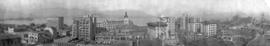
[View of the West End looking north from the roof of the nurses' residence of St. Paul's Hospital at 1056 Comox Street]
![[View of downtown Vancouver from the Fairview-Mount Pleasant area looking north]](/uploads/r/null/d/a/da0e60f039af32fb4e690e6f4fb4c0eb54e56e1da4db20349966b17c0d994822/d9027b1b-b0e1-4d17-acda-c126e0b6f82b-A37814_142.jpg)
[View of downtown Vancouver from the Fairview-Mount Pleasant area looking north]

The Promenade. English Bay
![[View of a distant steamboat]](/uploads/r/null/4/0/40ed66f6f7fe67ddb40836f5a85db6555331e98f8387f4651b1e2527ec0ae014/ed0fff23-ccb5-477a-897b-1d8341d26c04-A71851_142.jpg)
[View of a distant steamboat]
![[View of sailboats on English Bay]](/uploads/r/null/e/3/e3b8da1a59bb943522a93c5dc7e92142f74b5f05bf79f281aa5a543c7c7f978a/71c8c866-d1d8-4b09-9b04-ca15f9464dca-A71848_142.jpg)
[View of sailboats on English Bay]
![[People sitting on benches enjoying the view]](/uploads/r/null/f/2/f2297a6ddaf371b8434aa486cb82614fdd15854c1c4abf09f4a48a8d0b227e32/46e5f70e-2dfd-4622-8d9f-46411a65da05-A71861_142.jpg)
[People sitting on benches enjoying the view]
![[View of Burrard Inlet through the trees]](/uploads/r/null/5/9/590fb56f965b894116f0d1dbb79d0122a0813f47e295e765f49292f1614f30ae/3d5aa8b3-f909-4f46-a7de-4414b7f95ad6-A71827_142.jpg)
[View of Burrard Inlet through the trees]
![[View of English Bay through the trees]](/uploads/r/null/d/2/d25da78719a2f9e571c17517ae27aab92f93704236d13051f62a33ec7763f8d6/cde74a64-71dd-490c-b1e4-0f70608a3856-A71830_142.jpg)
[View of English Bay through the trees]
![[View of sunset over English Bay]](/uploads/r/null/7/a/7a49baa8205a2bb2570359553b782a300d7937bc8e532a64394695aaf0bfe2d0/78976384-d308-4711-82f5-b257b198919a-A71852_142.jpg)
[View of sunset over English Bay]
![[View towards Point Grey]](/uploads/r/null/6/4/64d0516f86d40e8ebd5d19468837059cd6ee410295d69470fe1c3774fa8eb260/3b4aa37b-8468-4dd2-95f0-725226457dc8-A71868_142.jpg)
[View towards Point Grey]
![[View towards Siwash Rock]](/uploads/r/null/7/7/779620b766a84ada8014c41142eeef05a7912fe697fb02e741c241f21c523ba1/61dcb26c-d9ae-4d0d-b7fb-c183c593d077-A71841_142.jpg)
[View towards Siwash Rock]

Along the Narrows
Results 1 to 50 of 109