![[View of] new houses on Rushmore Heights](/uploads/r/null/5/a/5a664a8112e768daa14d249c89466efed189e4bdef0daf6802c2088e0e95c3f5/e9f0f8e2-1b5a-4035-a848-c36fb9cb51fe-A03487_142.jpg)
[View of] new houses on Rushmore Heights
- AM1545-S3-: CVA 586-864
- Item
- [1942?]
46 results with digital objects Show results with digital objects
[View of] new houses on Rushmore Heights
![Scenic [view on] Vancouver Island](/uploads/r/null/e/3/e3c4157bbd7023413f30bc06e776b41cb804f7f09eeb4a030dca40025d57e7c7/5a6b44f0-2c1a-44a8-ad3c-cd6d59b4418d-A07418_142.jpg)
Scenic [view on] Vancouver Island
Photograph shows a farm among the trees. Inscription on verso of print "Near Mission, B.C."
Steffens-Colmer notebook identifies photograph as "Scenic log fences and trees, Van. Is."
![Scenic [view of the] Inside Passage](/uploads/r/null/4/5/451523251b96782e610d4c76f0ac95d9b2639be5085660e50fa6aa5b31d3876e/2e06d2ea-b955-46d0-ac9d-bfd98d501197-A07304_142.jpg)
Scenic [view of the] Inside Passage
![[The Burrard Bridge]](/uploads/r/null/0/5/05c95422d5df43694741f18972703078de60102bae42214ec23e03e7431a1720/6c4dce6f-5aca-4843-8e9d-c937c59d706a-A03429_142.jpg)
![[View of False Creek looking east from the Burrard Bridge]](/uploads/r/null/8/4/84922323cf591c851fbd4ab5489c940a600fdeb6911c11e122f77b8c798c04a2/5a3406ee-9419-4ebd-bd85-d51cecb6e953-A03428_142.jpg)
[View of False Creek looking east from the Burrard Bridge]
Photograph shows the Kitsilano Trestle and Granville Bridges
![[View looking east from North Hill]](/uploads/r/null/8/5/8511db470a751932697ac0bd128f45f9ce8f891b2fe38b51bf4a46639f05bcaf/c413d773-a3be-4e19-9775-7ed2b146c602-A07246_142.jpg)
[View looking east from North Hill]
Inscription on verso of print "#2522 - East Calgary from the 'North End', Calgary, Alta / Don Coltman Photo"
![[Looking west across the Bow River from North Hill]](/uploads/r/null/b/6/b6dbadac3b3a5f7c01e4338b90434397e40c9261b3cecfe75d42c843e7f56a5c/ac0a92de-e4a4-40d7-8a11-8283616b3d4c-A07245_142.jpg)
[Looking west across the Bow River from North Hill]
Inscription on verso of print "#2521 Looking West .. Bow River .. from North Hill Calgary Alta."
![[View across the North Saskatchewan River looking west]](/uploads/r/null/3/2/3270d431b47171258bc69ea34ae78399c1968495c13fb14919d685ca616d7b0b/dca7edc8-44fa-4845-a568-65c1b3368234-A07244_142.jpg)
[View across the North Saskatchewan River looking west]
![[View across the North Saskatchewan River]](/uploads/r/null/4/4/44bb46f1ed1a0f7b2c8c56ef9bc84c3872cca5a1518c0baa89f163a8f4dddd90/5a161060-321c-41e5-90db-9f4e522d1f79-A07241_142.jpg)
[View across the North Saskatchewan River]
Photograph shows university buildings in the background
![[View across the North Saskatchewan River]](/uploads/r/null/d/1/d1e0726a2ee0cc278c42e35106e5d2b6aafc8875bd97d9ee40c69edf0f4703e4/8423392c-41fa-4fa1-9d23-4f9c3b1b109b-A07240_142.jpg)
[View across the North Saskatchewan River]
Inscription on verso of print "#2515 - Saskatoon Sask. North Saskatchewan River, / University Buildings, upper right. / Don Coltman Photo"

Burrard Street from the Marine Building
Photograph shows a view looking south from Hastings Street including the Hotel Vancouver
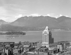
![View of Vancouver Harbour from [the] Marine Building](/uploads/r/null/a/e/ae71b8edf582f04cd127108b112156f9d1e81af53f3de808e7359e541ab4333e/502882b8-ed7f-4493-9a93-b2a0bd5e6b15-A06614_142.jpg)
View of Vancouver Harbour from [the] Marine Building
Photograph shows Pier B-C

Burrard Inlet from Stanley Park
![[View of] Banff from [the] Alpine Clubs](/uploads/r/null/6/1/6165869500910601873a36c011125b99808b831a0103205d28793d305a01b76f/08c0c399-8201-4219-9160-c6161dcf4e6a-A07135_142.jpg)
[View of] Banff from [the] Alpine Clubs

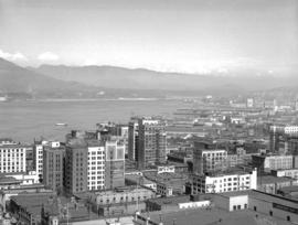
Vancouver from top of old Hotel Vancouver
Photograph shows a view looking northeast

Vancouver from top of old Hotel Vancouver
Photograph shows a view looking north showing Pier B-C, the Main Post Office, the Royal Bank Building and ferries
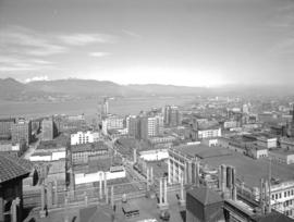
Vancouver from top of old Hotel Vancouver
Photograph shows a view looking northeast including the eastern docks
Vancouver from top of old Hotel Vancouver
Photograph shows a view looking northeast and a man sitting and a baby carriage on the roof of the hotel

City of Vancouver from top of City Hall
Photograph shows a view looking northwest including part of Fairview, False Creek, the Cambie Bridge, the Kitsilano Trestle and Burrard Bridges and Downtown in the background

City of Vancouver from top of City Hall
Photograph shows a view looking northwest including part of Fairview, False Creek, the Kitsilano Trestle and Burrard Bridges

City of Vancouver from top of City Hall
Photograph shows a view looking north including part of Fairview, the Cambie Bridge, False Creek and Yaletown, Downtown and the Lions in the background

Photograph shows the waterfront
Photograph shows the Immigration Building, the Marine Building and Deadman's Island

Photograph shows the lighthouse and Downtown in the background
![Turner Valley Oil [scenic view]](/uploads/r/null/f/e/fe09f263cc416550f71dc4af3fb5855810a6a2e52189855b73f3846f6f4538ab/6e812c09-daa8-44e5-b54a-91a483f78040-A07117_142.jpg)
Turner Valley Oil [scenic view]


Photograph shows the hostel under construction
![[View across the water from] Sandspit [on the] Queen Charlotte Islands](/uploads/r/null/2/7/278b146d67391964b22a9a530a7518a8093c13eccb46f019936e4b70351f2f1a/d0720a1b-fe6e-4c73-9de6-8df0b6289b10-A14947_142.jpg)
[View across the water from] Sandspit [on the] Queen Charlotte Islands
![[Looking across the water from] Pacific Mills [dock on the] Queen Charlotte Islands](/uploads/r/null/2/8/287b948daf5968d243170070627b05292ccfc0f574696c223db2a8274093544c/23b71184-a2ee-44d3-b4a3-34c561b1cd98-A14906_142.jpg)
[Looking across the water from] Pacific Mills [dock on the] Queen Charlotte Islands
Photograph shows the "Alco III" from Vancouver
![[View from a] Pacific Mills [logging site on the] Queen Charlotte Islands](/uploads/r/null/7/5/75ff02caa339fcdfd97719730256158de9acc744e1ce1760d16519fd3037e70c/0b929a8d-1f49-4cf4-94eb-c9b6a8bb0543-A14880_142.jpg)
[View from a] Pacific Mills [logging site on the] Queen Charlotte Islands
![[View overlooking] Pacific Mills [logging site on the] Queen Charlotte Islands](/uploads/r/null/9/e/9e659a899df427d86cce937d8d377beb1a308cb91a92ef9d086a9b1664c06c27/d6cd8f45-83e8-47d7-a7f4-8a32e0771130-A14879_142.jpg)
[View overlooking] Pacific Mills [logging site on the] Queen Charlotte Islands
![Garibaldi Mountain [showing] Columnar Mountain in foreground](/uploads/r/null/7/a/7a807283493af89ef88093dcfdd0d493e90a1ab7fa284188f7469742e55ed884/bc950e1c-7515-4968-97f9-6ce80cbabbbb-A14811_142.jpg)
Garibaldi Mountain [showing] Columnar Mountain in foreground
![First cabin of Garibaldi Hostels [under construction]](/uploads/r/null/3/6/36fbfd7c3c8b1e784cdfb4cdf3ad89b7ad41c911ee8a399682e0fc9b8a8f2a1c/8af065dd-a87a-4fbb-b0da-86f1f5798814-A14810_142.jpg)
First cabin of Garibaldi Hostels [under construction]
Photograph shows the Mamquam Range in the background

View of Upper Howe Sound (Squamish) from Empire Mills' upper camp on way to Garibaldi Hostels

![The Black Tusk [in] Garibaldi Park](/uploads/r/null/0/f/0f42a3ad1d828a1498d595ff36b7e3a6bfb035bda959e09e2f93ced0dfc7aa46/edcc0e8c-236f-485a-b500-a31e5c9d72ef-A14807_142.jpg)
The Black Tusk [in] Garibaldi Park
![[View of] townsite [at] Pacific Mills](/uploads/r/null/2/2/222dfa3de5235348fbe93262504c9166ea84d15c5790f8b58ab838306955b9b3/242300f5-3c03-45d0-89c4-104e9aff97bd-A14782_142.jpg)
[View of] townsite [at] Pacific Mills
![[View of] townsite [at] Pacific Mills](/uploads/r/null/6/8/68ed185eccdf9ab912cdfe592c5a1bbccf534ed0c0b2fd2cb2f6403b359eae3a/1d04146c-c3d0-4a5e-a781-d6df275e657c-A14781_142.jpg)
[View of] townsite [at] Pacific Mills
![[View of] townsite [at] Pacific Mills](/uploads/r/null/c/1/c1a22944348414406d5d0d44f48c2ba6a714665c651a822617a78113f9df8a67/228a6b5f-227a-4fd3-b128-71f0b8287581-A14780_142.jpg)
[View of] townsite [at] Pacific Mills
![Town and mill from booming grounds [at] Pacific Mills](/uploads/r/null/9/f/9faf5089eab394c796b6a8c6068bb24041ec4596502f1542a1c23c928050a01a/497b21f2-cebf-4a31-a7fc-0648b0f7eb51-A14753_142.jpg)
Town and mill from booming grounds [at] Pacific Mills
Photograph shows a Davis Raft
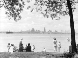
![Barge [and] Vancouver sky line](/uploads/r/null/8/f/8ff5d35b3ba17768ab38a2181b76e469ae277a943e748f46685af78cff5f884c/625c0fa9-676a-4da5-b3b7-d8b8b671cdfd-A05485_142.jpg)
Barge [and] Vancouver sky line

Photograph shows a view looking north including the Immigration Building, C.P.R. Pier A and the Marine Building and Burrard Inlet and the North Shore in the background
![[View of] bridge and Holy Cross Mt. near Hope, B.C.](/uploads/r/null/c/2/c285d8b9f5b8af7f7922097d09089993530fc2a717e7036ff70852a0aa7f3d6d/254672a2-4993-4d93-aadb-7ce07e20c70f-A06918_142.jpg)
[View of] bridge and Holy Cross Mt. near Hope, B.C.
![[View of] Brentwood and Inlet from Malahat, Vancouver Island](/uploads/r/null/6/6/66be6787377e14cbb31921ab1a269f2e710c4d93765fc37952afe4e8ab781b12/f1251454-6783-4e75-88d4-3d7a5793c76b-A03307_142.jpg)
[View of] Brentwood and Inlet from Malahat, Vancouver Island
![[View at the top] of Mt. Seymour]](/uploads/r/null/d/a/dae027646b8924703e2de2d84b7667d6ba492cd3dc47edc6c3fb3e133a4e9f75/d306ca4d-761b-4e99-b535-0c417d2216d3-A03302_142.jpg)
[View at the top] of Mt. Seymour]