![[Longshoremen loading ship]](/uploads/r/null/f/8/f8ca850f0760e7e72f0b91b80a7ddec43ba103a1d179e0563a12b8d3f63b4494/ae1bf200-2184-4ef4-954b-b8587293ddd2-A06321_142.jpg)
- AM1545-S3-: CVA 586-4007
- Item
- Sept. 1945
![[Longshoremen loading ship]](/uploads/r/null/5/4/54fd19aabf7a3b9baccfe3c05ee13c2c92cd7f3bed3562bfbbf934173d8895a3/427cea28-dddc-4680-9970-03d7d016c814-A06322_142.jpg)

![[Men using cranes to load boxes onto Canadian-Australasian Royal Mail Line ship "Niagara"]](/uploads/r/null/4/1/418bbd8f1fd621417da78f7e90c239abfb33e74830f062119c4f1a77b4ffd5ef/594d5dc2-631b-4618-a63d-bc9ec391268f-A08728_142.jpg)
[Men using cranes to load boxes onto Canadian-Australasian Royal Mail Line ship "Niagara"]
Part of Major Matthews collection
J.S. Matthews' notes with print or negative in Archives.
![[Loading of horses onto a steamship]](/uploads/r/null/a/0/a0cc92620c22732c80c94ec8244f537bfa93279c1ff3f381d7ba2254532dadf9/7b0074a2-c38d-419a-b61d-5b771837da7f-A23790_142.jpg)
[Loading of horses onto a steamship]
Part of Major Matthews collection
![[Men unloading ship at Stimson's wharf]](/uploads/r/null/4/3/437b84ee5abe17e64c595e183e14e444dbaa71da194688dd069249d4c5248727/ec1c3405-bccb-47a9-a912-5a282edbfabc-A23930_142.jpg)
[Men unloading ship at Stimson's wharf]
Part of Major Matthews collection
Third man on right identified as W.G. Calder
![[Cargo of tea on dock from the "W.B. Flint"] 1st Tea Ship](/uploads/r/null/f/a/fab5e9fee54b6d5944f028b0c8c9cb2d7445ac2aff28b6d3ffd308835406a30e/1baea273-e2ce-4aed-ab9b-f5c780e82bcd-A23957_142.jpg)
[Cargo of tea on dock from the "W.B. Flint"] 1st Tea Ship
Part of Major Matthews collection
Men identified left to right: F.F. Nelson, Mr. Forrest, H. Abbott, C.T. Conover, J.B. Tiffin
![[Group portrait of L.D. Taylor, Sir Henry Thornton, [Frank D.?] Russell, Port Superintendent K.[...](/uploads/r/null/b/4/b45f01667b7496836c5ca82064ad935e8d869c48ce7f3338e0fc98f8d63b3b9c/dac1d068-9a52-4ea5-b78a-ea8d34f7c3a6-A49150_142.jpg)
Part of L.D. Taylor family fonds
![[Opening ceremony for C.P.R. Piers B and C]](/uploads/r/null/5/3/536d5fcf2d75a8f75deba74d095f05e94abad0fa4d3d6992fb11b0725491a74e/e00b4318-5028-43a9-b2a5-fa71c1f11bfd-A51165_142.jpg)
[Opening ceremony for C.P.R. Piers B and C]
Part of L.D. Taylor family fonds
Photograph shows Mayor L.D. Taylor and C.P.R. President and Chairman E.W. Beatty holding a scroll tied with ribbon. C.A. Cotterell, General Superintendent for the B.C. District of the C.P.R., stands to the left.
![[Opening ceremony for C.P.R. Piers B and C]](/uploads/r/null/2/e/2ea0ef35454628b73afddd4423e15de365422aab4d10db076df005e7d407cf0e/da5142a1-8561-4e11-8dff-7dc7f49debb2-A51166_142.jpg)
[Opening ceremony for C.P.R. Piers B and C]
Part of L.D. Taylor family fonds
Photograph shows the passing of a scroll tied with ribbon between Mayor L.D. Taylor and C.A. Cotterell, General Superintendent for the B.C. District of the C.P.R. E.W. Beatty, C.P.R. President and Chairman watches.
![[Plaque commemorating opening and dedication of C.P.R. Piers B and C on July 4, 1927]](/uploads/r/null/e/4/e415e0bed34da49d7828be55c4f24d6d6f41df554f1f6cc567ab22d9ed93683d/817a27f4-98ab-45a6-a30f-0183ff7c1399-A51167_142.jpg)
[Plaque commemorating opening and dedication of C.P.R. Piers B and C on July 4, 1927]
Part of L.D. Taylor family fonds
Incription on verso print reads: "This bronze plaque will remain as long as the Pier exists. Cost of plaque $1400.00."
![[Plaque commemorating opening and dedication of C.P.R. Piers B and C on July 4, 1927]](/uploads/r/null/f/0/f02b03fd6663efb8813c2d90d282acc2e8f79010eef50ccbb03ccb9ed77c5115/2bfdd3a3-e80a-43b6-94a2-56f79847649c-A51168_142.jpg)
[Plaque commemorating opening and dedication of C.P.R. Piers B and C on July 4, 1927]
Part of L.D. Taylor family fonds

City of Vancouver : Canadian Pacific town site
Part of City of Vancouver Archives technical and cartographic drawing collection
Part contains four maps. The main map shows district lots and block numbers in Vancouver from Vine Street in the west to Boundary Avenue (Glen Drive) in the east and Stanley Park in the north to 9th Avenue (Broadway) in the south. Three smaller maps include an index plan to district lots in Vancouver, South Vancouver, New Westminster, and Burnaby; a world map showing Canadian Pacific mail steamship lines; and an index plan of Vancouver city limits.

Union Steamships Limited : ports of call : cargo and passenger routes
Item is a map showing ports of call along the British Columbia coast.

Map no. 1 shewing Union Steamship Company route and ports of call : lower run
Item is a map showing ports of call along Vancouver Island and the southern coast of British Columbia from Smith Sound to Vancouver.

Map no. 2 shewing Union Steamship Company route and ports of call : northern run
Item is a map showing ports of call along Haida Gwaii (Queen Charlotte Islands) and the northern coast of British Columbia from Stewart to Smith Sound.
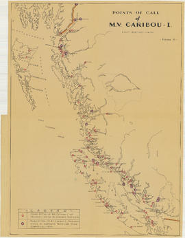
Points of call of M.V. Caribou I
Part of Gault Brothers fonds
Item is map of the British Columbia coast from Stewart to Victoria showing ports of call previously visited and ports of call not previously visited by the Caribou Shipping Company.

Part of Stuart Thomson fonds
![[Official party watching ship load at Alberta Wheat Pool]](/uploads/r/null/1/7/173eb9811fef5f9c3c4f1a4d790caba59ef12f948a557d7f0a274ff8b1c95d10/d637f57d-f404-4e58-9e99-c2ee5b0b8219-A00303_142.jpg)
[Official party watching ship load at Alberta Wheat Pool]
Part of Stuart Thomson fonds
![[Ship loading grain at Alberta Wheat Pool]](/uploads/r/null/b/6/b686d4fe567539be1f1efbb3c1521dcab2c75d462311f38cecf8ab2ac819798b/afaabb7a-a160-498a-a138-1eb7372a0d10-A00304_142.jpg)
[Ship loading grain at Alberta Wheat Pool]
Part of Stuart Thomson fonds

Part of Stuart Thomson fonds

Canadian Rugby Union tour to Japan - "Empress of Russia"
Part of Stuart Thomson fonds
![[View of C.P.R. Piers B and C]](/uploads/r/null/8/9/3/8931452dab0089e78e54e18fcde739897cf39f944d58741f92ba6c961e371714/0a725279-bcac-4fa2-9927-8794c8926ba0-CVA1477-38_142.jpg)
[View of C.P.R. Piers B and C]
Part of L.D. Taylor family fonds
Inscripton on verso of print reads:"Second largest pier in the world. Opened and dedicated by Louis D. Taylor, Mayor of Vancouver, July 4, 1927, Diamond Jubilee of Confederation."
![Loading flour [at] Terminal Dock](/uploads/r/null/1/c/1cf6ac27849ed77abd39a12535ef9fd2b221a00a79de0f47a607fcbe05733002/206a4ca4-ea69-48e0-9491-1fdbce5eaaf3-A06472_142.jpg)
Loading flour [at] Terminal Dock

Bird's Eye View - Vancouver Harbour B.C. Proposed Kitsilano Terminal and Free Port
Item is a mounted photographic copy of an aerial oblique perspective drawing of a proposed terminal and port facility located, but never built, at Kitsilano Point, Vancouver, B.C.
![Loading paper [onto ship in Ocean Falls]](/uploads/r/null/5/8/58bbfa248590f96dfaa667c066b7a2ce6c513c204f2a8423e32a385b8282274f/1b07ad4a-fecc-4f2c-ab0b-54577932c1b0-A03403_142.jpg)
Loading paper [onto ship in Ocean Falls]
![C.P.R. [crew] unloading freight](/uploads/r/null/7/4/744ff6f6d71d300e7ca6155f4a9bde244294f87f167dc51763f451e7d0c8ca8d/023eccba-e68a-44b5-862a-d871128d5b3f-A03387_142.jpg)
C.P.R. [crew] unloading freight
![[Crew] loading freight [on a] C.P.R. [ship]](/uploads/r/null/2/9/29754ba856a2b922b64ddd54871dbb8dcbc5c4be02c116936d7b679660d851f2/5efee222-5188-4347-b63d-3fcc7cbc6ec2-A07193_142.jpg)
[Crew] loading freight [on a] C.P.R. [ship]
![Loading paper [onto] S.S. "Prince George"](/uploads/r/null/3/0/30fefa9b00ce8aa9873c4a8b6039952e17539db202b97eefe700f43ebb687eb9/14440b51-d4af-43fb-9f9d-0ba7b8454fb8-A07299_142.jpg)
Loading paper [onto] S.S. "Prince George"

Loading paper onto S.S. "Prince George"

Loading paper into the hold of S.S. "Prince George"
Inscription on verso of print "Loading paper - SS Prince George / Ocean Falls, B.C."
![[Longshoremen loading ship at] Pacific Terminal](/uploads/r/null/0/9/0961c084c241fe6923a5a7d8426fdc301935f0979581103682b50c6c2c1e4e1a/95ef47be-d92c-42a7-8124-3b20b0c1b3d6-A15134_142.jpg)
[Longshoremen loading ship at] Pacific Terminal
![[Longshoremen loading ship at] Pacific Terminal](/uploads/r/null/9/2/925f55b220614f40f4864b0ca7a38ea1dfe8c4b81fd14dc75549a148314fcfae/a156ca10-3d53-4261-9a90-b38df23004ff-A15135_142.jpg)
[Longshoremen loading ship at] Pacific Terminal
![Loading flour [at] Terminal Dock](/uploads/r/null/c/8/c8ad098e97e0859172b04f1fa6804819cc4d1a7ab435118408fd7ff555559b67/9015b16c-ec19-4355-9e67-34d8a5212c89-A15282_142.jpg)
Loading flour [at] Terminal Dock

![St. Regis Paper Company [loading "Renown" Brand flour for export to China]](/uploads/r/null/7/a/7a410ca2ffd6c9fb342ba4880e2710c58b0cc922e91073d6f5e3a52888ccd8a5/56396574-66eb-43a2-98e0-f3270c46a603-A15406_142.jpg)
St. Regis Paper Company [loading "Renown" Brand flour for export to China]
![St. Regis Paper Company [loading "Renown" Brand flour for export to China]](/uploads/r/null/6/3/63a99ad1a1c4b2d7e710ec0c47e841143b8ea7592f5c74166cf118c1266b9cee/a932882c-6dc4-4fed-9e12-4cdb59e48ca1-A15407_142.jpg)
St. Regis Paper Company [loading "Renown" Brand flour for export to China]