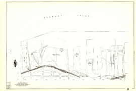
Showing 130 results

Archival description
City of Vancouver Archives technical and cartographic drawing collection Railroads With digital objects
Print preview View:

Map of Manitoba, Kewaydin, British Columbia and North West Territory shewing the country traversed by the Canadian Pacific Railway

Item is a map showing the extent of the Canadian Pacific Railway Company (C.P.R.) in Canada in 1883. Map shows boundaries, roads, trails, telegraph lines, towns, rivers, lakes and mountainous terrain in British Columbia, the North West Territory (Alberta, Athabasca, Saskatchewan, Assiniboia), Manitoba and Kewaydin, as well as some of Ontario and Western Quebec. Map is folded inside a book titled "North West Territory, Canada."

Vancouver, B.C. 1890 : built-on area

Item is a map showing downtown Vancouver and a portion of east Vancouver. City blocks, buildings and railway lines are shown. Annotations in pencil mark the location of Granville Bridge, Main Street Bridge, the Vancouver Lumber Company, the Canadian Pacific Railway station, the Hastings Sawmill, False Creek and Burrard Inlet.

Holdsworth, Derek

City of Vancouver [park sites June/80]

Map is a City Engineering Department base map of Vancouver, with parks hand-coloured in green. Shows city blocks and Canadian Pacific, Canadian National and Great Northern Railway lines. Golf courses, hospitals, schools, theatres and other structures are identified. "Metric Vancouver" and "Guide Map 15" appear in the bottom right corner of the map.

Cheakamus power survey for City of Vancouver, 1930-1931 : proposed storage reservoir at Daisy Lake : sheet no. 5 to accompany report of E.A. Cleveland dated November 30th 1931

Map is a plan of the proposed storage reservoir at Daisy Lake on the Cheakamus River. The map includes a plan of the topography of the proposed dam site, a log of borings, and a capacity diagram at Daisy Lake Reservoir. Also included are elevations, power stations, pipelines and the Pacific Great Eastern Railway line. The map was created to accompany E.A. Cleveland's "Report on a Preliminary Investigation of the Cheakamus River Power Possibilities made for the City of Vancouver." Map has been numbered Tube 58.

Cheakamus power survey for City of Vancouver, 1930-1931 : plan showing proposed development near Mile 19 - P.G.E. Rly. : sheet no. 6 to accompany report of E.A. Cleveland dated November 30th 1931

Map is a topographical plan showing the proposed hydroelectric development on the Cheakamus River near Mile 19, Pacific Great Eastern Railway. Indicated on the map are the locations of tunnels, dams, by-passes, pipelines, the railway line, and the power station for the Cheakamus Canyon development. The map was created to accompany E.A. Cleveland's "Report on a Preliminary Investigation of the Cheakamus River Power Possibilities made for the City of Vancouver." Map has been numbered Tube 59.

Cheakamus power survey for City of Vancouver, 1930-1931 : plan showing proposed diversion works near Mile 19 - P.G.E. Rly., detail sheet : sheet no. 7 to accompany report of E.A. Cleveland dated November 30th 1931

Map is a topographical plan showing the proposed diversion works on the Cheakamus River near Mile 19, Pacific Great Eastern Railway. Indicated on the map are the locations of tunnels, dams and the railway line. The map was created to accompany E.A. Cleveland's "Report on a Preliminary Investigation of the Cheakamus River Power Possibilities made for the City of Vancouver." Map is numbered Tube 60.

Cheakamus power survey for City of Vancouver, 1930-1931 : topographical plan from Alpha Lake to Cheakamus River, above Mile 34, P.G.E. Rly. : sheet no. 8 to accompany report of E.A. Cleveland dated November 30th 1931

Map is a topographical plan showing the area from Alpha Lake to Cheakamus River, above Mile 34, Pacific Great Eastern Railway. Indicated on the map are the locations of the Mons Gauging Site, a suggested dam site, trails, the old wagon road, the railway line, and Millar Creek. The map was created to accompany E.A. Cleveland's "Report on a Preliminary Investigation of the Cheakamus River Power Possibilities made for the City of Vancouver." Map has been numbered Tube 61.

Sheet 9 : Clark Drive to Slocan Street and Triumph Street to Charles Street

Item is a section showing the area from Clark Drive to Slocan Street and Triumph Street to Charles Street. Includes streets and roads, blocks, lots, legal descriptions, railways, parks, schools and drill hall. The Town of Hastings is indicated on the map.

Vancouver (B.C.). Office of the City Engineer

Sheet 11 : Carrall Street to Clark Drive and waterfront to Keefer Street

Item is a section showing the area from Carrall Street to Clark Drive and waterfront to Keefer Street. Includes streets and roads, blocks, lots, legal descriptions, railways, parks, schools, freight sheds, warehouses, piers and businesses along the waterfront.

Vancouver (B.C.). Office of the City Engineer

Sheet 16 : Maple Street to Oak Street and False Creek to Sixteenth Avenue

Item is a sectional map of the "Old City" of Vancouver showing Maple Street to Oak Street and False Creek to Sixteenth Avenue. Includes streets and roads, blocks, lots, legal descriptions, railways, schools and parks. Indicates crown land leased to the C.P.R. and other bodies.

Vancouver (B.C.). Office of the City Engineer

Sheet 7 : Clark Drive to Slocan Street and Seventh Avenue to Eighteenth Avenue

Item is a section showing the area from Clark Drive to Slocan Street and Seventh Avenue to Eighteenth Avenue. Includes streets and roads, blocks, lots, legal descriptions, railways, parks and schools. Some annotations have been made in green ink.

Vancouver (B.C.). Office of the City Engineer

Sheet 13 : Ontario Street to Clark Drive and First Avenue to Sixteenth Avenue

Item is a section showing the area from Ontario Street to Clark Drive and First Avenue to Sixteenth Avenue. Includes streets, roads, blocks, lots, legal descriptions, railways, parks and schools. Includes B.C. Electric Railway car barns. Annotations in pencil.

Vancouver (B.C.). Office of the City Engineer

Sheet 23 : Stanley Park to Granville Street and Robson Street to False Creek

Item is a section showing the area from Stanley Park to Granville Street and Robson Street to False Creek. Includes streets, roads and railways; blocks, lots and legal descriptions; as well as parks, schools, hospitals and churches. Shows the Burrard Bridge and C.P.R. property. Annotations in ink and pencil.

Vancouver (B.C.). Office of the City Engineer

Sheet G : Trafalgar Street to Granville Street and Sixteenth Avenue to Nanton Avenue

Item is a section showing the area from Trafalgar Street to Granville Street and Sixteenth Avenue to Nanton Avenue. Includes streets and roads; blocks, lots and legal descriptions; and parks, schools, railway lines and golf courses.

Vancouver (B.C.). Office of the City Engineer

Sheet S.V. 5 : Ash Street to St. George Street and Sixty-third Avenue to Fraser River

Item is a section showing the area from Ash Street to St. George Street and Sixty-third Avenue to Fraser River. Includes streets, roads, blocks, lots, legal descriptions, parks and railway lines.

Vancouver (B.C.). Office of the City Engineer

Sheet 30 : Maple Street to Oak Street and Fourteenth Avenue to Third Avenue and False Creek

Item is a section showing the area from Maple Street to Oak Street and Fourteenth Avenue to Third Avenue and False Creek. Includes streets, blocks, lots and legal descriptions, and the locations of parks, schools and railways.

Vancouver (B.C.). Engineering Services

Cheakamus power survey for City of Vancouver, 1930-1931 : plan showing topography southward along a line from Cheakamus River near Mile 34, P.G.E. Rly. : sheet no. 9 to accompany report of E.A. Cleveland dated November 30th 1931

Map is a topographical plan of the Cheakamus River area from a point southward near Mile 34, Pacific Great Eastern Railway, showing elevations and a trail. The map was created to accompany E.A. Cleveland's "Report on a Preliminary Investigation of the Cheakamus River Power Possibilities made for the City of Vancouver." Map has been numbered Tube 62.

Sheet 1: Slocan Street to Boundary Road and Triumph Street to Burrard Inlet

Item is a section showing the area bound by Slocan Street, Boundary Road, Triumph Street and the waterfront. Includes streets, roads, railways, blocks, lots, legal descriptions, quit claims, leases, parks and businesses along the waterfront.

Vancouver (B.C.). Office of the City Engineer

Sheet 10 : Clark Drive to Slocan Street and waterfront to Triumph Street

Item is a section showing the area from Clark Drive to Slocan Street and waterfront to Triumph Street. Includes streets and roads, blocks, lots, legal descriptions, railways, parks, boys' detention home and businesses along the waterfront. The Town of Hastings is indicated on the map.

Vancouver (B.C.). Office of the City Engineer

Sheet 19 : Maple Street to Richards Street and Drake Street to Third Avenue

Item is a section showing Maple Street to Richards Street and Drake Street to Third Avenue. Includes streets, roads, blocks, lots, legal descriptions, parks, schools, the Burrard and Granville Street Bridges, C.P.R. right-of-ways, the Squamish Band reserve, C.P.R. leases and property, and government reserve. Map includes Granville Island.

Vancouver (B.C.). Office of the City Engineer

Sheet G : Trafalgar Street to Granville Street and Sixteenth Avenue to Nanton Avenue

Item is a section showing the area from Trafalgar Street to Granville Street and Sixteenth Avenue to Nanton Avenue. Includes streets, roads and sewers; blocks, lots and legal descriptions; and parks, railway lines and schools.

Vancouver (B.C.). Office of the City Engineer

Sheet 6 : Knight Street to Slocan Street and Eighteenth Avenue to Twenty-ninth Avenue

Item is a section showing the area from Knight Street to Slocan Street and Eighteenth Avenue to Twenty-ninth Avenue. Includes streets and roads, blocks, lots, legal descriptions, railways, parks and schools. Some annotations have been made in pencil.

Vancouver (B.C.). Office of the City Engineer

Sheet 9 : Clark Drive to Slocan Street and Triumph Street to Charles Street

Item is a section showing the area from Clark Drive to Slocan Street and Triumph Street to Charles Street. Includes streets and roads, blocks, lots, legal descriptions, railways, parks, schools and drill hall. The Town of Hastings is indicated on the map.

Vancouver (B.C.). Office of the City Engineer

Sheet V and Z : Milton Street to Heather Street and Seventy-second Avenue to Fraser River ; Angus Drive to Granville Street and South West Marine Drive to Fraser River

Item is a sheet with two sections. The first section shows the area from Milton Street to Heather Street and Seventy-second Avenue to Fraser River; the second section shows the area from Angus Drive to Granville Street and South West Marine Drive to Fraser River. Sections show streets, roads, blocks, lots and legal descriptions, as well as the location of railway lines, the Eburne Sawmill, and a proposed bridge to Richmond.

Vancouver (B.C.). Office of the City Engineer

Sheet S.V. 9 : St. George Street to Argyle Street and Fifty-eighth Avenue to Fraser River

Item is a section showing the area from St. George Street to Argyle Street and Fifty-eighth Avenue to Fraser River. Includes streets, roads, blocks, lots, legal descriptions, railway lines, parks and schools.

Vancouver (B.C.). Office of the City Engineer

Sheet S.V. 10 : Dumfries Street to Fairmont Street and Twenty-seventh Avenue to Thirty-seventh Avenue

Item is a section showing the area from Dumfries Street to Fairmont Street and Twenty-seventh Avenue to Thirty-seventh Avenue. Includes streets, roads, blocks, lots, legal descriptions, railway lines, parks and schools. Annotations in green pencil.

Vancouver (B.C.). Office of the City Engineer

Sheet 32 : Main Street to Clark Drive and Sixteenth Avenue to Great Northern Way

Item is a section showing the area from Main Street to Clark Drive and Sixteenth Avenue to Great Northern Way. Includes streets, blocks, lots and legal descriptions, and the locations of parks, schools and railways.

Vancouver (B.C.). Engineering Services

Sheet 7 : Burrard Street to Main Street and Georgia Viaduct to Burrard Inlet

Item is a section showing the area from Burrard Street to Main Street and Georgia Viaduct to Burrard Inlet. Includes streets, blocks, lots and legal descriptions, and the locations of parks, beaches, schools, theatres, post office and Canadian Pacific Railway yards and piers.

Vancouver (B.C.). Engineering Services

Sheet 9 : Main Street to Clark Drive and Prior Street to Burrard Inlet

Item is a section showing the area from Main Street to Clark Drive and Prior Street to Burrard Inlet. Includes streets, blocks, lots and legal descriptions, and the locations of parks, schools, railways and piers along the waterfront.

Vancouver (B.C.). Engineering Services

Sheet 22 : Maple Street to Drake Street and Fourth Avenue to Thurlow Street

Item is a section showing the area from Maple Street to Drake Street and Fourth Avenue to Thurlow Street. Includes streets, blocks, lots and legal descriptions, and the locations of First Nations reserves, parks, railways and railway yards.

Vancouver (B.C.). Engineering Services

Sheet 40 : Inverness Street to Nanaimo Street and Twenty-second Avenue to Thirteenth Avenue

Item is a section showing the area from Inverness Street to Nanaimo Street and Twenty-second Avenue to Thirteenth Avenue. Includes streets, blocks, lots and legal descriptions, and the locations of parks, schools and railways.

Vancouver (B.C.). Engineering Services

Sheet 44 : Blenheim Street to Arbutus Street and King Edward Avenue to Fourteenth Avenue

Item is a section showing the area from Blenheim Street to Arbutus Street and King Edward Avenue to Fourteenth Avenue. Includes streets, blocks, lots and legal descriptions, and the locations of parks, schools and railways.

Vancouver (B.C.). Engineering Services

Results 1 to 50 of 130