![[View of 16th Avenue at Arbutus, looking east]](/uploads/r/null/5/a/9/5a970098dc3f7ec5ddb6a1eba0fedaed0bfff67cd6c7c167b1d90f204c8343a1/f190af08-2543-40e5-bd78-23f0a5951b30-CVA480-335_142.jpg)
[View of 16th Avenue at Arbutus, looking east]
- VPD-S214-: CVA 480-335
- Item
- [Mar. 1962]
[View of 16th Avenue at Arbutus, looking east]
![[View of intersection at 16th Avenue and Arbutus, looking west]](/uploads/r/null/7/2/e/72e1c1bcedc284d5a15cfcd4c780d96e74414174786caef96680d2bc81e6c17d/b883f78c-c99f-4822-8e1d-4dadbd84724e-CVA480-334_142.jpg)
[View of intersection at 16th Avenue and Arbutus, looking west]
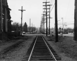
16th Avenue at Arbutus Street - Tracks looking south from north of 16th Avenue
![False Creek - Railway Embankment [3 of 3]](/uploads/r/null/c/7/c7113c95840569285da601cb075a796bfa281f1166b0f53a60887606f3ddd44f/849520db-bb0a-4be5-b3f9-ac3cf88bbdbb-A66398_142.jpg)
False Creek - Railway Embankment [3 of 3]
Part of City of Vancouver fonds
![False Creek - Railway Embankment [2 of 3]](/uploads/r/null/3/9/394dbf9c49676d4b4d8d4de6aa031e38e52f0b30bfa0b14b797ced9c14cc73e4/0293a4f3-c34d-487b-818c-8bbe00c1de2a-A66397_142.jpg)
False Creek - Railway Embankment [2 of 3]
Part of City of Vancouver fonds
![False Creek - Railway Embankment [1 of 3]](/uploads/r/null/d/9/d9a643481f6b33c2eff84aa7ea14a4fe633557ea38157f408e11a13f4cc42f9f/3e6aa5b8-7483-4b5b-b543-79f82d7c5f1a-A66396_142.jpg)
False Creek - Railway Embankment [1 of 3]
Part of City of Vancouver fonds
![Miscellaneous [68 of 130]](/uploads/r/null/7/1/71eb447ac97b8dd12a30ce2749b94af2887bb2c044536d599f677a9a487ace45/d11ca122-b806-4991-a03a-73938512db71-A64419_142.jpg)
Part of City of Vancouver fonds
![Miscellaneous [55 of 130]](/uploads/r/null/6/b/6b76a7bc9c11958ea03236273a346a2fdd7fcba56659419f85403323e3d40a45/4f238cee-3c9d-4aeb-b129-ea759db87fbb-A64386_142.jpg)
Part of City of Vancouver fonds
![Miscellaneous [54 of 130]](/uploads/r/null/9/0/903f6156f1812c4545deba0949b4c2b9ab99979ad25193013f5f329055368ba0/94bfc5e6-6b69-43d9-95c0-02654abd321e-A64385_142.jpg)
Part of City of Vancouver fonds
![Miscellaneous [53 of 130]](/uploads/r/null/0/6/06eae5eb055240bc3f25c814df29fc4e98ed13f96a078ed53b3aa631cbbbb5be/01da875c-4a64-476b-b225-1e6b6c125eb5-A64384_142.jpg)
Part of City of Vancouver fonds
![Miscellaneous [37 of 130]](/uploads/r/null/6/b/6b12f4534c38c24d4567db9adde3a59d2c84bea9a68facada78c66e2cea42bff/41931f04-548e-4b7c-9c69-214709d7a058-A64363_142.jpg)
Part of City of Vancouver fonds
![Miscellaneous [36 of 130]](/uploads/r/null/b/d/bd9d0b5a56996acdb17c3a4f17f5de6e7a4aaf9673aac419c294f3819d4094c9/8acbf1ad-e3c4-4d5c-b0c7-f4691d422009-A64359_142.jpg)
Part of City of Vancouver fonds
![Miscellaneous [35 of 130]](/uploads/r/null/7/5/7541e0eef4c4bc4969897b15b2e2cdd88df3138413d4d0176878b20dcec56b3e/db7a9559-37f0-4245-b666-0a0718df1f67-A64358_142.jpg)
Part of City of Vancouver fonds
![Miscellaneous [34 of 130]](/uploads/r/null/0/4/042ccff47bff4aaa681d0691dc975eef20f315514a52472a82f55384da0e8c9f/2033fddd-6b30-4278-8796-071a072f6dd8-A64357_142.jpg)
Part of City of Vancouver fonds
![[Underground railway tracks]](/uploads/r/null/5/4/5439f29b6743d86426dae5d15d29e545a67efad81cb117979d0ff71b78e34414/8e09c282-a1ec-4bd9-b8af-03ac32da8944-A16570_142.jpg)
Part of City of Vancouver fonds
![[Coal Harbour?]](/uploads/r/null/f/b/fb269570031b2a3828f329c97b9db78a5236f47cf4286fb78bf3c2058c53b0de/626b353c-ab4a-4c40-bcaf-41aaec70fe04-A16630_142.jpg)
Part of City of Vancouver fonds
Photograph shows waterfront with bridge, railway tracks and houses.
![[Northeast view of False Creek]](/uploads/r/null/c/b/cb30fde9722b8b64fd3b7e25f7487dfe9b743e7495319068d8ee15205635a8d1/982986e0-014c-4224-a34c-78e2d1d69b3f-A59369_142.jpg)
[Northeast view of False Creek]
Part of City of Vancouver fonds
![Trading scrap yard [at] Cordova St[reet]](/uploads/r/null/3/4/34810e915ef42c2f76a16f6333500154eb58648255e2ffd83f90faa653e9e221/bdb0a8be-b05c-4b27-88b3-b99382c73afd-A59202_142.jpg)
Trading scrap yard [at] Cordova St[reet]
Part of City of Vancouver fonds
Photograph also shows railroads and cars
![[Houses in Kitsilano]](/uploads/r/null/6/8/68f06ce6dde97dc34d6de508380ae6b1aa75c28f43f3ea4b0f58e46e584a4ef3/f61f1fae-b54c-4ae2-8b7f-18e22557f2be-A58936_142.jpg)
Part of City of Vancouver fonds
Photograph also shows a railway crossing
![[View of a railroad] looking East at Kerr [Street] and Kent [Avenue]](/uploads/r/null/4/d/4d9124902e1a1fa0e80bd739334b786f435286c4c008f415fe8492e8141b07aa/d70a3ab6-f5ff-4cd8-ad75-e6d320bb38ab-A58924_142.jpg)
[View of a railroad] looking East at Kerr [Street] and Kent [Avenue]
Part of City of Vancouver fonds

Part of City of Vancouver fonds

Part of City of Vancouver fonds
Item is a map showing the railway line from New Westminster to Point Grey. Railway data appears to have been added to a base map showing topographic contour lines, shorelines, low tide marks, natural divides, and municipal boundaries.

Profile Mile 27 to Mile 58 Port Mann Subdivision
Part of City of Vancouver fonds
Item is a profile of the Canadian Northern Railway right of way through the Fraser Valley.

Profile Mile 0 to Mile 27 Port Mann Subdivision
Part of City of Vancouver fonds
Item is a profile depicting the Great Northern Railway right of way in the Fraser Valley.

Hydro electric survey City of Vancouver : Cheakamus River system from Squamish River to Green River
Part of City of Vancouver fonds
Item is a map which shows a proposed hydro electric development of the Cheakamus River system from the Squamish River to Green Lake. The map includes proposed tunnel routes, diversions, storage reservoirs, dams, power houses, canals, and pipelines. Also shown are areas of suggested future development and the Pacific Great Eastern railway line. Included in the area surveyed are Garibaldi Lake, Starvation Lake, Deadman's Lake, Daisy Lake, Stoney Lake, Cheakamus Lake, Alta Lake, Nita Lake, Alpha Lake, and Green Lake, as well as the Squamish River, Pilchuk River, Cheakamus River, Soo River, Green River, and various creeks. Map is hand coloured with pencil annotations concerning watersheds, land height and creeks not included on the original map design.

Hydro electric surveys. Plan showing location of water powers investigated by City of Vancouver
Part of City of Vancouver fonds
Item is a map which shows the locations and the dates of use of "gauging stations established" and "city gauging stations still in use" in the area of south-western British Columbia where the City of Vancouver conducted hydro-electric surveys up to 1923.

Hydro electric surveys. Plan showing location of water powers investigated by City of Vancouver
Part of City of Vancouver fonds
Item is a map which functions as a visual index to the locations of various hydro electric surveys carried out by the City of Vancouver along the following rivers: Squamish River, Cheakamus River, Green River, Lillooet River, Eagle River, Indian River, Pitt River, Chehalis River, Harrison River, Chilliwack River, the Fraser and Thompson Rivers, and Bridge River. The map lists the names of the surveyors responsible and the areas covered by each survey. Annotations include the locations and the dates of use of "gauging stations established" and "city gauging stations still in use."

Sheet 16 : St. George Street to Argyle Street and Fifty-eighth Avenue to Fraser River
Part of City of Vancouver fonds
Item is a section showing the area from St. George Street to Argyle Street and Fifty-eighth Avenue to the Fraser River. Includes streets, roads, blocks, lots, legal descriptions, railway lines, parks and schools. Map is hand coloured to show tax sale property for sale, property with no water, street widening and drainage, replotting, reserved land for schools, reserved land for parks, sundry land, capital assets not including schools and parks, schools, and parks, as applicable.
Vancouver (B.C.). Office of the City Engineer

Sheet 15 : Ash Street to St. George Street and Fifty-eighth Avenue to Marine Drive
Part of City of Vancouver fonds
Item is a section showing the area from Ash Street to St. George Street and Fifty-eighth Avenue to Marine Drive.Includes streets, roads, blocks, lots, legal descriptions, parks and railway lines. Map is hand coloured to show tax sale property for sale, property with no water, street widening and drainage, replotting, reserved land for schools, reserved land for parks, sundry land, capital assets not including schools and parks, schools, and parks, as applicable. A note in ink at the top of the map indicates that "Brown-green refers to the Crippled Childrens Hospital Reserve."
Vancouver (B.C.). Office of the City Engineer

Sheet 14 : Ash Street to St. George Street and Marine Drive to Fraser River
Part of City of Vancouver fonds
Item is a section showing the area from Ash Street to St. George Street and Marine Drive to Fraser River. Includes streets, roads, blocks, lots, legal descriptions, parks and railway lines. Map is hand coloured to show tax sale property for sale, property with no water, street widening and drainage, replotting, reserved land for schools, reserved land for parks, sundry land, capital assets not including schools and parks, schools, and parks, as applicable.
Vancouver (B.C.). Office of the City Engineer

Sheet 6 : Craddock Street to Boundary Road and Twenty-ninth Avenue to Fortieth Avenue
Part of City of Vancouver fonds
Item is a section showing the area from Craddock Street to Boundary Road and Twenty-ninth Avenue to Fortieth Avenue. Includes streets, roads, blocks, lots, legal descriptions, parks. railway lines and schools. Map is hand coloured to show tax sale property for sale, property with no water, street widening and drainage, replotting, reserved land for schools, reserved land for parks, sundry land, capital assets not including schools and parks, schools, and parks, as applicable.
Vancouver (B.C.). Office of the City Engineer

Part of City of Vancouver fonds
Item consists of two sections on one sheet. Sections show the area from Milton Street to Heather Street and Seventy-second Avenue to Fraser River (Sheet Z) ; as well as Angus Drive to Granville Street and South West Marine Drive to Fraser River (Sheet V). Includes streets, roads, railway lines, blocks, lots and legal descriptions. Section is hand coloured to show tax sale property for sale, property with no water, street widening and drainage, replotting, reserved land for schools, reserved land for parks, sundry land, capital assets not including schools and parks, schools, and parks, as applicable.
Vancouver (B.C.). Office of the City Engineer

Sheet G : Trafalgar Street to Granville Street and Sixteenth Avenue to Nanton Avenue
Part of City of Vancouver fonds
Item is a section showing the area from Trafalgar Street to Granville Street and Sixteenth Avenue to Nanton Avenue. Includes streets, roads and sewers; blocks, lots and legal descriptions; and parks, railway lines and schools. Section is annotated to show tax sale property for sale, property with no water, street widening and drainage, replotting, reserved land for schools, reserved land for parks, sundry land, capital assets not including schools and parks, schools, and parks, as applicable.
Vancouver (B.C.). Office of the City Engineer

Sheet 23 : Stanley Park to Granville Street and Robson Street to False Creek
Part of City of Vancouver fonds
Item is a section showing the area from Stanley Park to Granville Street and Robson Street to False Creek. Includes streets, roads and railways; blocks, lots and legal descriptions; as well as parks, schools, hospitals and churches. Shows the Burrard Bridge and C.P.R. property. Map is hand coloured to show tax sale property for sale, property with no water, street widening and drainage, replotting, reserved land for schools, reserved land for parks, sundry land, capital assets not including schools and parks, schools, and parks, as applicable.
Vancouver (B.C.). Office of the City Engineer

Sheet 19 : Maple Street to Richards Street and Drake Street to Third Avenue
Part of City of Vancouver fonds
Item is a section showing Maple Street to Richards Street and Drake Street to Third Avenue. Includes streets, roads, blocks, lots, legal descriptions, parks, schools, the Burrard and Granville Street Bridges, C.P.R. right-of-ways, the Squamish Band reserve, C.P.R. leases and property, and government reserve. Map includes Granville Island. Map is hand coloured to show tax sale property for sale, property with no water, street widening and drainage, replotting, reserved land for schools, reserved land for parks, sundry land, capital assets not including schools and parks, schools, and parks.
Vancouver (B.C.). Office of the City Engineer

Sheet 16 : Maple Street to Oak Street and False Creek to Sixteenth Avenue
Part of City of Vancouver fonds
Item is a section showing Maple Street to Oak Street and False Creek to Sixteenth Avenue. Includes streets and roads, blocks, lots, legal descriptions, railways, schools and parks. Indicates crown land leased to the C.P.R. and other bodies. Map is hand coloured to show tax sale property for sale, property with no water, street widening and drainage, replotting, reserved land for schools, reserved land for parks, sundry land, capital assets not including schools and parks, schools, and parks.
Vancouver (B.C.). Office of the City Engineer

Sheet 13 : Ontario Street to Clark Drive and First Avenue to Sixteenth Avenue
Part of City of Vancouver fonds
Item is a section showing the area from Ontario Street to Clark Drive and First Avenue to Sixteenth Avenue. Includes streets, roads, blocks, lots, legal descriptions, railways, parks and schools. Includes B.C. Electric Railway car barns. Map is hand coloured to show tax sale property for sale, property with no water, street widening and drainage, replotting, reserved land for schools, reserved land for parks, sundry land, capital assets not including schools and parks, schools, and parks. Annotations in pencil.
Vancouver (B.C.). Office of the City Engineer

Sheet 12 : Ontario Street to Clark Drive and Keefer Street to Second Avenue
Part of City of Vancouver fonds
Item is a section showing the area from Ontario Street to Clark Drive and Keefer Street to Second Avenue. Includes streets, roads, blocks, lots, legal descriptions, railways, parks and schools. Includes Terminal Avenue and land used by the Great Northern Railway and the Canadian National Railway. Map is hand coloured to show tax sale property for sale, property with no water, street widening and drainage, replotting, reserved land for schools, reserved land for parks, sundry land, capital assets not including schools and parks, schools, and parks, as applicable.
Vancouver (B.C.). Office of the City Engineer

Sheet 11 : Carrall Street to Clark Drive and waterfront to Keefer Street
Part of City of Vancouver fonds
Item is a section showing the area from Carrall Street to Clark Drive and waterfront to Keefer Street. Includes streets and roads, blocks, lots, legal descriptions, railways, parks, schools, freight sheds, warehouses, piers and businesses along the waterfront.Map is hand coloured to show tax sale property for sale, property with no water, street widening and drainage, replotting, reserved land for schools, reserved land for parks, sundry land, capital assets not including schools and parks, schools, and parks, as applicable.
Vancouver (B.C.). Office of the City Engineer

Sheet 10 : Clark Drive to Slocan Street and Burrard Inlet to Triumph Street
Part of City of Vancouver fonds
Item is a section showing the area from Clark Drive to Slocan Street and aterfront to Triumph Street. Includes streets and roads, blocks, lots, legal descriptions, railways, parks, boys' detention home and businesses along the waterfront. The Town of Hastings is indicated on the map. Map is hand coloured to show tax sale property for sale, property with no water, street widening and drainage, replotting, reserved land for schools, reserved land for parks, sundry land, capital assets not including schools and parks, schools, and parks, as applicable.
Vancouver (B.C.). Office of the City Engineer

Sheet 9 : Clark Drive to Slocan Street and Triumph Street to Charles Street
Part of City of Vancouver fonds
Item is a section showing the area from Clark Drive to Slocan Street and Triumph Street to Charles Street. Includes streets and roads, blocks, lots, legal descriptions, railways, parks, schools and drill hall. The Town of Hastings is indicated on the map. Some annotations have been made in pencil. Map is hand coloured to show tax sale property for sale, property with no water, street widening and drainage, replotting, reserved land for schools, reserved land for parks, sundry land, capital assets not including schools and parks, schools, and parks, as applicable.
Vancouver (B.C.). Office of the City Engineer

Sheet 8 : McLean Drive to Slocan Street and William Street to Seventh Avenue
Part of City of Vancouver fonds
Item is a section showing the area from McLean Drive to Slocan Street and William Street to Seventh Avenue. Includes streets and roads, blocks, lots, legal descriptions, railways, parks, schools and some businesses. Map is hand coloured to show tax sale property for sale, property with no water, street widening and drainage, replotting, reserved land for schools, reserved land for parks, sundry land, capital assets not including schools and parks, schools, and parks, as applicable. Some annotations have been made in pencil.
Vancouver (B.C.). Office of the City Engineer

Sheet 7 : Clark Drive to Slocan Street and Seventh Avenue to Eighteenth Avenue
Part of City of Vancouver fonds
Item is a section showing the area from Clark Drive to Slocan Street and Seventh Avenue to Eighteenth Avenue. Includes streets and roads, blocks, lots, legal descriptions, railways, parks and schools. Map is hand coloured to show tax sale property for sale, property with no water, street widening and drainage, replotting, reserved land for schools, reserved land for parks, sundry land, capital assets not including schools and parks, schools, and parks, as applicable.
Vancouver (B.C.). Office of the City Engineer

Sheet 6 : Knight Street to Slocan Street and Eighteenth Avenue to Twenty-ninth Avenue
Part of City of Vancouver fonds
Item is a section showing the area from Knight Street to Slocan Street and Eighteenth Avenue to Twenty-ninth Avenue. Includes streets and roads, blocks, lots, legal descriptions, railways, parks and schools. Some annotations have been made in pencil. Map is hand coloured to show tax sale property for sale, property with no water, street widening and drainage, replotting, reserved land for schools, reserved land for parks, sundry land, capital assets not including schools and parks, schools, and parks. Map is hand coloured to show tax sale property for sale, property with no water, street widening and drainage, replotting, reserved land for schools, reserved land for parks, sundry land, capital assets not including schools and parks, schools, and parks, as applicable.
Vancouver (B.C.). Office of the City Engineer

Sheet 5 : Slocan Street to Boundary Road and Seventeenth Avenue to Twenty-ninth Avenue
Part of City of Vancouver fonds
Item is a section showing the area from Slocan Street to Boundary Road and Seventeenth Avenue to Twenty-ninth Avenue. Includes streets and roads, blocks, lots, legal descriptions, railways, parks, schools and the Vancouver Preventorium (for tuberculosis patients). Some annotations have been made in pencil. Map is hand coloured to show tax sale property for sale, property with no water, street widening and drainage, replotting, reserved land for schools, reserved land for parks, sundry land, capital assets not including schools and parks, schools, and parks, as applicable.
Vancouver (B.C.). Office of the City Engineer
Sheet 4 : Slocan Street to Boundary Road and Seventh Avenue to Seventeenth Avenue
Part of City of Vancouver fonds
Item is a section showing the area from Slocan Street to Boundary Road and Seventh Avenue to Seventeenth Avenue. Map is hand coloured to show tax sale property for sale, property with no water, street widening and drainage, replotting, reserved land for schools, reserved land for parks, sundry land, capital assets not including schools and parks, schools, and parks, as applicable. Includes streets and roads, blocks, lots, legal descriptions, railways, parks and schools.
Vancouver (B.C.). Office of the City Engineer

Sheet 1 : Slocan Street to Boundary Road and Triumph Street to Burrard Inlet
Part of City of Vancouver fonds
Item is a section showing the area bound by Slocan Street, Boundary Road, Triumph Street and the waterfront. Includes streets, roads, railways, blocks, lots, legal descriptions, quit claims, leases, parks and businesses along the waterfront. Section is annotated in colour to show tax sale property for sale, property with no water, street widening and drainage, replotting, reserved land for schools, reserved land for parks, sundry land, capital assets not including schools and parks, schools, and parks, as applicable.
Vancouver (B.C.). Office of the City Engineer

Sewerage system : plan of Point Grey Municipality
Part of City of Vancouver fonds
Item is a map annotated to show the sewer system in Point Grey. Base map was created by the Vancouver Map and Blue Print Co. and shows streets, railways, and district lot and block numbers.

Railroad tracks by West 6th Ave. and Heather St.
Photograph taken facing east.

Railroad tracks by West 6th Ave. and Heather St.
Photograph taken facing east. Billboards visible in background of photograph