Showing 604 results

Archival description
Railroads With digital objects
Print preview View:

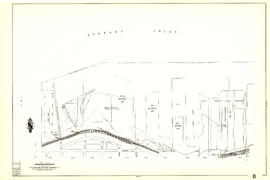
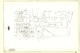
Sheet G : Trafalgar Street to Granville Street and Sixteenth Avenue to Nanton Avenue

Item is a section showing the area from Trafalgar Street to Granville Street and Sixteenth Avenue to Nanton Avenue. Includes streets and roads; blocks, lots and legal descriptions; and parks, schools, railway lines and golf courses.

Vancouver (B.C.). Office of the City Engineer

Sheet 84 : Laurel Street to Main Street and North Arm of Fraser River to Southwest Marine Drive

Item is a section showing the area from Laurel Street to Main Street and North Arm of the Fraser River to Southwest Marine Drive. Includes streets, blocks, lots and legal descriptions, and the location of the Canadian Pacific Railway line and yard.

Vancouver (B.C.). Engineering Services

Sheet 82 : Main Street to Tipping Road and Crompton Street and Twigg Island to Southeast Marine Drive

Item is a section showing the area from Main Street to Tipping Road and Crompton Street and Twigg Island to Southeast Marine Drive. Includes streets, blocks, lots and legal descriptions, and the location of the Canadian Pacific Railway.

Vancouver (B.C.). Engineering Services

Sheet 79 : Gladstone Street to Kerr Street and North Arm of Fraser River to Bobolink Avenue

Item is a section showing the area from Gladstone Street to Kerr Street and North Arm of Fraser River to Bobolink Avenue. Includes streets, blocks, lots and legal descriptions, and the locations of schools, golf courses and the Canadian Pacific Railway.

Vancouver (B.C.). Engineering Services

Sheet 78 : Kerr Street to Ivy Avenue and North Arm of Fraser River to Southeast Marine Drive

Item is a section showing the area from Kerr Street to Ivy Avenue and North Arm of Fraser River to Southeast Marine Drive. Includes streets, blocks, lots and legal descriptions, and the location of the Canadian Pacific Railway.

Vancouver (B.C.). Engineering Services

Sheet 70 : Macdonald Street to Cypress Street and Fifty-seventh Avenue to Forty-ninth Avenue

Item is a section showing the area from Macdonald Street to Cypress Street and Fifty-seventh Avenue to Forty-ninth Avenue. Includes streets, blocks, lots and legal descriptions, and the locations of golf courses, parks and railways.

Vancouver (B.C.). Engineering Services

Sheet 56 : Doman Street and Joyce Street to Boundary Road and Forty-ninth Avenue to Kingsway

Item is a section showing the area from Doman Street and Joyce Street to Boundary Road and Forty-ninth Avenue to Kingsway. Includes streets, blocks, lots and legal descriptions. Also included is Central Park and B.C. Electric Railway tracks in Burnaby.

Vancouver (B.C.). Engineering Services

Sheet 55 : Cecil Street and McHardy Street to Patterson Avenue and Kingsway to Monmouth Avenue and Price Street

Item is a section showing the area from Cecil Street and McHardy Street to Boundary Road and Kingsway to Monmouth Avenue and Price Street. Includes streets, blocks, lots and legal descriptions, and B.C. Electric Railway line. Also included are streets, blocks and B.C. Electric Railway line in the area from Boundary Road to Patterson Avenue in Burnaby.

Vancouver (B.C.). Engineering Services

Sheet 32 : Main Street to Clark Drive and Sixteenth Avenue to Great Northern Way

Item is a section showing the area from Main Street to Clark Drive and Sixteenth Avenue to Great Northern Way. Includes streets, blocks, lots and legal descriptions, and the locations of parks, schools and railways.

Vancouver (B.C.). Engineering Services

Sheet 33 : Clark Drive to Nanaimo Street and Thirteenth Avenue to Second Avenue

Item is a section showing the area from Clark Drive to Nanaimo Street and Thirteenth Avenue to Second Avenue. Includes streets, blocks, lots and legal descriptions, and the locations of parks, schools and railways.

Vancouver (B.C.). Engineering Services

Sheet 7 : Burrard Street to Main Street and Georgia Viaduct to Burrard Inlet

Item is a section showing the area from Burrard Street to Main Street and Georgia Viaduct to Burrard Inlet. Includes streets, blocks, lots and legal descriptions, and the locations of parks, beaches, schools, theatres, post office and Canadian Pacific Railway yards and piers.

Vancouver (B.C.). Engineering Services

Sheet 9 : Main Street to Clark Drive and Prior Street to Burrard Inlet

Item is a section showing the area from Main Street to Clark Drive and Prior Street to Burrard Inlet. Includes streets, blocks, lots and legal descriptions, and the locations of parks, schools, railways and piers along the waterfront.

Vancouver (B.C.). Engineering Services

Sheet 12 : Nanaimo Street to Cassiar Street and Pender Street to McGill Street

Item is a section showing the area from Nanaimo Street to Cassiar Street and Pender Street to McGill Street. Includes streets, blocks, lots and legal descriptions, and the locations of bridges, reservoirs and railways.

Vancouver (B.C.). Engineering Services

Sheet 20 : Main Street to Clark Drive and Great Northern Way to Prior Street

Item is a section showing the area from Main Street to Clark Drive and Great Northern Way to Prior Street. Includes streets, blocks, lots and legal descriptions, and the locations of parks, railways and railway yards.

Vancouver (B.C.). Engineering Services

Sheet 22 : Maple Street to Drake Street and Fourth Avenue to Thurlow Street

Item is a section showing the area from Maple Street to Drake Street and Fourth Avenue to Thurlow Street. Includes streets, blocks, lots and legal descriptions, and the locations of First Nations reserves, parks, railways and railway yards.

Vancouver (B.C.). Engineering Services

Sheet 30 : Maple Street to Oak Street and Fourteenth Avenue to Third Avenue and False Creek

Item is a section showing the area from Maple Street to Oak Street and Fourteenth Avenue to Third Avenue and False Creek. Includes streets, blocks, lots and legal descriptions, and the locations of parks, schools and railways.

Vancouver (B.C.). Engineering Services

Sheet 35 : Rupert Street to Ardley Avenue and Grandview Highway to Fifth Avenue

Item is a section showing the area from Rupert Street to Boundary Road and Grandview Highway to Fifth Avenue. Includes streets, blocks, lots and legal descriptions, and the locations of schools and railways. Also included are streets, blocks and railways in the area from Boundary Road to Ardley Avenue in Burnaby.

Vancouver (B.C.). Engineering Services

Sheet 39 : Kingsway and Nanaimo Street to Rupert Street and Ward Street to Twenty-second Avenue

Item is a section showing the area from Kingsway and Nanaimo Street to Rupert Street and Ward Street to Twenty-second Avenue. Includes streets, blocks, lots and legal descriptions, and the locations of parks, schools and railways.

Vancouver (B.C.). Engineering Services

Sheet 40 : Inverness Street to Nanaimo Street and Twenty-second Avenue to Thirteenth Avenue

Item is a section showing the area from Inverness Street to Nanaimo Street and Twenty-second Avenue to Thirteenth Avenue. Includes streets, blocks, lots and legal descriptions, and the locations of parks, schools and railways.

Vancouver (B.C.). Engineering Services

Sheet 44 : Blenheim Street to Arbutus Street and King Edward Avenue to Fourteenth Avenue

Item is a section showing the area from Blenheim Street to Arbutus Street and King Edward Avenue to Fourteenth Avenue. Includes streets, blocks, lots and legal descriptions, and the locations of parks, schools and railways.

Vancouver (B.C.). Engineering Services

Stuart's pocket map of Vancouver, B.C.

Item is an illustrated map of the "old" City of Vancouver. The map shows streets, transportation, and significant businesses (such as C.P.R. wharves, smelter, Hastings Mill, Morse's Mill, C.P.R. Shops, City Hospital, sawmill, slaughter houses, and smallpox hospital). The map includes "Index of Streets, Government Offices, Churches, [etc.], including "Civic and other Principal Buildings", "Places of Amusement or Recreation", "Public Schools", "Principal Mills, Foundries and Manufactories", "Principle Bankers", Principal Hotels", and "Miscellaneous".

The map was designed to be folded into a cover, which is included.

[Aerial view of Burrard Inlet, Hastings-Sunrise, Burnaby and the District of North Vancouver]

Photograph shows Exhibition Park and P.N.E. Golf Course, Second Narrows Bridge, New Brighton Park, Callister Park, Burrard Inlet, Lynn Creek, Lynn Park, Seymour Creek, Vancouver Harbour Commissioners Railway, Inspected Shingles Ltd., Cascade Rock and Gravel Co. Ltd., Canadian Shingle Co. Ltd. (Capilano Timber Co. Ltd.), Alberta Pool Elevator, Columbia Grain Elevator Co. Ltd., Canadian Pacific Railway, Girls Industrial School and Old Peoples Home sites.

[Aerial view of Burrard Inlet, Vancouver waterfront and North Vancouver waterfront]

Photograph shows L-R: Evans Coleman & Evans Warehouses, North Vancouver Ferry Wharf, Canadian National Steamships Pier, Canadian Fish Co., Ballantyne Pier, Great Northern Railway Pier and shed, Balfour Guthrie Freight shed, Pacific Mills Ltd., B.C. Sugar Refinery Co., Hastings Shingle Mills, LaPointe Pier B-C, Marine Engineering & Ship Builders Ltd., Terminal Dock & Warehouse and Burrard View Park.

Results 1 to 50 of 604