Sheet Z : Milton Street to Heather Street and Seventy-second Avenue to Fraser River ; Angus Drive to Granville Street and South West Marine Drive to Fraser River
Sheet V and Z : Milton Street to Heather Street and Seventy-second Avenue to Fraser River ; Angus Drive to Granville Street and South West Marine Drive to Fraser River
Sheet S.V. 9 : St. George Street to Argyle Street and Fifty-eighth Avenue to Fraser River
Sheet S.V. 5 : Ash Street to St. George Street and Sixty-third Avenue to Fraser River
Sheet S.V. 10 : Dumfries Street to Fairmont Street and Twenty-seventh Avenue to Thirty-seventh Avenue
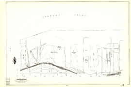
Sheet G : Trafalgar Street to Granville Street and Sixteenth Avenue to Nanton Avenue
Sheet G : Trafalgar Street to Granville Street and Sixteenth Avenue to Nanton Avenue
[Sheet 9 : Main Street to Clark Drive and Prior Street to Burrard Inlet]
Sheet 9 : Main Street to Clark Drive and Prior Street to Burrard Inlet
Sheet 9 : Clark Drive to Slocan Street and Triumph Street to Charles Street
Sheet 9 : Clark Drive to Slocan Street and Triumph Street to Charles Street
Sheet 84 : Laurel Street to Main Street and North Arm of Fraser River to Southwest Marine Drive
[Sheet 82 : Main Street to Tipping Road and Crompton Street and Twigg Island to Southeast Marine Drive]
Sheet 82 : Main Street to Tipping Road and Crompton Street and Twigg Island to Southeast Marine Drive
Sheet 8 : McLean Drive to Slocan Street and William Street to Seventh Avenue
Sheet 8 : McLean Drive to Slocan Street and William Street to Seventh Avenue
[Sheet 8 : Main Street to Clark Drive and Alexander Street to Burrard Inlet]
Sheet 8 : Main Street to Clark Drive and Alexander Street to Burrard Inlet
Sheet 79 : Gladstone Street to Kerr Street and North Arm of Fraser River to Bobolink Avenue
[Sheet 79 : Gladstone Street to Kerr Street and North Arm of Fraser River to Bobolink Avenue]
[Sheet 78 : Kerr Street to Ivy Avenue and North Arm of Fraser River to Southeast Marine Drive]
Sheet 78 : Kerr Street to Ivy Avenue and North Arm of Fraser River to Southeast Marine Drive
Sheet 70 : Macdonald Street to Cypress Street and Fifty-seventh Avenue to Forty-ninth Avenue
[Sheet 70 : Macdonald Street to Cypress Street and Fifty-seventh Avenue to Forty-ninth Avenue]
Sheet 7 : Clark Drive to Slocan Street and Seventh Avenue to Eighteenth Avenue
Sheet 7 : Clark Drive to Slocan Street and Seventh Avenue to Eighteenth Avenue
[Sheet 7 : Burrard Street to Main Street and Georgia Viaduct to Burrard Inlet]
Sheet 7 : Burrard Street to Main Street and Georgia Viaduct to Burrard Inlet
[Sheet 6 : Nicola Street to Beatty Street and English Bay Beach to Georgia Street]
Sheet 6 : Nicola Street to Beatty Street and English Bay Beach to Georgia Street
Sheet 6 : Knight Street to Slocan Street and Eighteenth Avenue to Twenty-ninth Avenue
Sheet 6 : Knight Street to Slocan Street and Eighteenth Avenue to Twenty-ninth Avenue
Sheet 6 : Craddock Street to Boundary Road and Twenty-ninth Avenue to Fortieth Avenue
[Sheet 56 : Doman Street and Joyce Street to Boundary Road and Forty-ninth Avenue to Kingsway]
Sheet 56 : Doman Street and Joyce Street to Boundary Road and Forty-ninth Avenue to Kingsway
[Sheet 55 : Cecil Street and McHardy Street to Patterson Avenue and Kingsway to Monmouth Avenue and Price Street]
Sheet 55 : Cecil Street and McHardy Street to Patterson Avenue and Kingsway to Monmouth Avenue and Price Street
Sheet 5 : Slocan Street to Boundary Road and Seventeenth Avenue to Twenty-ninth Avenue
Sheet 5 : Slocan Street to Boundary Road and Seventeenth Avenue to Twenty-ninth Avenue
Sheet 49 : Arbutus Street to Oak Street and Thirty-third Avenue to Laurier Avenue
Sheet 44 : Blenheim Street to Arbutus Street and King Edward Avenue to Fourteenth Avenue
[Sheet 44 : Blenheim Street to Arbutus Street and King Edward Avenue to Fourteenth Avenue]
[Sheet 40 : Inverness Street to Nanaimo Street and Twenty-second Avenue to Thirteenth Avenue]
Sheet 40 : Inverness Street to Nanaimo Street and Twenty-second Avenue to Thirteenth Avenue
Sheet 4 : Slocan Street to Boundary Road and Seventh Avenue to Seventeenth Avenue
Sheet 4 : Slocan Street to Boundary Road and Broadway to Seventeenth Avenue
Sheet 39 : Kingsway and Nanaimo Street to Rupert Street and Ward Street to Twenty-second Avenue


![[Sheet 9 : Main Street to Clark Drive and Prior Street to Burrard Inlet]](/uploads/r/null/c/a/ca4b4713bea0118fec812e6258afe5c1efa039db74073214703001a47b00f122/5e0d243a-99ae-42aa-8bb3-4a1abe9e1209-MAP339_142.jpg)


![[Sheet 8 : Main Street to Clark Drive and Alexander Street to Burrard Inlet]](/uploads/r/null/a/1/a10fe461f7836acc659d886d1888eef9d17bfc99d33e474c29ae025ed531b50c/e81d36a6-a6c1-40a5-852b-ef52bfbdb8dd-MAP339_142.jpg)

![[Sheet 79 : Gladstone Street to Kerr Street and North Arm of Fraser River to Bobolink Avenue]](/uploads/r/null/7/9/79214408afd85e4ab6ccc7eec43ecc85caf5ce5dedb9cfeb219866aa0091a733/7696de5a-3bba-4c2d-bc6c-83bf14bcf845-MAP339_142.jpg)
![[Sheet 78 : Kerr Street to Ivy Avenue and North Arm of Fraser River to Southeast Marine Drive]](/uploads/r/null/9/0/90c6186a1aa17588ec162078d412440a826f55dc10a9d49f8e74df97a4d3ff6e/0a3e4f49-3d6d-4dec-95f1-08aa42e666d8-MAP339_142.jpg)


![[Sheet 70 : Macdonald Street to Cypress Street and Fifty-seventh Avenue to Forty-ninth Avenue]](/uploads/r/null/f/9/f92d773f16070e3762b2b8519c7993087e55cec394d3c593367dd2f160a3e9ad/b01f6a8d-18a1-4872-b084-475fd79e81da-MAP339_142.jpg)


![[Sheet 7 : Burrard Street to Main Street and Georgia Viaduct to Burrard Inlet]](/uploads/r/null/c/d/cd235086cbaf81487b8784fb32b6ef913f4fe27305678cd1961adf506324c250/8f72f6bd-1013-48ad-a56c-e6269cb6f5a8-MAP339_142.jpg)

![[Sheet 6 : Nicola Street to Beatty Street and English Bay Beach to Georgia Street]](/uploads/r/null/f/2/f2effc97084427c0bd73bae3566d3ad910caaa6e7fb3e5ed9f3ece81bd2ac0a1/f2cc48a6-1195-4dd8-8227-71d36d1791bb-MAP339_142.jpg)


![[Sheet 56 : Doman Street and Joyce Street to Boundary Road and Forty-ninth Avenue to Kingsway]](/uploads/r/null/5/e/5ee0f6b78ce9f3b0e0e39795d6220cd37d587872bad7b41b67f4d29c7cb49d4c/f8a321d6-ea4f-4e1f-85da-6d12e149ea85-MAP339_142.jpg)


![[Sheet 44 : Blenheim Street to Arbutus Street and King Edward Avenue to Fourteenth Avenue]](/uploads/r/null/2/f/2fdf5060ec6fdc47756dc75416312dd42047abea2beed2d99f086c73bd0c8726/2fe0f45d-ad6c-46e6-9a9f-50c795523f5f-MAP339_142.jpg)
![[Sheet 40 : Inverness Street to Nanaimo Street and Twenty-second Avenue to Thirteenth Avenue]](/uploads/r/null/9/3/9367a0c50f6fa513d717a1972b1bac72acde6d41b002fefcf48ddbd8c8122e8a/c7bfac0b-bf44-441b-b059-fd7bbc0bd4a0-MAP339_142.jpg)


