![[A flat car on rails near Buntzen Lake]](/uploads/r/null/e/f/ef36a170a63a935a30c10ba410111411f26c6dee81f28781afc2c197c1dd0d07/f2d6e83d-addc-4d66-b8df-4a49f6da1031-A23290_142.jpg)
[A flat car on rails near Buntzen Lake]
- AM54-S4-1-S-4-: S-4-9
- Item
- [ca. 1902]
Part of Major Matthews collection
98 results with digital objects Show results with digital objects
[A flat car on rails near Buntzen Lake]
Part of Major Matthews collection
![[A railroad above a wagon road]](/uploads/r/null/5/6/1/5611125c0239a28ff429071c5e373a96c8c7e60a5ed0520f7f7594edb46a3bb0/7f3cef61-3a82-47d1-b07e-ccb3db87617d-CVA260-1111_142.jpg)
[A railroad above a wagon road]
Part of James Crookall fonds
![[An unidentified trestle bridge]](/uploads/r/null/3/9/39fdfa01a84339614eb65f280a452762a43e4d2ca6702d013f6aab7d6d942585/af3f3987-8c1b-41a5-a221-c2508a177dab-A62874_142.jpg)
[An unidentified trestle bridge]
Part of Major Matthews collection
![[An unidentified trestle bridge]](/uploads/r/null/e/b/eb0d4c8b0dae85193566cd43b486ff6bbfed301718582e19f02af491568cc2fb/0ad7459c-1972-4393-bca8-624dbe2c4fe4-A62875_142.jpg)
[An unidentified trestle bridge]
Part of Major Matthews collection

Part of Richard H. Trueman fonds
Image shows C.P.R. line to the left of the canyon.

Part of Richard H. Trueman fonds
Image shows C.P.R. line to the right of the canyon.

Part of Richard H. Trueman fonds
Image shows C.P.R. line and stone bridge to the left of the canyon.
Bird's eye view Lower Kicking Horse Canyon
Part of Major Matthews collection
Photograph shws bridge, railway tracks and river through canyon.
Bluffs, 2 1/2 miles above Yale looking down valley

Part of City of Vancouver Archives technical and cartographic drawing collection
Item is a map showing railway lines from Kamloops to the Vancouver, homesteads, lands disposed of by the provincial government, Indian reserves, forest reserves and parks, timber berths, grazing leases and land sales, land grants and mining land sales. Inset shows Vancouver Island and its railway line.
![[Buntzen Lake Dam under construction]](/uploads/r/null/8/9/89e05851fc9849500789e66325ccbb0dab13cebec4618829b8683b45363b0e5e/16b1c6e9-1b1d-4efe-9699-11f9b4398b52-A23315_142.jpg)
[Buntzen Lake Dam under construction]
Part of Major Matthews collection
![[Canadian Pacific rail line along the Fraser River]](/uploads/r/null/f/5/f5068a6b7c226036874b05895a1ce07e51790a03e2d69a53f27e91e33c04121d/ce9b2c39-5dcc-4d47-ada8-79bc292af478-A03866_142.jpg)
[Canadian Pacific rail line along the Fraser River]
Location may be near Hammond, B.C.

Part of Major Matthews collection

C.P.R. Bridge, White's Creek, Fraser Canyon
Part of Richard H. Trueman fonds

C.P.R. cantilever bridge across Fraser River 52 miles above Yale

C.P.R. cantilever bridge across Fraser River 52 miles above Yale

C.P.R. crossing Skuzzy River, Fraser Canyon
Part of Richard H. Trueman fonds
![[C.P.R. line through tunnels in mountain]](/uploads/r/null/f/8/f802e445bc29c0f27d847b0ce332297a0f6a0df7c77b32cf2de2d0c394b5f8b2/8905d2db-8786-4bc7-b04d-90363315a3f7-A07963_142.jpg)
[C.P.R. line through tunnels in mountain]
Part of Major Matthews collection

Part of William Orson Banfield fonds
![[Debris over railway tracks during flooding of the Fraser River]](/uploads/r/null/0/1/01847f2fb7d8caf15febc73957867715f62869873b9c8413e3569950b84d26cc/0815196e-62eb-4206-b7ca-06a285886f49-A60577_142.jpg)
[Debris over railway tracks during flooding of the Fraser River]
Part of Major Matthews collection
![[Debris over railway tracks during flooding of the Fraser River]](/uploads/r/null/9/0/90fe092f5f241878f2ae538a7a6cb1e5e2158fd5ec080a774b31604183fd14bf/81f35939-d5d7-4ee7-ab59-85ae9e5c4602-A60578_142.jpg)
[Debris over railway tracks during flooding of the Fraser River]
Part of Major Matthews collection

Part of Major Matthews collection
![Devil's Gap [and] Beaver Canyon View No. 2](/uploads/r/null/4/4/44d0528e595370f28fc2340079698113fd07efcd4c94dca50739bca01fccf576/c7c99282-4843-4adf-822c-539477e63eb9-A19771_142.jpg)
Devil's Gap [and] Beaver Canyon View No. 2
Part of Major Matthews collection
Photograph shows 5 men standing beside the canyon. The canyon is located in the Selkirk mountain range.
![[Driving the last spike of the Pacific Great Eastern Railway line 25 miles north of Horseshoe Bay]](/uploads/r/null/8/6/865249cd08465450446cf3fbba7cb5f3835813180d9172e6001e6fd65f64a12c/04e7f1a8-6f42-4a37-a8c0-632d0027d414-A37620_142.jpg)
[Driving the last spike of the Pacific Great Eastern Railway line 25 miles north of Horseshoe Bay]
Part of Major Matthews collection
Photograph shows Bill Smetanuch, Mr. Chetwynd and others
![[Elevated rails at the Buntzen Lake Dam construction site]](/uploads/r/null/9/9/99f876a0f7c5ea020f86be1134bd5ee9f41dbeefffe4a5bead61539e75c10301/df189970-2db0-4372-90fd-d40ff41ccf45-A23312_142.jpg)
[Elevated rails at the Buntzen Lake Dam construction site]
Part of Major Matthews collection

First Curve on Loop Going West, Selkirks
Part of Major Matthews collection
![[Floating rails on Buntzen Lake]](/uploads/r/null/9/4/94d3de2029b4cefd1b7c3546b7a0c026c33eb4536b25774518bee87d95505802/a703e912-68eb-465f-8c81-a88683ee637c-A23296_142.jpg)
[Floating rails on Buntzen Lake]
Part of Major Matthews collection
![[Flooding] East of Agassiz](/uploads/r/null/9/0/9026779ba4b27629323676cc03d3d37ba9282654f12d890d7d481a72c1b3b3cf/a825f68e-00ee-4198-8bc4-3ebef6aeb9b5-A33076_142.jpg)
Part of Major Matthews collection
Photograph shows men in a rowboat
![[Flooding] West of Harrison [River]](/uploads/r/null/1/5/1585f33739747cd7f7d0cdc779abda00522bfe13d09630d253e504b7de4b5752/3e0d9626-58af-4fb8-b92e-dbf04fd1ecc1-A33073_142.jpg)
[Flooding] West of Harrison [River]
Part of Major Matthews collection

Part of James Crookall fonds
![Harrison [River flood]](/uploads/r/null/e/7/e7e8221ae477cb44cccb068dd6aeca6b37be6c20182d659cbef886ad14593b9c/480e6c13-3fcc-4887-8b70-0341237bc377-A33074_142.jpg)
Part of Major Matthews collection

Hermit Range and snow sheds, from summit of Selkirks, C.P.R.
Part of Major Matthews collection
Photograph shows snow sheds and railway tracks in foreground, and mountain range in the distance.

Hermit Range from Snow Sheds, Selkirks
![Hermit Range, from summit of [Selkirks, C.P.R.]](/uploads/r/null/a/a/aaef5746df63939614fccd5d4a0c8a1417d3fa0c5dc24a6f2831154e619e4d52/e8367f9c-8d45-4d1b-8edf-37715a00045a-A07993_142.jpg)
Hermit Range, from summit of [Selkirks, C.P.R.]
Part of Major Matthews collection
J.S. Matthews' notes with print or negative in Archives.

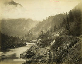
Illecillewaet Valley from Observation Point, Glacier, B.C.
Part of Richard H. Trueman fonds
Part of L.D. Taylor family fonds
Photograph shows the river, mountains and railroads

Part of Richard H. Trueman fonds
![Looking across Loop, Selkirk M[ountains]](/uploads/r/null/e/2/e275bb85c47afed5b2d207613d4e79766f9afed2a1edffc57266d6ae5f770c75/49b681b5-70aa-49af-8968-00e6144e138a-A19423_142.jpg)
Looking across Loop, Selkirk M[ountains]
Part of Richard H. Trueman fonds
![Loop, C.P.R. Selkirk M[oun]t[ain]s, showing four tracks](/uploads/r/null/b/0/b0a0cf5ee473bc74bbea9f30cb21753320f8c5e3dda92cf26b3f776daec2397e/22db0e41-8a5f-462f-9988-1bf40dfabcc6-A19463_142.jpg)
Loop, C.P.R. Selkirk M[oun]t[ain]s, showing four tracks
Part of Richard H. Trueman fonds
!["Loop," C.P.R., Selkirk M[ountains]](/uploads/r/null/9/4/9467229e1860d76119fc10341e39761633ad8c254f6a685743f7e26eb1fc49db/d8e72391-0290-4ea1-bc52-69429979a234-A19424_142.jpg)
"Loop," C.P.R., Selkirk M[ountains]
Part of Richard H. Trueman fonds

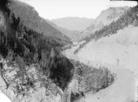
Lower Kicking Horse Canyon near Golden, B.C.
Part of Richard H. Trueman fonds
Image shows C.P.R. line to the left of the canyon.


Map of Manitoba, Keewatin, British Columbia, and North West Territory
Part of City of Vancouver Archives technical and cartographic drawing collection
Item is a map showing the route of the Canadian Pacific Railway through western Canada.

Part of City of Vancouver Archives technical and cartographic drawing collection
Item is a map showing the extent of the Canadian Pacific Railway Company (C.P.R.) in Canada in 1883. Map shows boundaries, roads, trails, telegraph lines, towns, rivers, lakes and mountainous terrain in British Columbia, the North West Territory (Alberta, Athabasca, Saskatchewan, Assiniboia), Manitoba and Kewaydin, as well as some of Ontario and Western Quebec. Map is folded inside a book titled "North West Territory, Canada."
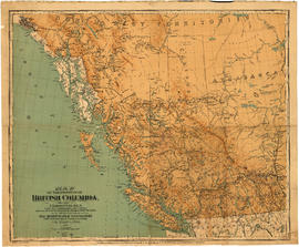
Map of the Province of British Columbia
Part of City of Vancouver Archives technical and cartographic drawing collection
Item is a a map of the province of British Columbia as well as parts of Alberta and the Northwest Territories. The map depicts the route of the Canadian Pacific Railway, including all the stations between Calgary and Vancouver. Also shown are the railways between Nanaimo and Victoria on Vancouver Island and between Edmonton and Calgary in Alberta

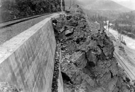
Part of Major Matthews collection
Photograph shows area known as the Big Slide, Kicking Horse River, the slopes of Mt. Field (on right) and Mt. Burgess in the background.

Mount Hermit Summit of Selkirks Height 9680 feet
Part of Major Matthews collection

Mount Hermit, C.P.R., Selkirks, Midwinter, Height 9680 feet
Part of Major Matthews collection
Photograph shows a snow shed
![Mount McDonald [MacDonald], C.P.R., Selkirks, midwinter, height 9440 ft.](/uploads/r/null/a/b/ab2a6f9761da72be5b95cc7c26b9134cbc9556ef110fbbd2a31bb79f4a574ee5/63e110ea-430d-46c2-add5-934dd2594853-A04166_142.jpg)
Mount McDonald [MacDonald], C.P.R., Selkirks, midwinter, height 9440 ft.
Part of Major Matthews collection
Photograph shows snow-covered railway tracks and shelter in foreground and mountain peak in the distance.

Part of William Orson Banfield fonds