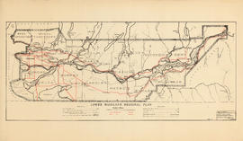
Showing 11 results

Archival description
Lower Mainland (B.C.) Item Railroads
Print preview View:

6 results with digital objects Show results with digital objects

Hydro electric surveys. Plan showing location of water powers investigated by City of Vancouver

Item is a map which functions as a visual index to the locations of various hydro electric surveys carried out by the City of Vancouver along the following rivers: Squamish River, Cheakamus River, Green River, Lillooet River, Eagle River, Indian River, Pitt River, Chehalis River, Harrison River, Chilliwack River, the Fraser and Thompson Rivers, and Bridge River. The map lists the names of the surveyors responsible and the areas covered by each survey. Annotations include the locations and the dates of use of "gauging stations established" and "city gauging stations still in use."

Railroads of the Lower Mainland of British Columbia

Primary map shows railroads, railroad names, subdivisions, spurs or yards, timetable station names, station buildings, absolute signals, signal identities, hot boxes and/or dragging equipment detectors, mileboards, bridges and interchanges in the Greater Vancouver area from West Vancouver in the north to the United States border in the south and from Haney in the east to Horseshoe Bay in the west. Ancillary maps show the B.C. Rail Squamish subdivision, the Vancouver B.N., C.N. and C.P. railroad yards, New Westminster C.N., C.P. and S.R.Y. railroad details, Burlington Northern Brunette details, the Canadian National Thornton Yard and Coquitlam C.P. details.

Railroads of the Lower Mainland of British Columbia, 1882-1992

Primary map shows existing track, abandoned track, station buildings and bridges in the Greater Vancouver area from West Vancouver in the north to the United States border in the south and from Haney in the east to Horseshoe Bay in the west. Ancillary maps show details of Vancouver B.C.E., C.No.P., C.P. and G.N. railroad yards and New Westminster B.C.E., C.No.P., C.P. details. The item also includes a chronology of railroad subsidiaries, takeovers and mergers.

Rights of way Vancouver and vicinity

Item is a portion of a topographical map of the Lower Mainland which has been extensively annotated to show the routes and rights-of-way of the various railways running through the region.

The lines shown are: Canadian Pacific Railway, Canadian National Railway, Great Northern Railway, B.C. Electric Railway, Canadian Pacific Railway operated by B.C. Electric Railway, Canadian Pacific Railway joint operation with National Harbours Board Terminal Railway, Great Northern Railway joint operation with National Harbours Board Terminal Railway, Great Northern Railway joint operation with Canadian National Railway, National Harbours Board Terminal Railway and Canadian Pacific Railway tunnel and Pacific Great Eastern Railway lease to National Harbours Board.

Composite industrial map of metropolitan area : Lower Mainland, British Columbia

Item is a map showing railroads, main traffic arteries, new housing developments, lot numbers, municipal boundaries and industrial areas in Vancouver, West Vancouver, North Vancouver, Coquitlam, Delta, Richmond and Surrey. Industrial areas are categorised according to the following: existing heavy industry, potential heavy industry, existing light industry and potential light industry. The item also includes a breakdown of industrial areas by acreages.