
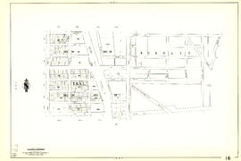
Sheet G : Trafalgar Street to Granville Street and Sixteenth Avenue to Nanton Avenue
- AM1594-MAP 682-: MAP 682.32
- Item
- [ca. 1925], with revisions to Jan. 29, 1952
Part of City of Vancouver Archives technical and cartographic drawing collection
Item is a section showing the area from Trafalgar Street to Granville Street and Sixteenth Avenue to Nanton Avenue. Includes streets and roads; blocks, lots and legal descriptions; and parks, schools, railway lines and golf courses.
Vancouver (B.C.). Office of the City Engineer


![City of Vancouver [park sites June/80]](/uploads/r/null/9/4/9484add7c4684ea3838e4d00ee8add3ecf85d78d5aa8fe2780cae273e59556a5/bd2464d8-2aa9-4501-aba6-8b3f7d130a42-MAP1032_142.jpg)


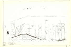
![Proposed Raymur Ave. [Avenue] Trunk Sewer diverting sewage from False Creek reclaimed area](/uploads/r/null/a/8/a8edd70876832fb32ffa8add8b5e261fe78b0e6efcb26d07a6fe1c74bf545b57/ac62eada-955d-4eee-8508-6bf4b71a21e5-MAP761_142.jpg)
![Proposed Raymur Ave. [Avenue] Trunk Sewer diverting sewage from False Creek reclaimed area](/uploads/r/null/5/2/5260099e92441f23442086ea3a8b5f7512bb5b4b4b5cbf554c9f13450bf4d37f/b5165f5d-bd82-46b5-9beb-0f969f7755ef-MAP761_142.jpg)
![Proposed Raymur Ave. [Avenue] Trunk Sewer diverting sewage from False Creek reclaimed area](/uploads/r/null/c/d/cddf61ac60b97b6fc54309ecbf8d1aea8e9aac3c672576fbd9953a05b82d42fc/14951fa4-0fd0-480c-a1f3-b7c2ef158398-MAP761_142.jpg)


