![[Map of Stanley Park]](/uploads/r/null/d/d/3/dd322a6761f1b4f031344f1ff63d5db1c74e4762d10a3efb119a67a8e9bd90af/27af3243-6183-4b63-b514-1415597e6c47-CVA1095-00630_142.jpg)
- COV-S644-: CVA 1095-00630
- Item
- Feb. 1974
Part of City of Vancouver fonds
Part of City of Vancouver fonds
![[Map of Stanley Park]](/uploads/r/null/9/2/f/92ff8e1d7d8890828829d6788574db4cda7b423aaa317ef08ec8594f81157c1e/ef3ec69f-74f3-440a-a83a-2097cfe0333b-CVA1095-00631_142.jpg)
Part of City of Vancouver fonds
![[Relief map of Vancouver and vicinity from A.R.P. headquarters]](/uploads/r/null/e/b/eb9fabcd34f3b0fb46820e6cb57b08f5b96f8a280edb5d316e0da81fcc9cbd68/442da9a4-6ef8-4eb2-8a41-40bb550e77ee-A11108_142.jpg)
[Relief map of Vancouver and vicinity from A.R.P. headquarters]

Four men studying a contour map
Part of Vancouver Express fonds

Image is of a map showing wind patterns.

Image is of a climate map of Europe.

Image is of a world map showing the equator and tropics.

Landscape - bedding and borders : perennial garden planning plan

Slide shows a world map of magnoliaceae distribution.

World distribution map- rhododendron
![Bioclimatic zones of British Columbia : [untitled]](/uploads/r/null/8/7/87a4500ea42de353c91d3db1fe86b64c946ecab4a332840dd69a7b6604d34b61/b7239821-cc65-45b5-97b8-03391075e97d-A52798_142.jpg)
Bioclimatic zones of British Columbia : [untitled]
Image shows map of British Columbia indicating Pacific Silver Fir zone.
![Bioclimatic zones of British Columbia : [untitled]](/uploads/r/null/9/9/99100498cf3a79f9c33aa194d61757054a371fca6abc7c81fce93a5c722dbf91/8dc2a5ed-0296-4d8f-831d-bca87d55d0ae-A52799_142.jpg)
Bioclimatic zones of British Columbia : [untitled]
Image shows map of British Columbia indicating Grand Fir zone.
![Bioclimatic zones of British Columbia : [untitled]](/uploads/r/null/5/f/5f0c04adfa96f5e11e8a961e226a8a2f783e0f98f300b874ca5e1565878062fc/1fd75a81-19ae-4efa-b11b-5916ee6d8717-A52800_142.jpg)
Bioclimatic zones of British Columbia : [untitled]
Image shows map of British Columbia indicating Subalpine Fir zone.
![Bioclimatic zones of British Columbia : [untitled]](/uploads/r/null/f/8/f88b50eda2acfcf7bbfc759a881a737f77a96b22e7cdbb251b49a8ce997ec3a2/f2684a4d-44b2-4e63-99c2-50cd35320c63-A52920_142.jpg)
Bioclimatic zones of British Columbia : [untitled]
Image shows map of British Columbia indicating Mountain Hemlock zone.
![Bioclimatic zones of British Columbia : [untitled]](/uploads/r/null/c/4/c44d3d5cbc59ab8a29d4a3d12cc116e5b8f9cfc262d7fb86c03b9ff1eb3c1a7f/b9ad283a-9182-4c06-bc1d-73fa879e6fff-A52921_142.jpg)
Bioclimatic zones of British Columbia : [untitled]
Image shows map of British Columbia indicating Western Hemlock zone.
![Bioclimatic zones of British Columbia : [untitled]](/uploads/r/null/f/8/f89f1d0dda7ec8d6af38ae328b79e5dfa984c7a912f21d0c3f97c02b34bed61a/d39501eb-d4e8-4ca5-ae42-724e470d20d2-A52922_142.jpg)
Bioclimatic zones of British Columbia : [untitled]
Image shows map of British Columbia indicating Black Spruce zone.
![Bioclimatic zones of British Columbia : [untitled]](/uploads/r/null/0/7/0799ddf27df56b7f54d46f0a98d8f6fbb9896c18f05264bd98647c5f0886569f/0798b86c-a083-4ab5-a826-89a51ab08424-A52923_142.jpg)
Bioclimatic zones of British Columbia : [untitled]
Image shows map of British Columbia indicating Engelmann Spruce zone
![Bioclimatic zones of British Columbia : [untitled]](/uploads/r/null/4/4/4454a24d5427a62d318cbff3564088b0000d509d6c750d2b4375f514d274b26f/4d955d7c-0ee8-48dc-aca9-e27efb176ee9-A52924_142.jpg)
Bioclimatic zones of British Columbia : [untitled]
Image shows map of British Columbia indicating Sitka Spruce zone.
![Bioclimatic zones of British Columbia : [untitled]](/uploads/r/null/8/9/898878e67d892ec6d406a1fee9ea2a1fca4e6cc821be7a3aeb6d5aa0966b0f3d/d8ae705c-5b3d-4fc6-9695-011507d8abd3-A52925_142.jpg)
Bioclimatic zones of British Columbia : [untitled]
Image shows map of British Columbia indicating White Spruce zone.
![Bioclimatic zones of British Columbia : [untitled]](/uploads/r/null/e/5/e5f0aaa7dad5ad336d3a33049fc236bd3eb557437a5f106dc3dff03f5c77bc5c/ff607f8a-bd6e-43f6-b425-f5b01a4ec5ec-A52926_142.jpg)
Bioclimatic zones of British Columbia : [untitled]
Image shows map of British Columbia indicating Lodgepole Pine zone.
![Bioclimatic zones of British Columbia : [untitled]](/uploads/r/null/1/e/1e3ff4fcdfd189e29582e417472f30285c4fa30c8ef9f63524ed928fafa15847/504fae3a-b24c-4ccc-a4e1-44f5ba9f0a2e-A52927_142.jpg)
Bioclimatic zones of British Columbia : [untitled]
Image shows map of British Columbia indicating Ponderose Pine zone.
![Bioclimatic zones of British Columbia : [untitled]](/uploads/r/null/c/a/ca31e349cd23e4b57a57e354bcd8912b0e792306c4a34172fcf4a63d8aaee8c1/212d7877-9bf9-4fd9-a446-6e3778771c78-A52928_142.jpg)
Bioclimatic zones of British Columbia : [untitled]
Image shows map of British Columbia indicating Western White Pine zone.
![Bioclimatic zones of British Columbia : [untitled]](/uploads/r/null/2/4/246e6ccf71a575d569ddd820218668215991f71ae66cd66a058c2eb6803d3752/5038be8a-2f9c-4b4f-8b5b-eeb940053dba-A52929_142.jpg)
Bioclimatic zones of British Columbia : [untitled]
Image shows map of British Columbia indicating Western Larch zone.
![Bioclimatic zones of British Columbia : [untitled]](/uploads/r/null/c/e/ce09451a470b9aad3e8f8d7c060691095c6bc3401a04b760bb984271df42a280/6640acc4-31f3-4de4-9cd0-10c055e6f0c9-A52930_142.jpg)
Bioclimatic zones of British Columbia : [untitled]
Image shows map of British Columbia indicating Tamarack zone.
![Bioclimatic zones of British Columbia : [untitled]](/uploads/r/null/f/4/f4f109363b1af3a3aefb8ba74da12dc8ad4eff7a21f230ce292bcdb47f64154a/8026fc01-9920-4588-9678-32be3ac25990-A52931_142.jpg)
Bioclimatic zones of British Columbia : [untitled]
Image shows map of British Columbia indicating Western Redcedar zone.
![Bioclimatic zones of British Columbia : [untitled]](/uploads/r/null/c/5/c55deb708855558f29e4792bc386176809c57927cbd6f6b0fb3b78855f868b8c/dc9a4bd0-947b-4b4a-9d52-d37ba26345e8-A52932_142.jpg)
Bioclimatic zones of British Columbia : [untitled]
Image shows map of British Columbia indicating Yellow Cedar zone.
![Bioclimatic zones of British Columbia : [untitled]](/uploads/r/null/f/f/ffca6547afc6b48a39a8b7b026429d566f4c2891c5ec5be64ac77bc2ee264902/b12eeb02-78d2-4289-81e0-afa42743cacf-A52933_142.jpg)
Bioclimatic zones of British Columbia : [untitled]
Image shows map of British Columbia indicating Mountain Alder zone.
![Bioclimatic zones of British Columbia : [untitled]](/uploads/r/null/f/8/f8cc3f20e15468425f787791faeb25d92e0088752800bce242e2ba24fed86594/fa7c84e0-f653-451b-bac9-0a2289877558-A52934_142.jpg)
Bioclimatic zones of British Columbia : [untitled]
Image shows map of British Columbia indicating Red Alder zone.
![Bioclimatic zones of British Columbia : [untitled]](/uploads/r/null/f/5/f518106bfcf4167ed64146ef3e81befd1cd1e7c6c702f89b4d1f0e2a5be6f4fc/d4dc5994-40a1-4371-bb6f-8c6360994cb8-A52935_142.jpg)
Bioclimatic zones of British Columbia : [untitled]
Image shows map of British Columbia indicating Arbutus zone.
![Bioclimatic zones of British Columbia : [untitled]](/uploads/r/null/0/1/0195206312d30f5401ca4cbea87e22f9958985950a053a3828428ec83f76f600/24ba8929-09a4-4c10-8c40-642f5e845016-A52936_142.jpg)
Bioclimatic zones of British Columbia : [untitled]
Image shows map of British Columbia indicating Garry Oak zone.
![Bioclimatic zones of British Columbia : [untitled]](/uploads/r/null/8/c/8ce30ea8b19ad17b6c1d1ee79122004f4398960c4aa80ef152cb3600017a6eef/75f7178b-1c48-4343-920e-f0903a8f1c9a-A52937_142.jpg)
Bioclimatic zones of British Columbia : [untitled]
Image shows map of British Columbia indicating Balsam Poplar/Black Cottonwood zone.
![Bioclimatic zones of British Columbia : [untitled]](/uploads/r/null/4/b/4b1828dc7109402949149416f8299ed8d7a4032c255b648656cd2554f092e6c0/098221d5-69ac-4209-a400-07895e2532d2-A52938_142.jpg)
Bioclimatic zones of British Columbia : [untitled]
Image shows map of British Columbia indicating Trembling Aspen zone.
![Bioclimatic zones of British Columbia : [untitled]](/uploads/r/null/3/d/3d78a2e2d68e1cb87cbd8a7df21828c1e7834fc299db2d88239cbc9c7e680b73/f0ef7044-d41c-4d53-b812-8f0166ff9b17-A52939_142.jpg)
Bioclimatic zones of British Columbia : [untitled]
Image shows map of British Columbia indicating paper birch zone.
![Bioclimatic zones of British Columbia : [untitled]](/uploads/r/null/7/8/78a19a3ef0758cb90604fa7c62cf4b9194656bd57b2d6fc391ce2f72a46613b6/4a306a8a-e8c5-4d8d-8b15-e4b8abbdba52-A52940_142.jpg)
Bioclimatic zones of British Columbia : [untitled]
Image shows map of British Columbia indicating Broadleaf Maple zone.
![Bioclimatic zones of British Columbia : [untitled]](/uploads/r/null/e/1/e1d3230495bfe1f7cd4ac108aa2c690a831ec9e2433b69c8bc4a740c2e1ad5a1/d5a4b679-864c-407f-86ad-0bc99e266e77-A52941_142.jpg)
Bioclimatic zones of British Columbia : [untitled]
Image shows map of British Columbia indicating Mountain Maple zone.
![Bioclimatic zones of British Columbia : [untitled]](/uploads/r/null/0/e/0e00c044711ef9502f35dce6bc492431a327d8058d2a8e2de0d6472cf72aa081/e004edf8-ca4b-4c2e-934a-0792cb57992c-A52942_142.jpg)
Bioclimatic zones of British Columbia : [untitled]
Image shows map of British Columbia indicating Vine Maple zone.
![Bioclimatic zones of British Columbia : [untitled]](/uploads/r/null/4/9/49faef2df5eeb134346dba56e4fc494982f543c57a02f6900163f984a5ea3c37/1065ed61-b306-4bd4-92b1-ef4098b161aa-A52943_142.jpg)
Bioclimatic zones of British Columbia : [untitled]
Image shows map of British Columbia indicating interior Douglas Fir zone.

Bio-geography - Hawaii : state of Hawaii
Image shows map of Hawaii.
![Bio-geography - Hawaii : [untitled]](/uploads/r/null/d/f/dfb467e7b3dc26bfffca9ea3a936a2b8ea1003c514207a79c23c8d2582e31021/d70f3dab-52f4-4dcb-9273-ac682b356981-A52948_142.jpg)
Bio-geography - Hawaii : [untitled]
Image shows map of Hawaii and Western North America.

Bio-geography - Hawaii : Kilauea Crater
Image shows map of Kilauea area.

Bio-geography - Hawaii : Kauai
Image shows map of Kauai.
![Bio-geography - Hawaii : [untitled]](/uploads/r/null/a/9/a9c37c3cb14cc9225025b3de7911fa327f4f8856938873728e672a64044e19c1/3f2e31ba-e405-4421-95e3-c2eae6836c68-A52951_142.jpg)
Bio-geography - Hawaii : [untitled]
Image shows map of Hawaii.
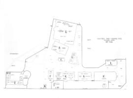
Item is a photographic reproduction of a drawing depicting the site map for the buildings used as a clearing station by the federal government at Hastings Park as part of the uprooting and mass displacement of Japanese Canadians.

Plan of the Vancouver Exhibition Grounds 1915
Item is a print made from a photographic negative in the holdings of the City of Vancouver Archives. The original map is annotated "1915" in the hand of J.S. Matthews.

People viewing Challenger relief map of British Columbia in P.N.E. B.C. Building

People viewing Challenger relief map of British Columbia in P.N.E. B.C. Building

People viewing Challenger relief map of British Columbia in P.N.E. B.C. Building

People viewing Challenger relief map of British Columbia in P.N.E. B.C. Building

People viewing Challenger relief map of British Columbia in P.N.E. B.C. Building

People viewing Challenger relief map of British Columbia in P.N.E. B.C. Building