![Infrastructure and 1987-1990 Capital [138 of 138]](/uploads/r/null/4/a/4a9066783f8f279014d2a1f729e8f4a0d3b08d1c02d12d98c83bd914e6979716/4fd54642-02f9-45db-a26c-c97466699ba0-A69073_142.jpg)
Infrastructure and 1987-1990 Capital [138 of 138]
- COV-S663-: CVA 800-4800
- Item
- Oct. 1, 1985
Part of City of Vancouver fonds
Infrastructure and 1987-1990 Capital [138 of 138]
Part of City of Vancouver fonds
![Infrastructure and 1987-1990 Capital [137 of 138]](/uploads/r/null/4/6/4630678e4119949c579d8ba2bc88a325307ea8a309ea9def2eaf24cccf63004c/dc1b84a7-620e-437b-94bd-e279d2a4238d-A69070_142.jpg)
Infrastructure and 1987-1990 Capital [137 of 138]
Part of City of Vancouver fonds
![WHC APWA [American Public Works Association?] Presentation [28 of 32]](/uploads/r/null/6/9/697e466003fd4a3124203be888e8df7d39204e1605aa2589a7c2feac56020cb8/02b4a105-d352-4e4c-abeb-5de395cb8618-A69003_142.jpg)
WHC APWA [American Public Works Association?] Presentation [28 of 32]
Part of City of Vancouver fonds
![Infrastructure and 1987-1990 Capital [38 of 138]](/uploads/r/null/a/f/afa4ec738793aea79f7d24124b5465d9290e63b5865263f853345efae762e252/f13b3e4e-971b-4f0d-958c-84ad1fe69d70-A67059_142.jpg)
Infrastructure and 1987-1990 Capital [38 of 138]
Part of City of Vancouver fonds
![Infrastructure and 1987-1990 Capital [15 of 138]](/uploads/r/null/8/9/890fd434296fdb91a1654bf61d8cbd9fddc2736548f4d738957466e91430c487/7395426e-e47d-41eb-b40a-3e738d3cd515-A67036_142.jpg)
Infrastructure and 1987-1990 Capital [15 of 138]
Part of City of Vancouver fonds
![Infrastructure and 1987-1990 Capital [14 of 138]](/uploads/r/null/d/8/d84d6ca9c9c6783d589d7d980c19827f1731237ab9cc096b92199f22262e3170/29bd2e10-ff68-4115-bc71-85d4cdd251e6-A67035_142.jpg)
Infrastructure and 1987-1990 Capital [14 of 138]
Part of City of Vancouver fonds
![Infrastructure and 1987-1990 Capital [13 of 138]](/uploads/r/null/f/3/f3e64eecf9b0b8673f41b897c50a55ced76355e4d498d7666f3438ca1b202f6c/8b2c797c-91a4-4d18-a186-4e0f586c239e-A67034_142.jpg)
Infrastructure and 1987-1990 Capital [13 of 138]
Part of City of Vancouver fonds
![Infrastructure and 1987-1990 Capital [12 of 138]](/uploads/r/null/7/b/7be6e4dad3887d6d8609081c5cab0e4e7dad080287edb3d2350d57fca7a1ef9f/51a4fd50-ffac-4b08-8fc6-2e9660c898a2-A67033_142.jpg)
Infrastructure and 1987-1990 Capital [12 of 138]
Part of City of Vancouver fonds
![Infrastructure and 1987-1990 Capital [11 of 138]](/uploads/r/null/1/e/1e70482c94650adfc0b7bcda68c3928fc05399836ae66ee0dfa10c0887a1c4d4/87be7b8f-0347-4828-8ad8-55fe9b385e97-A67032_142.jpg)
Infrastructure and 1987-1990 Capital [11 of 138]
Part of City of Vancouver fonds
![Infrastructure and 1987-1990 Capital [10 of 138]](/uploads/r/null/8/e/8e6da3a9ddf37310f352172a6ba693e0c21f0c2751dbf6286de69ad4fe368201/11b3f9f2-8f2f-45c5-bd54-429e5ca3dab1-A67031_142.jpg)
Infrastructure and 1987-1990 Capital [10 of 138]
Part of City of Vancouver fonds
![Infrastructure and 1987-1990 Capital [6 of 138]](/uploads/r/null/2/8/28ea66408b775a585d7eef0a68177ab8a1bde6251ac8ad0b4bcb8a616b26d3e4/c99aa15f-a55e-4599-91a8-b630c01944cd-A67010_142.jpg)
Infrastructure and 1987-1990 Capital [6 of 138]
Part of City of Vancouver fonds
![North Portal Dunsmuir Tunnel [3 of 3]](/uploads/r/null/6/d/6d5a82659d6b11e2e3a1456df7e738100bc56b3439a62918e1e4b0c7eb5ed926/43d3d188-0aa7-48a8-8e0e-58f8f9828964-A66677_142.jpg)
North Portal Dunsmuir Tunnel [3 of 3]
Part of City of Vancouver fonds
![North Portal Dunsmuir Tunnel [2 of 3]](/uploads/r/null/e/1/e138164f03396140e2d98b50c56affbb9d7d7121bb6b0851ba5dbbd57ee61613/82cadf77-9465-4b61-a68e-59202620e921-A66676_142.jpg)
North Portal Dunsmuir Tunnel [2 of 3]
Part of City of Vancouver fonds
![North Portal Dunsmuir Tunnel [1 of 3]](/uploads/r/null/1/f/1f999736dc5ea4b22b4133cda60c20ab5cce87cc251dde7c9f555ddc4d071e22/67a18b7e-4a68-44b4-b5a5-33fd3496df6b-A66675_142.jpg)
North Portal Dunsmuir Tunnel [1 of 3]
Part of City of Vancouver fonds
![Burrard Viaduct Construction [10 of 10]](/uploads/r/null/1/f/1feb3308ec3074da234277c232c771cbc21268c6c18cb278a844a9bc4fce07f4/cb3c6a4b-0bc3-4517-a35a-ed34c7f38768-A66674_142.jpg)
Burrard Viaduct Construction [10 of 10]
Part of City of Vancouver fonds
Image shows Dunsmuir Tunnel north portal.
![Burrard Viaduct Construction [9 of 10]](/uploads/r/null/e/3/e320a0d71ff665ba99ad1bae430f8072a666826f6243a4ea1ae636b4dc9426f6/4ceb69f9-a422-48e4-b0d3-be103c0c5a09-A66673_142.jpg)
Burrard Viaduct Construction [9 of 10]
Part of City of Vancouver fonds
Image shows view of ramp west of Burrard.
![Burrard Viaduct Construction [8 of 10]](/uploads/r/null/1/5/1576a1835424b279c464d30bda8a38c8692e090e5ddb14622b234bf70994bea0/fe0c75df-a5b8-4c9b-a0f8-ab257e381e57-A66672_142.jpg)
Burrard Viaduct Construction [8 of 10]
Part of City of Vancouver fonds
Image shows view of ramp west of Burrard.
![Burrard Viaduct Construction [7 of 10]](/uploads/r/null/c/3/c386150adf86440147b0dc6851f21d648c378181517ca31d19e327e7c8bc4d3d/fcfbf86d-f5b0-48e1-a7de-3973a3f23517-A66671_142.jpg)
Burrard Viaduct Construction [7 of 10]
Part of City of Vancouver fonds
Image shows view of ramp west of Burrard.
![Burrard Viaduct Construction [6 of 10]](/uploads/r/null/e/2/e2bc62eb49850bac96fb44d464d7c3b7428935170799293b1425bfe62a88ddf9/ad52a655-87b5-49a0-9fb3-4c89ddc22e9b-A66670_142.jpg)
Burrard Viaduct Construction [6 of 10]
Part of City of Vancouver fonds
Image shows view of ramp west of Burrard.
![Burrard Viaduct Construction [5 of 10]](/uploads/r/null/b/d/bd8e31836bf52c37b475510c8d189a4feb5a1d681478a69c03490442b6f69daa/2f43f974-f3e2-41bb-96a0-265549b39bcb-A66669_142.jpg)
Burrard Viaduct Construction [5 of 10]
Part of City of Vancouver fonds
Picture shows construction of the Burrard Viaduct.
![Burrard Viaduct Construction [4 of 10]](/uploads/r/null/d/f/df63d5d41d2efd768757d33c9437aaeffa534cd45ee5e6819c5c11c849371780/a283b610-c90e-466d-ab95-19761819fe03-A66668_142.jpg)
Burrard Viaduct Construction [4 of 10]
Part of City of Vancouver fonds
Picture shows construction of the Burrard Viaduct.
![Burrard Viaduct Construction [3 of 10]](/uploads/r/null/1/3/13457fb6c034f66e12081cac188b2293e5b9ab27df41cca0be02aaff9365bf5a/eb76d772-360e-40dd-b641-16f0f06f25c5-A66667_142.jpg)
Burrard Viaduct Construction [3 of 10]
Part of City of Vancouver fonds
Image shows Burrard Viaduct and ramp.
![Waterfront Viaduct Construction [11 of 11]](/uploads/r/null/d/8/d8f0e5175946f7302863b47502e512fe86ba732ed39aff9bc82ccfb3569c9b66/a547d297-a96f-4148-8289-17e0e5bd848c-A66666_142.jpg)
Waterfront Viaduct Construction [11 of 11]
Part of City of Vancouver fonds
View looking east on Cordova Street showing part of the Canadian Pacific Railway Station.
![Waterfront Viaduct Construction [10 of 11]](/uploads/r/null/2/3/23793299679001ba0bf49a9a387b2cc6520b2269d1f95dac5ac34c019126d916/c8607500-3b77-4d4f-aa53-782029dcb120-A66665_142.jpg)
Waterfront Viaduct Construction [10 of 11]
Part of City of Vancouver fonds
View looking east on Cordova Street showing part of the Canadian Pacific Railway Station.
![Waterfront Viaduct Construction [9 of 11]](/uploads/r/null/e/7/e7ac88ab9ecd750d0bda975f1068c864e0c0f0183c01068f8a0a3be71e61ef6c/172a8c22-6aae-4ab2-be73-edc0097e4351-A66664_142.jpg)
Waterfront Viaduct Construction [9 of 11]
Part of City of Vancouver fonds
![Waterfront Viaduct Construction [8 of 11]](/uploads/r/null/7/d/7d5aa6e7c4b7e86721688fe63368eb0db52f69e9765d74719ae3d323772163c2/e4cd15d2-143d-4efc-bec9-b76b0b0a29c7-A66663_142.jpg)
Waterfront Viaduct Construction [8 of 11]
Part of City of Vancouver fonds
![Waterfront Viaduct Construction [7 of 11]](/uploads/r/null/4/8/48bb194b34e00b0cad3d1d2543e54903a359972dd23d5e0ce195b4510e9d1a00/e7c484a8-9ba3-4dd3-8cf6-eb7235797862-A66662_142.jpg)
Waterfront Viaduct Construction [7 of 11]
Part of City of Vancouver fonds
![Waterfront Viaduct Construction [6 of 11]](/uploads/r/null/c/c/ccc82e693fbbf4e30d77fb2748e694474b24cbbf25b24776cba5a19d7124dd97/c22197ef-965f-46c9-a97c-cf2c99ed450b-A66661_142.jpg)
Waterfront Viaduct Construction [6 of 11]
Part of City of Vancouver fonds
![Waterfront Viaduct Construction [5 of 11]](/uploads/r/null/8/7/87c13a9be5aeefe66e653a33dcf4cb6589bb6e17fb788eaff3ce7522279c044e/9f1baff2-ac15-4ada-b2e4-a070366e623f-A66660_142.jpg)
Waterfront Viaduct Construction [5 of 11]
Part of City of Vancouver fonds
Image shows view along Waterfront to Burrard Viaduct.
![Waterfront Viaduct Construction [4 of 11]](/uploads/r/null/c/c/cc6ef3e507425de63a30a19f97105563e03d4def386679da3c430530f518a2b5/6fe8d857-5ba7-4162-8da7-d67370ff2225-A66659_142.jpg)
Waterfront Viaduct Construction [4 of 11]
Part of City of Vancouver fonds
Photograph shows a view looking east on Cordova Street, the Canadian Pacific Railway Station and the Woodward's tower.
![Waterfront Viaduct Construction [3 of 11]](/uploads/r/null/8/6/86c37065ad3217098eaac229770999464a5c4f5b2ad938f631c90461d603ec22/80fdee2f-b19c-4425-af9a-559921004967-A66658_142.jpg)
Waterfront Viaduct Construction [3 of 11]
Part of City of Vancouver fonds
Photograph shows a view looking east on Cordova Street, the Canadian Pacific Railway Station and the Woodward's tower.
![Waterfront Viaduct Construction [2 of 11]](/uploads/r/null/7/b/7b508cf464ba9a0e863b133b981b8e0d0a08898814b8ac078fd77e612b8afb9d/a992aab2-7ffe-404a-8f8c-0a4449a62da2-A66657_142.jpg)
Waterfront Viaduct Construction [2 of 11]
Part of City of Vancouver fonds
Photograph shows the Canadian Pacific Railway Station.
![Waterfront Viaduct Construction [1 of 11]](/uploads/r/null/c/1/c1286548821ae99ba9e318bc6608f7824229b726c6fa995fb9ed376d045479d2/b40ef04a-abbc-4f34-a1c3-1dd8e4c0f2a2-A66656_142.jpg)
Waterfront Viaduct Construction [1 of 11]
Part of City of Vancouver fonds
Photograph shows the Canadian Pacific Railway Station.
![Pender St. Wood Block Repairs [Pender and Main]](/uploads/r/null/2/1/212703d3b9803e43271ed762015237916a5209958530fbe1cd47c06e9b4e6713/0176bf29-0f51-476b-b04a-aae5db8c4187-A16605_142.jpg)
Pender St. Wood Block Repairs [Pender and Main]
Part of City of Vancouver fonds
![Pender St. Wood Block Repairs [Pender and Main]](/uploads/r/null/5/2/520f40ba47555e5b262c5d41b855393618b362e1457bf3df9a5d1577f98af395/ebd1ab16-813e-43ed-b824-d2911513455f-A16604_142.jpg)
Pender St. Wood Block Repairs [Pender and Main]
Part of City of Vancouver fonds

Demolition of the "old" Georgia Viaduct
Part of City of Vancouver fonds
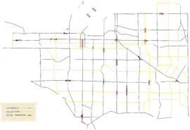
City of Vancouver zoning map : Mylar overlay
Part of City of Vancouver fonds
Part is a transparent overlay indicating arterial roads, collector roads, and retail frontage in Vancouver when used in conjunction with base map COV-S445-3-: MAP 714-: LEG1698.1.

Part of City of Vancouver fonds
Part is a base map showing zoning districts, streets, schools, parks, and golf courses, and includes a table of building lines as contained in Schedule "E" to By-law no. 3575.

Part of City of Vancouver fonds
Item is a map composed of a base map and a mylar overlay. Base map shows zoning districts, streets, schools, parks, and golf courses, and includes a table of building lines as contained in Schedule "E" to By-law no. 3575. The Mylar overlay shows arterial roads, collector roads, and retail frontage.

Vancouver, as seen from Hotel Vancouver
Part of Major Matthews collection
Photograph shows the buildings under construction on the east side of the 600 Block of Granville Street including the New York Block
![[The reconstruction of Granville Street looking north from Pender Street]](/uploads/r/null/2/7/27036b726860acf23e20f6d18205af610d11748238f91ddd972b5b468089a4c4/dc9a618a-dd92-439d-bdfb-b59bc4d491ef-A37243_142.jpg)
[The reconstruction of Granville Street looking north from Pender Street]
Part of Major Matthews collection

Part of Major Matthews collection
Photograph shows the Donald A. Smith (Strathcona) building under construction and the first Hotel Vancouver

Part of Major Matthews collection

Part of Major Matthews collection
![[The bituminous macadam being repaired on Cambie Street between 10th Avenue and 12th Avenue]](/uploads/r/null/5/b/5bc4f60e8b1201f226b1e6e33a05b46cb199367aa4738ce451394ac4e21fed6c/520fbfd3-7e85-47bf-b790-fef5f90d9726-A37140_142.jpg)
[The bituminous macadam being repaired on Cambie Street between 10th Avenue and 12th Avenue]
Part of Major Matthews collection
![[The bituminous macadam being repaired on Cambie Street between 10th Avenue and 12th Avenue]](/uploads/r/null/e/8/e85e7d61fa61c2874e0b3f8720012ea58a572a4d7ef7557007bb6ab81d082731/19cdb00d-e833-4ca2-98e8-63881be0f728-A37139_142.jpg)
[The bituminous macadam being repaired on Cambie Street between 10th Avenue and 12th Avenue]
Part of Major Matthews collection

Part of Major Matthews collection
J.S. Matthews' notes with print or negative in Archives.

Part of Major Matthews collection
J.S. Matthews' notes with print or negative in Archives.

Part of Major Matthews collection
J.S. Matthews' notes with print or negative in Archives.

Part of Major Matthews collection
J.S. Matthews' notes with print or negative in Archives.