
Everest - tape 1

Yaletown Everest 13
Everest - transferred from Hi-8
Everest - tape 3
![Everest - CR [camera rolls] 7-9-PM1-PM2](/uploads/r/null/1/2/1227502/011a894a-818a-428f-b7e0-7e8a516cf667-MI-333_142.jpg)
Everest - CR [camera rolls] 7-9-PM1-PM2
Everest - CR 12A, 12B, 13-16
Everest - CR 23-26 (15B)

Everest - CR 41-45

Everest - CR 10, 11A, 11
![Everest - cam[era] rolls 1 to 12](/uploads/r/null/1/2/1227179/d5983e35-cb6f-43e4-a5f6-69f7ae6e5117-MI-322_142.jpg)
Everest - cam[era] rolls 1 to 12
Everest - tape #17

Everest - tape #16

Everest - tape #15

"Everest" - tape #14 - film transfer

Everest - Hi8mm transfer
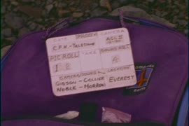
!["Lost Mine" - Lots Of Sparkle? - [camera rolls] 1-3](/uploads/r/null/1/2/1228427/87f57fea-95b8-42f9-888b-5b77a1ba730b-MI-315_142.jpg)
"Lost Mine" - Lots Of Sparkle? - [camera rolls] 1-3
![Mountain Springtime [answer print]](/uploads/r/null/1/9/1956270/94c77115-67ec-41f5-911a-60a0227d8732-MI-553_142.jpg)
Mountain Springtime [answer print]

Mountain springtime

[Men working on C.P.R. railway line uphill from the Nose tunnel in Mt. Stephen, on the Big Hill east of Field, B.C.]

In the Red Deer River
![Tourism B.C. Marketplace Progam [Program] - Expo 86](/uploads/r/null/1/2/1229032/56b256bc-a220-4356-82b5-6d7dc583fa08-MI-535_142.jpg)
Tourism B.C. Marketplace Progam [Program] - Expo 86
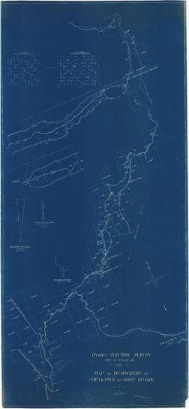
Map of headwaters of Cheakamus and Green rivers

General plan of works to be constructed at Nairn Falls. Green Lake. Lillooet District, B.C.

Plan showing road traverse and levels Agassiz to Harrison Lake

Plan of lands affected by the proposed power development from Bridge River, Lillooet District, BC

Garibaldi Lake, Daisy Lake and Cheakamus River

Junction of Cheakamus and Squamish Rivers and Cheakamus Canyon
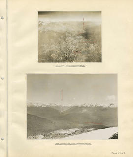
Region around Daisy Lake and Rubble Creek region
Aerial view - Lower Cheakamus Region and View looking east across Cheakamus Valley

Head of Callaghan Creek and Lower Callaghan Lake
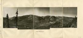
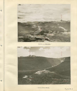
Panorama - Green River Valley from Green lake toward Pemberton Valley
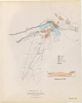
Topography of proposed dam site

Cheakamus River with proposed dam site at McGuire

Cheakamus River valley with possible dam location

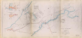
Topographical map of parts of the Cheakamus and Green River Valleys

Cheakamus power survey for City of Vancouver 1930-1931. Plan showing development from Garibaldi Lake to Daisy Lake

Cheakamus power survey for City of Vancouver 1930-1931. Plan showing topography southward along a line from Cheakamus River

Cheakamus power survey for City of Vancouver 1930-1931. Proposed storage reservoir at Daisy Lake
Cheakamus power survey for City of Vancouver 1930-1931. Plan showing proposed development for McGuire & Brandywine [Creek]

Cheakamus power survey for City of Vancouver 1930-1931. Plan showing proposed development at Cheakamus Lake

Cheakamus power survey for City of Vancouver 1930-1931. Mass curves showing Cheakamus River discharge

Cheakamus power survey for City of Vancouver 1930-1931. General plan and profile

Capilano River, Vancouver, B.C.

Mountain creek

Valley landscape

The gift of water

Majesty of water
![Lost Mine - 2 rolls orig[inal] neg[ative] - Shot [in] early 1970s Slumach - Lost Mine - rolls 3 [...](/uploads/r/null/1/2/1228538/ef869a1f-288a-476f-87a8-d77f30ffd7b8-MI-304_142.jpg)
Lost Mine - 2 rolls orig[inal] neg[ative] - Shot [in] early 1970s Slumach - Lost Mine - rolls 3 [and] 4
![Lost Mine - Cam[era rolls] - 15-17 [and] 17A](/uploads/r/null/1/2/1228411/bffeb635-4469-4dd7-ae83-03f9271a2c7a-MI-313_142.jpg)
Lost Mine - Cam[era rolls] - 15-17 [and] 17A

"Lost Mine" - 1 Roll 16mm Col Neg - 1-4