
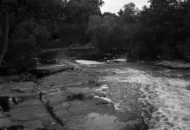
1 Napanee River
![2 - Mike Collier - San Francisco trip - 1971 - original ECO [Eastman Colour Original]](/uploads/r/null/1/9/1957050/11653000-54f5-4900-af14-0e08d984993b-MI-588_142.jpg)
2 - Mike Collier - San Francisco trip - 1971 - original ECO [Eastman Colour Original]
3 Napanee River

3117. Lower Kicking Horse Canyon near Golden, B.C.

3119. Twin Peaks and Boats, Bow River, Banff
![[A bridge over a river]](/uploads/r/null/e/9/c/e9c368f79303aeac8dad2c966d9421e077a127ef6c66c0b2a57e725def27ea6c/2637a56c-3392-4c2f-9024-a3f1a88844fd-CVA260-1991_142.jpg)
[A bridge over a river]
![[A dam across a river]](/uploads/r/null/3/9/1/391879463139bc6b45335bd04000254f9ef028d6f563ef99e75b29d0e4f7876e/d70b7f2b-dcd3-4ff3-84fa-457b77d1f84c-CVA260-2056_142.jpg)
[A dam across a river]

A fully loaded scow heading for the Klondike
![A glimpse at the Fraser above North Bend [B.C.]](/uploads/r/null/d/5/d58eedd0d62464aa6570d3e7e571039fbf7160ce94d474cc616ff5aae6d2f9f2/e37fee6b-bb59-4b09-b001-22bddd4c1f88-A04099_142.jpg)
A glimpse at the Fraser above North Bend [B.C.]
A mountain stream - Grouse Mountain
![[A river in a canyon]](/uploads/r/null/d/a/da21fe715a207f26ba06803c0d424a34b17c8688f211c549a063643daa91eff8/093e1ea4-25d2-43f4-8178-e1f624ca1f93-A20192_142.jpg)
[A river in a canyon]
![[A river in Quebec]](/uploads/r/null/9/8/98a43333f83521e578ed7803779a6775142de9dc98202f805971a10dd26951e4/f27c5b5f-e381-4114-bfed-d5e1db1d9c5b-A33162_142.jpg)
[A river in Quebec]

A river near Kandy, Ceylon
![[A river through a canyon]](/uploads/r/null/d/9/5/d959139d59cdd05d962c8fa77f12e5d44528c893fa4d437821b0bf194c5a717c/398641af-429f-4c71-8e17-e9230db9b31c-CVA260-1108_142.jpg)
[A river through a canyon]
![[A river through a canyon]](/uploads/r/null/c/2/e/c2e26af22d0e0a6923c4269e250ffe70e3c9a22d084543b9928c23e3284cd5dd/557afb71-e5f4-4ba9-85b3-839147d2ae7c-CVA260-1114_142.jpg)
[A river through a canyon]
![[A river through a valley]](/uploads/r/null/e/3/0/e30d3f8df8729c47ed489cdd352a76613bd2aa0392a18aab68a46702fce4762f/82accd1b-7983-4221-aab2-10d04bc82ea6-CVA260-1109_142.jpg)
[A river through a valley]
![[A river through a valley]](/uploads/r/null/4/b/6/4b638a68c508fd79a2b3afd0fe35be3f8c50c682551fa7ec9fabef70c4d791c9/7779ee05-7048-43fc-b506-a1762f0848d3-CVA260-1110_142.jpg)
[A river through a valley]
![[A river through a valley]](/uploads/r/null/9/d/3/9d3fdec451649574fa7ed0df2b0ce81002418f31bf2d703d58c005a07dd5c4da/95e24fd3-5c2a-42fa-bcdc-bf55eeaeea46-CVA260-1109_142.jpg)
[A river through a valley]
![[A river through a valley]](/uploads/r/null/8/1/e/81e0e6d35955c800656e02873f05c78caa14604ae6388bb6df9ce69c4319463e/62590fb7-22e8-464f-8f66-8fcd5624318b-CVA260-1109_142.jpg)
[A river through a valley]
![[A river through a valley]](/uploads/r/null/0/4/3/043818f7463b681d9c73a7e0996b01702ecec34de3301de26b26bfa761d2fe01/adde58ef-cd44-4588-8484-e1ece391c9f9-CVA260-1110_142.jpg)
[A river through a valley]
![[A river through a valley]](/uploads/r/null/e/a/4/ea477f6b1484c472747cdbd2a86adce495d3f5b980bfe860dfd9e5371c155c50/72e6da0d-aacc-4426-9bb3-f116d6fe972d-CVA260-1109_142.jpg)
[A river through a valley]
![[A river through a valley]](/uploads/r/null/c/3/2/c3282429356404b1c7f7889b4b9f06b9f447e3219712c767b63496b7854de06b/8628e913-aaa3-4be7-bf43-df877679df42-CVA260-1110_142.jpg)
[A river through a valley]
![[A river through a valley]](/uploads/r/null/a/7/c/a7c39ede2ebeca9d4bc1c717237088ab28853da1ea0704d303f977840367afdb/b6fdea2d-9acb-4d3b-a8ff-4afd109087bc-CVA260-1110_142.jpg)
[A river through a valley]
![[A riverbank]](/uploads/r/null/b/2/4/b2464c9da9969fdc3ffda5407a674078f1afebf821dfb11370fa4a96f10aad4c/e347198e-33f2-430b-8947-e5dc5295ef95-CVA260-1108_142.jpg)
[A riverbank]
![[A stream]](/uploads/r/null/4/f/4/4f436843207e8ee385151035b0fbfb41d6eb88cdce31feaa819e1ac12d0048c6/6b2266a7-2ee9-4e57-bfb3-b8120c0a8419-CVA260-1131_142.jpg)
[A stream]
![[A stream in Garibaldi District]](/uploads/r/null/7/d/7d775eb7c7d606878edffc9d5313c2eb2910bdc54c8855fa69a4e072da593a13/93706c88-fabe-44e2-97ce-4962c38c8f3d-A50096_142.jpg)
[A stream in Garibaldi District]
![[A stream on the Sumas Prairie]](/uploads/r/null/e/f/ef7d8cf52020b1e70a884d2cf9b6107128b6543ecc5f83d74aad50118e3267b5/804fe28d-ad0d-44df-acc2-345791ea47c0-A63104_142.jpg)
[A stream on the Sumas Prairie]
![[A train along a river]](/uploads/r/null/c/b/5/cb5a93a643ac658b27704d959fec39c5a39a311a381dd9dc9b51148a60a2e44a/2c8bfdef-a3d7-43fe-8e0b-bcdce6a5de40-CVA260-2064_142.jpg)
[A train along a river]
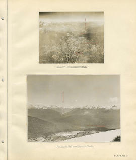
Aerial view - Lower Cheakamus Region and View looking east across Cheakamus Valley
![[Aerial view looking south of the] District of North Vancouver [between Seymour and Lynn Creeks]](/uploads/r/null/e/f/efec87eb86f83a0865fb63dd855e51942b3f5e6b75c5f105b15ef3db57d5b5c9/107091fb-3414-4f25-bc79-e59cee44fbab-A23496_142.jpg)
[Aerial view looking south of the] District of North Vancouver [between Seymour and Lynn Creeks]
![[Aerial view of Annacis Island and surrounding area during the Fraser River flood]](/uploads/r/null/8/6/86f336a392b2e63fe9ad7c407a94759fbba0440b22f898ac6f19d416451d16f4/07c70344-bc9e-42e2-81dc-f72a79dff600-A23475_142.jpg)
[Aerial view of Annacis Island and surrounding area during the Fraser River flood]
![[Aerial view of Fraser River flood and surrounding areas]](/uploads/r/null/b/a/ba7d2a125f6b034668f3b5db799085172d4b6176a0a15fd6640aa52f756097b8/101afdba-3c33-41d7-b770-62a007080dcb-A23477_142.jpg)
[Aerial view of Fraser River flood and surrounding areas]
![[Aerial view of Poplar Island, New Westminster, during the Fraser River flood]](/uploads/r/null/3/6/36467dd9e46f14d73fcc41b882f34e88c1f1e1fc4dcdeac47a02edc9c0c0e548/eeb199bd-5e48-4161-8c01-5977acd83cee-A23474_142.jpg)
[Aerial view of Poplar Island, New Westminster, during the Fraser River flood]
![[Aerial view of the Fraser River flood and surrounding areas]](/uploads/r/null/2/7/2749ceab3695f079945c8ceab77aa0cc238ba9056472d06ca9c52cd99d68e7a9/ff9c67ca-9723-40de-8d61-71df0fb7a708-A23476_142.jpg)
[Aerial view of the Fraser River flood and surrounding areas]
![[Aerial view of Vancouver International Airport looking south]](/uploads/r/null/4/e/7/4e733739b6b5b5fc2fc34b5e4e03032978086d6ed7b6d3291b6af05020ed4f5d/57dbc7d8-a33c-4f92-98a4-6c9e4d042748-CVA371-2950_142.jpg)
[Aerial view of Vancouver International Airport looking south]
![[Aerial view of Vancouver International Airport looking west]](/uploads/r/null/2/7/2/27213688730c7806e46019e512fc12a9c922c9ce4add27fa8b129850ee59a139/40e2c21f-6448-49bd-8d62-0920de53f118-CVA371-2949_142.jpg)
[Aerial view of Vancouver International Airport looking west]
![[After the Seymour Creek washout]](/uploads/r/null/5/c/5ce78c48ad131c7ac77f99c88ca6d74943fcb9c95021fe4e766d555295510090/8c8d33e3-d01d-4117-a063-3d17357fbde4-A33575_142.jpg)
[After the Seymour Creek washout]
![[Agassiz-Rosedale Bridge]](/uploads/r/null/b/9/b9a0eb51c46b2d4d18d17731a36fa41612fd8d34f153433851eda3dd6d55e728/ab733b8f-00dc-42e4-bf26-7ef4383180bb-A24439_142.jpg)
[Agassiz-Rosedale Bridge]
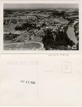
Air view - Ferndale, Washington

[Al Williamson carrying Percy Richards across a stream on Hollyburn Ridge during a visit to review a timber conservation plain]

"Albert Canyon". C.P.R. Selkirk Mountains

Albert Canyon from below, C.P.R. Selkirk
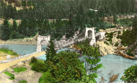
Alexandra Bridge over the Fraser River at Spuzzum, B.C.
Allscreen - Vancouver - reel #4
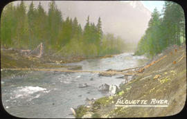
![Alouet [Alouette] River](/uploads/r/null/5/1/d/51de637e1a4a2ca13100cfa794f473602dbc32768e3d3e61ef3cd285e19c3e1e/464b66eb-b665-499f-a123-311af67a30c5-CVA289-002_142.jpg)
Alouet [Alouette] River
![Alouet [Alouette] River](/uploads/r/null/7/1/6/716744cfd76cf513da4c8c9d917feeb44b6d23de7a91241c603c5b1e9947e619/2eaa907b-05a3-4b67-b572-a1c468e1623e-CVA289-002_142.jpg)
Alouet [Alouette] River
![Alouet [Alouette] River](/uploads/r/null/3/3/7/337937ffadddd7589c4ed47dc69009852fdfc2f006e0b89c6170f7de4455906b/1809312a-48d9-42b5-88dd-7e946c8306f3-CVA289-002_142.jpg)
Alouet [Alouette] River
Alouette River
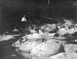
An English Stream

Ancient and present valleys of the Lynn River