![Rockies by Rail ; music and FX [effects] only offline](/uploads/r/null/1/2/1226802/a07ef359-4895-4843-9887-e5530191d8f3-MI-509_142.jpg)
Rockies by Rail ; music and FX [effects] only offline

Landscape - general : Fraser River

Geographical : Fraser River, dry interior
![[View of the Marpole rail and highway bridges]](/uploads/r/null/3/9/39d081635b9fd32192951910755276ab7921e8ca55e3206da51189c0b65a8080/015c04a5-11d7-4d15-95ab-e794ef8e9f32-A24442_142.jpg)
[View of the Marpole rail and highway bridges]
![[View of the Oak Street, B.C. Electric and Middle Arm bridges]](/uploads/r/null/8/d/8d4f4dea792a3128229aecfd55a12d3a3432476462ad8cd9991e1ebb16cae075/62c52137-d9af-48bd-a8bc-2a12293b382d-A24441_142.jpg)
[View of the Oak Street, B.C. Electric and Middle Arm bridges]
![[View of Oak Street, Marpole rail and highway and Middle Arm bridges]](/uploads/r/null/4/1/4199f99a2a9078cbea68581cb0c930996461009cc1719feede4e449ea5a2379d/94cbe073-4e30-45d0-baea-1b0cb58d69b4-A24443_142.jpg)
[View of Oak Street, Marpole rail and highway and Middle Arm bridges]
![[Northern view of Oak Street bridge under construction]](/uploads/r/null/3/c/3ce95649becd6661bfb266e929ef9f7f0fb0047a4e0c644d3975486d3b9ddc9c/cf895488-0c64-458d-913c-9deac49a536c-A24440_142.jpg)
[Northern view of Oak Street bridge under construction]
![[Agassiz-Rosedale Bridge]](/uploads/r/null/b/9/b9a0eb51c46b2d4d18d17731a36fa41612fd8d34f153433851eda3dd6d55e728/ab733b8f-00dc-42e4-bf26-7ef4383180bb-A24439_142.jpg)
[Agassiz-Rosedale Bridge]
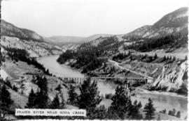
Fraser River Near Soda Creek
![[View of Hell's Gate]](/uploads/r/null/2/f/2fdf4fa5f2dd7e7537a8b7942a8f36ef4df55aa37ee3e9b7e4e0e9ba1b2c2b04/47b402d5-cfe3-453c-97f5-e5d8ceeb72f1-A33642_142.jpg)
[View of Hell's Gate]
![[Aerial view of Annacis Island and surrounding area during the Fraser River flood]](/uploads/r/null/8/6/86f336a392b2e63fe9ad7c407a94759fbba0440b22f898ac6f19d416451d16f4/07c70344-bc9e-42e2-81dc-f72a79dff600-A23475_142.jpg)
[Aerial view of Annacis Island and surrounding area during the Fraser River flood]
![[Aerial view of Fraser River flood and surrounding areas]](/uploads/r/null/b/a/ba7d2a125f6b034668f3b5db799085172d4b6176a0a15fd6640aa52f756097b8/101afdba-3c33-41d7-b770-62a007080dcb-A23477_142.jpg)
[Aerial view of Fraser River flood and surrounding areas]
![[Aerial view of Poplar Island, New Westminster, during the Fraser River flood]](/uploads/r/null/3/6/36467dd9e46f14d73fcc41b882f34e88c1f1e1fc4dcdeac47a02edc9c0c0e548/eeb199bd-5e48-4161-8c01-5977acd83cee-A23474_142.jpg)
[Aerial view of Poplar Island, New Westminster, during the Fraser River flood]
![[Aerial view of the Fraser River flood and surrounding areas]](/uploads/r/null/2/7/2749ceab3695f079945c8ceab77aa0cc238ba9056472d06ca9c52cd99d68e7a9/ff9c67ca-9723-40de-8d61-71df0fb7a708-A23476_142.jpg)
[Aerial view of the Fraser River flood and surrounding areas]
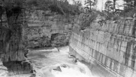
![[View of] Fraser Canyon [and River]](/uploads/r/null/2/8/28e9aec4f23f713eca8b4d1f8223ba4322de4b8b6b9b5c3f159df842b02b60cb/3b5d80a4-df70-44e9-a806-be893e3c0b12-A14541_142.jpg)
[View of] Fraser Canyon [and River]

Stream by Restmore Lodge
![Fraser River gorge below Pavilion [Plateau]](/uploads/r/null/4/8/2/482606067ff81312a229debcfa7087cfb6288650d13baf00d302ae45b6e318ef/86b23770-cbab-42aa-8e9d-763eddcdc952-CVA289-005_142.jpg)
Fraser River gorge below Pavilion [Plateau]
![[View of a powerhouse on the Illicillawaet River]](/uploads/r/null/7/0/706632d3b13dbcbc9e02110652a6e158c0fe0cea7d8195270edeaae2a74d330f/ab00bccd-229b-4018-8e11-356d3089e276-A26810_142.jpg)
[View of a powerhouse on the Illicillawaet River]

Bridge of Hope
![[Views of] Little Qualicum Falls, Vancouver Island](/uploads/r/null/c/3/c3bfd3ab42c5135d18ea82a298041d4c817cc59be2e43d6c9fceccbb3cfd9382/b093279c-d2bd-4407-b0f3-c13525069f21-A06926_142.jpg)
[Views of] Little Qualicum Falls, Vancouver Island
![The Fraser [below Pavilion Plateau]](/uploads/r/null/5/f/4/5f4ab903467499f7a433d631c81964b5e387a2eb92188d2d801fad1e03a285f1/f52d3b24-d90d-4f58-86e6-95dd44f736b0-CVA289-005_142.jpg)
The Fraser [below Pavilion Plateau]
![Bridge [over river near] Qualicum, Vancouver Island](/uploads/r/null/f/4/f471963def2007f032906a6ab7caa747c315bbeb6ed624f43e5ec3e0d8ca884b/1f140cf4-db3c-4174-84da-ed9111e8c370-A06925_142.jpg)
Bridge [over river near] Qualicum, Vancouver Island

Bridge and stream near Hope, B.C.
![[Ice on the Fraser River]](/uploads/r/null/8/5/85fc6b12abe76d00ad30113083ad972ee8d54c0435c053519a82a9101eedddc8/1297dbe3-4bf0-4e12-9ec8-14076e6b2967-A75602_142.jpg)
[Ice on the Fraser River]

Summer sun melts the 35 feet of snow and shows the last of our Western Ice Shield resting on a bed of cinders
![[Fraser River and Canyon]](/uploads/r/null/d/e/3/de367a6438c6fba400ae1752607b45e2276275473872b4fc32bde3cfb89b9a6d/52f17fec-2f80-4490-8f35-038fa3065892-CVA260-1839_142.jpg)
[Fraser River and Canyon]
![[Unidentified river]](/uploads/r/null/2/e/7/2e717f377f23cfef4de23ac8e46b7365f1e9d712ddf2098584e0d7235eec246b/061d620a-72f3-45fd-a505-fa0b89905588-CVA260-1841_142.jpg)
[Unidentified river]
![[Railway bridge over river]](/uploads/r/null/1/e/b/1eb795c087a0ff9f6c7ecb9241fdd993dc83ca2d097097bf62f5f6e3dd11cfc7/1bf242b7-0df4-4351-a328-e1f2235929f5-CVA260-1840_142.jpg)
[Railway bridge over river]

Nanaimo River, Vancouver Island

Vedder River
![[View from] P.G.E. [Railway of the] Fraser River Canyon](/uploads/r/null/5/a/5a4b4ea0f1a5c8248cebd14a9e76626bd64e612e69070364c48ce4588e64dbaa/968596ce-9e92-4866-a6d4-bb3faa2800e8-A76298_142.jpg)
[View from] P.G.E. [Railway of the] Fraser River Canyon
![Courtenay River [on] Vancouver Island](/uploads/r/null/a/1/a171b5097bf99be78bec10ac43b1c93417f5ca4cf635279950c632305a7f8187/22e3d9ac-9ebf-4305-8a70-bf4ffd1be553-A76338_142.jpg)
Courtenay River [on] Vancouver Island

Indian River

Cheakamus River

Coquitlam River near Essondale, B.C.

Indian River from the Palisades
Lunch place at Fannin Range

Squamish River
![[View of river bank and the mouth of the Indian River]](/uploads/r/null/5/7/57a6e8943fe56edf1c972fc1d8656c0d837ab9f77b754bad48b955356fa7a000/55e777d0-b314-49b5-96eb-b3ed75f83ca8-A63532_142.jpg)
[View of river bank and the mouth of the Indian River]

High up above the river
![Board of Trade trip, Okanagan and Kootenays : East Kootenay Power Co[mpany] Dam on Elk River](/uploads/r/null/1/d/6/1d6fc0ba1f763b7535ac5c09e812391579b339479eaea214a9892b6f81f001c6/1e07db6d-5672-405d-8371-b63e9e30db8a-CVA289-003_142.jpg)
Board of Trade trip, Okanagan and Kootenays : East Kootenay Power Co[mpany] Dam on Elk River
Board of Trade trip, Okanagan and Kootenays : The river at the power house

Board of Trade trip, Okanagan and Kootenays : The Penstock
![Elk River and Power house of East Kootenay Power Co[mpany]](/uploads/r/null/c/c/cc7d0fa99dc88c24c9cc772f60f4b9c89a7460174599372527fbae5f225bf00b/2afcde8f-2e93-4bc6-a36d-4ac8d6929107-A51022_142.jpg)
Elk River and Power house of East Kootenay Power Co[mpany]
Part of Canyon Elk River near Elko, part of old Dewdney Trail on left bank

Lower Canyon Elk River

Beavermouth River
![[Rushing water in the Fraser Canyon]](/uploads/r/null/2/1/21715087ddecd1c5815c41e3fc3ca0b834477e7e2d50933c7735d062ae653976/4531b6fb-f1b8-4597-910b-360aec8c8de5-A70993_142.jpg)
[Rushing water in the Fraser Canyon]
[Vancouver Board of Trade Excursion to Okanagan and Kootenays August 21 to September 5, 1926]
[Vancouver Board of Trade Excursion to Okanagan and Kootenays August 21 to September 5, 1926]
![Dam of East Kootenay Power Co[mpany] on Elk River](/uploads/r/null/a/0/a0f4906f3b29d9805f29da003b09b26771bac37a489afbb1c390dfe3630f09eb/c94425c7-f179-42e8-853f-a4601ffc3360-A51021_142.jpg)
Dam of East Kootenay Power Co[mpany] on Elk River