![Stoney Creek [and falls in the Selkirk Mountains]](/uploads/r/null/d/b/dbffd75c29847adc3f153a89d60134cc86fd2c190f11d1aa545d998997e70652/ac0abe89-4308-4e8a-867c-faffb2247c6e-A19750_142.jpg)
Stoney Creek [and falls in the Selkirk Mountains]
- AM54-S4-1-: CVA 4-33
- Item
- [ca. 1887]
Part of Major Matthews collection
108 results with digital objects Show results with digital objects
Stoney Creek [and falls in the Selkirk Mountains]
Part of Major Matthews collection
Part of Major Matthews collection
Part of Major Matthews collection

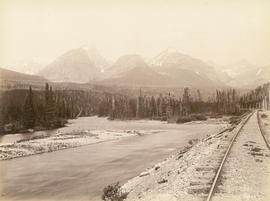
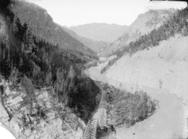
View toward Lytton from grade 2 miles below
Part of Major Matthews collection
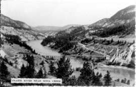
Photograph shows the Fraser River

View from rocks above Fraser Bridge
Part of Major Matthews collection
Photograph shows the Fraser River
Illecillewaet River and Sir Donald Peak, view at loop
Part of Major Matthews collection
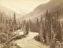
Photograph shows a log cabin under construction
![Devil's Gap [and] Beaver Canyon View No. 2](/uploads/r/null/4/4/44d0528e595370f28fc2340079698113fd07efcd4c94dca50739bca01fccf576/c7c99282-4843-4adf-822c-539477e63eb9-A19771_142.jpg)
Devil's Gap [and] Beaver Canyon View No. 2
Part of Major Matthews collection
Photograph shows 5 men standing beside the canyon. The canyon is located in the Selkirk mountain range.

Clearing rock slide at Hell's Gate, Fraser River
Part of Major Matthews collection

Clearing rock slide at Hell's Gate, Fraser River
Part of Major Matthews collection

Clearing rock slide at Hell's Gate, Fraser River
Part of Major Matthews collection

Clearing rock slide at Hell's Gate, Fraser River
Part of Major Matthews collection

Clearing rock slide at Hell's Gate, Fraser River
Part of Major Matthews collection

Clearing rock slide at Hell's Gate, Fraser River
Part of Major Matthews collection
![[View of a stream]](/uploads/r/null/1/7/174b6340e1b5afc241eeff8b60db572609019d8740fe546ebf3f5986ee949f65/8209c34b-adaa-481b-b1b3-8e610f2886af-A36256_142.jpg)
Part of Major Matthews collection
![[Unidentified river]](/uploads/r/null/7/c/7c465b50b08cfd44562abb76b326c4efd82b3a673e847a8c02767c311953734d/ef224504-23a8-4f79-8acd-6a3fb737a663-A19634_142.jpg)
Part of Major Matthews collection
![[Unidentified river]](/uploads/r/null/4/3/43c76914528b5028b8df887555e3b9ab5d9313175072c95841bbf9dee71ba782/fe0b94e1-31a0-45f6-9f8e-ed3002cc87dc-A19635_142.jpg)
Part of Major Matthews collection

The Kicking Horse River, C.P.R.
Part of Major Matthews collection

Hell's Gate, Fraser Canyon, B.C.
Part of Major Matthews collection
![[A stream on the Sumas Prairie]](/uploads/r/null/e/f/ef7d8cf52020b1e70a884d2cf9b6107128b6543ecc5f83d74aad50118e3267b5/804fe28d-ad0d-44df-acc2-345791ea47c0-A63104_142.jpg)
[A stream on the Sumas Prairie]
Part of Major Matthews collection
Part of Major Matthews collection

Part of Major Matthews collection
![[Rushing water in the Fraser Canyon]](/uploads/r/null/2/1/21715087ddecd1c5815c41e3fc3ca0b834477e7e2d50933c7735d062ae653976/4531b6fb-f1b8-4597-910b-360aec8c8de5-A70993_142.jpg)
[Rushing water in the Fraser Canyon]
Part of Major Matthews collection
Photograph shows ruins on the river bank
![[View of Harrison River near Harrison Hot Springs]](/uploads/r/null/9/4/94b928746a578d840c93a737853290befdee31bf36e4d7bba6a178fb2a7e02fa/b6ef2abc-d969-4772-a06a-00f038150bdd-A60333_142.jpg)
[View of Harrison River near Harrison Hot Springs]
Part of Major Matthews collection

Part of Major Matthews collection
Photograph shows the approach to Nairn Falls on Green River south of Pemberton
![[View of river bank and the mouth of the Indian River]](/uploads/r/null/5/7/57a6e8943fe56edf1c972fc1d8656c0d837ab9f77b754bad48b955356fa7a000/55e777d0-b314-49b5-96eb-b3ed75f83ca8-A63532_142.jpg)
[View of river bank and the mouth of the Indian River]
Part of Major Matthews collection
![[Aerial view of Poplar Island, New Westminster, during the Fraser River flood]](/uploads/r/null/3/6/36467dd9e46f14d73fcc41b882f34e88c1f1e1fc4dcdeac47a02edc9c0c0e548/eeb199bd-5e48-4161-8c01-5977acd83cee-A23474_142.jpg)
[Aerial view of Poplar Island, New Westminster, during the Fraser River flood]
Part of Major Matthews collection
![[Aerial view of Annacis Island and surrounding area during the Fraser River flood]](/uploads/r/null/8/6/86f336a392b2e63fe9ad7c407a94759fbba0440b22f898ac6f19d416451d16f4/07c70344-bc9e-42e2-81dc-f72a79dff600-A23475_142.jpg)
[Aerial view of Annacis Island and surrounding area during the Fraser River flood]
Part of Major Matthews collection
![[Aerial view of the Fraser River flood and surrounding areas]](/uploads/r/null/2/7/2749ceab3695f079945c8ceab77aa0cc238ba9056472d06ca9c52cd99d68e7a9/ff9c67ca-9723-40de-8d61-71df0fb7a708-A23476_142.jpg)
[Aerial view of the Fraser River flood and surrounding areas]
Part of Major Matthews collection
Photograph shows part of Lulu Island, Annacis Island, Robson Island and Poplar Island
![[Aerial view of Fraser River flood and surrounding areas]](/uploads/r/null/b/a/ba7d2a125f6b034668f3b5db799085172d4b6176a0a15fd6640aa52f756097b8/101afdba-3c33-41d7-b770-62a007080dcb-A23477_142.jpg)
[Aerial view of Fraser River flood and surrounding areas]
Part of Major Matthews collection
Photograph shows part of Lulu Island, Annacis Island, Robson Island and Poplar Island
Part of Major Matthews collection
![[Agassiz-Rosedale Bridge]](/uploads/r/null/b/9/b9a0eb51c46b2d4d18d17731a36fa41612fd8d34f153433851eda3dd6d55e728/ab733b8f-00dc-42e4-bf26-7ef4383180bb-A24439_142.jpg)
![[Northern view of Oak Street bridge under construction]](/uploads/r/null/3/c/3ce95649becd6661bfb266e929ef9f7f0fb0047a4e0c644d3975486d3b9ddc9c/cf895488-0c64-458d-913c-9deac49a536c-A24440_142.jpg)
[Northern view of Oak Street bridge under construction]
Part of Major Matthews collection
Oblique view shows the Marpole rail and highway bridges.
![[View of the Oak Street, B.C. Electric and Middle Arm bridges]](/uploads/r/null/8/d/8d4f4dea792a3128229aecfd55a12d3a3432476462ad8cd9991e1ebb16cae075/62c52137-d9af-48bd-a8bc-2a12293b382d-A24441_142.jpg)
[View of the Oak Street, B.C. Electric and Middle Arm bridges]
Part of Major Matthews collection
oblique view
![[View of the Marpole rail and highway bridges]](/uploads/r/null/3/9/39d081635b9fd32192951910755276ab7921e8ca55e3206da51189c0b65a8080/015c04a5-11d7-4d15-95ab-e794ef8e9f32-A24442_142.jpg)
[View of the Marpole rail and highway bridges]
Part of Major Matthews collection
Oblique view shows Vancouver International Airport.
![[View of Oak Street, Marpole rail and highway and Middle Arm bridges]](/uploads/r/null/4/1/4199f99a2a9078cbea68581cb0c930996461009cc1719feede4e449ea5a2379d/94cbe073-4e30-45d0-baea-1b0cb58d69b4-A24443_142.jpg)
[View of Oak Street, Marpole rail and highway and Middle Arm bridges]
Part of Major Matthews collection
Oblique view.

Part of Major Matthews collection
Photograph shows the Cariboo Road on the left
![Where the engine left the track 3 miles above Keefers [at Grasshopper trestle bridge]](/uploads/r/null/9/3/939dc62933962fdc80144e5e9ce01cc8cf0d38206027515a39d32bb66857530e/6f6faa78-1cee-42ad-b14e-609fca1657a3-A25454_142.jpg)
Where the engine left the track 3 miles above Keefers [at Grasshopper trestle bridge]
Part of Major Matthews collection

Part of Major Matthews collection

Part of Major Matthews collection

Part of Major Matthews collection

Fraser River, 4 miles below Lytton
Part of Major Matthews collection

Catching salmon, Fraser River, B.C.
Part of Major Matthews collection
Photograph shows various types of boats out on the river.
![[Man standing on log laid across Beaver Canyon]](/uploads/r/null/4/a/4a168c66111fa046a2da1cf47218694ca0cf8405a182eff3e653a9b0a6d82d05/9166132a-8a57-44b3-8f52-3b23b4d89d4a-A07948_142.jpg)
[Man standing on log laid across Beaver Canyon]
Part of Major Matthews collection
J.S. Matthews' notes with print or negative in Archives.

Part of Major Matthews collection
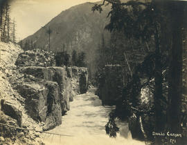
Photograph shows railway track running alongside river through mountains.
Bird's eye view Lower Kicking Horse Canyon
Part of Major Matthews collection
Photograph shws bridge, railway tracks and river through canyon.

Part of Major Matthews collection
Photograph shows area known as the Big Slide, Kicking Horse River, the slopes of Mt. Field (on right) and Mt. Burgess in the background.

Part of Major Matthews collection
![[Stoney creek above bridge]](/uploads/r/null/6/5/65968894e2350b386306c05daee296233c6239c4f3c9c316bc4862098f956987/8af3b7b9-a6ee-4646-9c71-d565d1c9f15f-A07969_142.jpg)
Part of Major Matthews collection
J.S. Matthews' notes with print or negative in Archives.

Stoney Creek Bridge 296 ft. high, highest wooden bridge in the world, Selkirks, C.P.R.
Part of Major Matthews collection
J.S. Matthews' notes with print or negative in Archives.

"Albert Canyon". C.P.R. Selkirk Mountains
Part of Major Matthews collection