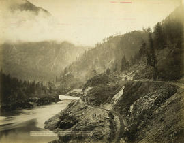
![[View of the Thompson River east of Lytton]](/uploads/r/null/b/5/b57bdc9554f4c089b187d1c5f5b233acbf931272e64dad2a0b54dd28040149cf/21978601-2e31-4d42-983f-3d601c619e55-A33843_142.jpg)
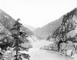
[View of the Thompson River east of Lytton]
- AM54-S4-: Out P932
- Item
- 1863 ; reproduced 1958
Part of Major Matthews collection
[View of the Thompson River east of Lytton]
Part of Major Matthews collection

Nicaragua Bluff and wagon road from west side of Fraser River
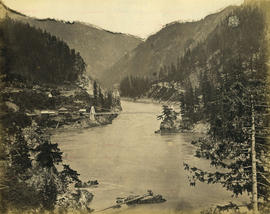
![Thompson River from Nicomen [Mountain] looking down 67 miles above Yale](/uploads/r/null/b/4/b4a259f5128b861d7e65e59d707e7e332111f4e3b39837b523d2d908d9362f5f/49bab35b-e81d-46d9-865e-3fc0376674ba-A19696_142.jpg)
Thompson River from Nicomen [Mountain] looking down 67 miles above Yale
![Wagon Road looking down [Fraser River]](/uploads/r/null/d/3/d31f33f3f68e921c25dc34269c92a6bbaa05550c337ff84c66b4e5640adc5d0d/6dbaba4f-967d-4271-857e-3299e25f0212-A19680_142.jpg)
Wagon Road looking down [Fraser River]
![Lady Franklin Rock [in the Fraser River near Yale]](/uploads/r/null/3/0/30e4a67b983698de8acc03740dd17a80e4f7a567b29da2ea51be9ea5c379c930/ee5161f4-0613-4294-9296-359f4eb8958f-A19670_142.jpg)
Lady Franklin Rock [in the Fraser River near Yale]
Photograph shows a view from the top of the Fraser Canyon
![Hell's Gate 17 miles above Yale [showing] entrance to Black Canyon](/uploads/r/null/2/7/27c3d0ea7cc412aa5a1d3ee403fda4079147cc4f843c4aa8cb2e8ce431e2e320/b6b5ff03-7f92-4b36-b0df-889321feb06d-A19686_142.jpg)
Hell's Gate 17 miles above Yale [showing] entrance to Black Canyon
Photograph shows fish-drying racks on the rocks beside the river
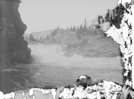
Lower Kananaskis Falls, C.P.R.
Part of Major Matthews collection

Part of Major Matthews collection

Fraser River, 4 miles below Lytton
Part of Major Matthews collection

Part of Major Matthews collection
Photograph shows the Cariboo Road on the left

View from rocks above Fraser Bridge
Part of Major Matthews collection
Photograph shows the Fraser River

Part of Major Matthews collection

View toward Lytton from grade 2 miles below
Part of Major Matthews collection
Photograph shows the Fraser River

Part of Major Matthews collection
![Where the engine left the track 3 miles above Keefers [at Grasshopper trestle bridge]](/uploads/r/null/9/3/939dc62933962fdc80144e5e9ce01cc8cf0d38206027515a39d32bb66857530e/6f6faa78-1cee-42ad-b14e-609fca1657a3-A25454_142.jpg)
Where the engine left the track 3 miles above Keefers [at Grasshopper trestle bridge]
Part of Major Matthews collection

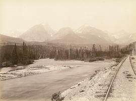
View four miles east of Revelstoke
Part of Major Matthews collection
Part of Major Matthews collection

Second C.P.R. crossing of Illecillewaet
Part of Major Matthews collection
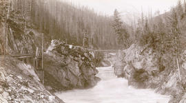
![Devil's Gap [and] Beaver Canyon View No. 2](/uploads/r/null/4/4/44d0528e595370f28fc2340079698113fd07efcd4c94dca50739bca01fccf576/c7c99282-4843-4adf-822c-539477e63eb9-A19771_142.jpg)
Devil's Gap [and] Beaver Canyon View No. 2
Part of Major Matthews collection
Photograph shows 5 men standing beside the canyon. The canyon is located in the Selkirk mountain range.
Part of Major Matthews collection
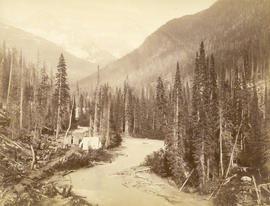
Illecillewaet River and Sir Donald Peak, view at loop
Part of Major Matthews collection
Photograph shows a log cabin under construction
![Stoney Creek [and falls in the Selkirk Mountains]](/uploads/r/null/d/b/dbffd75c29847adc3f153a89d60134cc86fd2c190f11d1aa545d998997e70652/ac0abe89-4308-4e8a-867c-faffb2247c6e-A19750_142.jpg)
Stoney Creek [and falls in the Selkirk Mountains]
Part of Major Matthews collection
Bluffs, 2 1/2 miles above Yale looking down valley
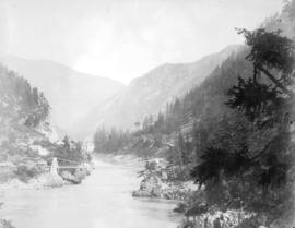
![[View of the Fraser River and Hope Mountain]](/uploads/r/null/2/b/2b2b39eaeb5e45208b13e02bd5e8574cea233047ebebbe08b8e85d258da6a469/a09129e9-56fe-44c1-9b3d-dd9af1ef3612-A31717_142.jpg)
[View of the Fraser River and Hope Mountain]
Part of Major Matthews collection
Suspension bridge from railroad side of river looking up
Photograph shows the Alexandra Bridge

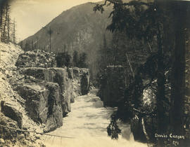
Black Canyon and railway grade looking down valley from 17th mile post on wagon road

Tunnel No. 1 and Yale looking down valley

Tunnels, 11, 12 and 13 looking up river from top of Tunnel No. 10 - 10 3/4 miles above Yale

Surprise Creek Bridge C.P.R. Selkirks Height 157 feet
![[Hell's Gate on the Fraser River]](/uploads/r/null/7/d/7d9c426ae0e04278d0dddc1daae0c8a3ca38b75cc25820e9fb31cd1ad2aecb7e/43520846-2927-47f0-94f8-a72ede6f306b-A33713_142.jpg)
[Hell's Gate on the Fraser River]
Part of Major Matthews collection

Albert Canyon from below, C.P.R. Selkirk
Part of Major Matthews collection

Part of Major Matthews collection

Looking Up the Fraser near Yale, B.C.
![[View of a canyon from a C.P.R. train]](/uploads/r/null/e/9/e949ed24fbba41ac9599b565d20e487e2fb05725e1138ade99a6b4f85a477dae/4cd01f99-3e8c-47f2-a83b-c4d15060cd4b-A33117_142.jpg)
[View of a canyon from a C.P.R. train]
Part of Major Matthews collection
![Hill's [Hell's] Gate Canyon, Fraser River](/uploads/r/null/d/0/d0e6e3a420fd20caa4c5d023bc3fa58db42a28c91b47090d5bc692a302f3dff5/f2b7d4b5-29a7-47f4-a0ff-d833542506c9-A26799_142.jpg)
Hill's [Hell's] Gate Canyon, Fraser River
Part of Major Matthews collection
Part of Major Matthews collection

![Hill's [Hell's] Gate Canyon, Fraser River](/uploads/r/null/c/7/c7f92cbe21a70263cb4b6d5c0c157d12a94237293781fef80d8e2dd972fd1563/10a1c8ab-a1e9-4173-8670-a429a0afc682-A71369_142.jpg)
Hill's [Hell's] Gate Canyon, Fraser River

Stoney Creek Bridge C.P.R. Selkirks Height 296 feet from below
![Looking up river from Bridge [towards] Eburne](/uploads/r/null/a/5/a53a6dfecbc6757f87c7d28f52640dacac5bc041671f19ec13ffa8304d92e103/8f4a1d66-c230-4858-9b57-9509eef6e45f-A26852_142.jpg)
Looking up river from Bridge [towards] Eburne
Part of Major Matthews collection
![[Pipes and planks scattered in creek bed in mountains]](/uploads/r/null/7/e/7e764d6a02cf3e8d0076fc84d4087ce147751a89ff4dcf266f47f3b87a419e64/83449602-6ae0-4a00-b2a9-5bb5a5e322e3-A04198_142.jpg)
[Pipes and planks scattered in creek bed in mountains]
Part of Major Matthews collection
J.S. Matthews' notes with print or negative in Archives.
Suspension Bridge near Spuzzum
Part of Major Matthews collection
![On the Fraser [River] near Spuzzum](/uploads/r/null/3/2/32f8b38783fcb7690bdda11d48d96df873f48332f3e55215a3b6ae7a916f5e5c/3aebe5ff-fe49-4a8d-a990-82e6ae992ca0-A33058_142.jpg)
On the Fraser [River] near Spuzzum
Part of Major Matthews collection
Hell's Gate Canyon on the Fraser near North Bend
Part of Major Matthews collection
Photograph shows a salmon drying rack in the foreground

Fraser Canyon, Yale in Distance
Part of Major Matthews collection
![[Two river steamers near shore on Fraser River]](/uploads/r/null/d/4/d41057d04545659ef5332b2fe4c1ce0f7a04e6f3623b978383ad4fbacc12f6ea/70274328-1fc5-4748-b51c-0b7ecbc67d27-A04274_142.jpg)
[Two river steamers near shore on Fraser River]
Part of Major Matthews collection
J.S. Matthews' notes with print or negative in Archives.

Suspension Bridge near Spuzzum

Sir Donald Peak and Great Glacier, Selkirks
Part of Major Matthews collection
![[View of the C.P.R. Salmon River (Nahatlat) Bridge]](/uploads/r/null/0/9/097a0f7bb11951a512d36f2776cccf3f322ae5d5463104dfedbef9b6a2d8a333/50b2ea02-5c7b-4a3d-9ae4-f4b97debb757-A26914_142.jpg)
[View of the C.P.R. Salmon River (Nahatlat) Bridge]
Part of Major Matthews collection

"China Bluff", Fraser Canyon, B.C.
Part of Major Matthews collection