
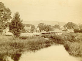
The Lions and Capilano River, Vancouver, B.C. Canada
- AM1052-: AM1052 P-855-: AM1052 P-855.03
- Part
- [192-?]
Item is a postcard
990 results with digital objects Show results with digital objects
The Lions and Capilano River, Vancouver, B.C. Canada
Item is a postcard
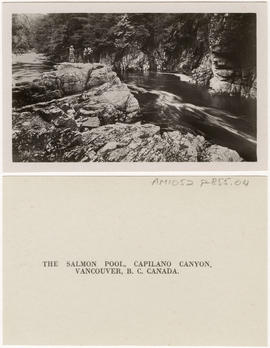
The Salmon Pool, Capilano Canyon, Vancouver, B.C., Canada
Item is a postcard
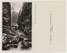
In Capilano Canyon, Vancouver, B.C. Canada
Item is a postcard
![Suspension Bridge, Capilano Canyon, Height 200 ft,, Lentgh [Length] 450 ft, Vancouver, B.C. Canada](/uploads/r/null/5/5/a/55a2c61dc1b86111d8c33c8242c4f1d14cc6a09c4db9ef1e7b0664fbeb991b45/ae7ddc36-6a5f-42f2-9c06-b7a0bfc3fab9-AM1052P-855_142.jpg)
Suspension Bridge, Capilano Canyon, Height 200 ft,, Lentgh [Length] 450 ft, Vancouver, B.C. Canada
Item is a postcard
![[View of the Thompson River east of Lytton]](/uploads/r/null/b/5/b57bdc9554f4c089b187d1c5f5b233acbf931272e64dad2a0b54dd28040149cf/21978601-2e31-4d42-983f-3d601c619e55-A33843_142.jpg)
[View of the Thompson River east of Lytton]
Part of Major Matthews collection
![[Waterfront view of Yale - Frazer [Fraser] River](/uploads/r/null/c/b/cb93dac894f555448d19c45ef7ca3ab754bd1169c311d9479183cb3bc3b1ce24/1c23e657-aa7a-49ac-8784-e7f1a94285cb-A22912_142.jpg)
[Waterfront view of Yale - Frazer [Fraser] River
Part of Major Matthews collection
![Steamer "Onward" [on the] Frazer [Fraser] River](/uploads/r/null/1/2/12c7dd8314d79146e8c106ae2679b56ba1b1665eb9995779eddd510e52285a10/b4acb919-102e-44aa-9137-ce83364f3618-A22910_142.jpg)
Steamer "Onward" [on the] Frazer [Fraser] River
Part of Major Matthews collection

Nicaragua Bluff and wagon road from west side of Fraser River
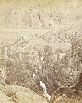
![Thompson River from Nicomen [Mountain] looking down 67 miles above Yale](/uploads/r/null/b/4/b4a259f5128b861d7e65e59d707e7e332111f4e3b39837b523d2d908d9362f5f/49bab35b-e81d-46d9-865e-3fc0376674ba-A19696_142.jpg)
Thompson River from Nicomen [Mountain] looking down 67 miles above Yale
![Wagon Road looking down [Fraser River]](/uploads/r/null/d/3/d31f33f3f68e921c25dc34269c92a6bbaa05550c337ff84c66b4e5640adc5d0d/6dbaba4f-967d-4271-857e-3299e25f0212-A19680_142.jpg)
Wagon Road looking down [Fraser River]
![Lady Franklin Rock [in the Fraser River near Yale]](/uploads/r/null/3/0/30e4a67b983698de8acc03740dd17a80e4f7a567b29da2ea51be9ea5c379c930/ee5161f4-0613-4294-9296-359f4eb8958f-A19670_142.jpg)
Lady Franklin Rock [in the Fraser River near Yale]
Photograph shows a view from the top of the Fraser Canyon
Nicomen looking down the creek to the Thompson River - 67 miles above Yale
![Yale [showing] gold field opposite [across Fraser River]](/uploads/r/null/c/3/c3b5a65995f782ba54ae03df2bc55bc472f06f2cd8d25cf526390df9e47e33c8/de7cdbe7-5ba9-447a-a911-7c4a52876faf-A19666_142.jpg)
Yale [showing] gold field opposite [across Fraser River]
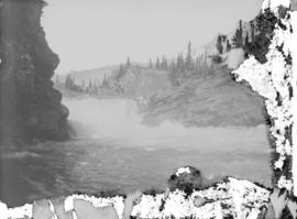
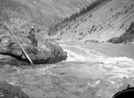
![Hell's Gate 17 miles above Yale [showing] entrance to Black Canyon](/uploads/r/null/2/7/27c3d0ea7cc412aa5a1d3ee403fda4079147cc4f843c4aa8cb2e8ce431e2e320/b6b5ff03-7f92-4b36-b0df-889321feb06d-A19686_142.jpg)
Hell's Gate 17 miles above Yale [showing] entrance to Black Canyon
Photograph shows fish-drying racks on the rocks beside the river

Lower Kananaskis Falls, C.P.R.
Part of Major Matthews collection
Part of Major Matthews collection

Part of Major Matthews collection
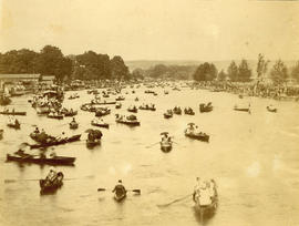
The Regatta - Henley-On-Thames
Part of Major Matthews collection

Part of Major Matthews collection
Photograph shows Temple Island in the background

Henley Regatta - Eton and Leander Race
Part of Major Matthews collection

Sub-contractor's Camp, near Fraser River Crossing
Part of Major Matthews collection

Part of Major Matthews collection

Fraser River, 4 miles below Lytton
Part of Major Matthews collection

Fraser River above Cantilever Bridge
Part of Major Matthews collection
Photograph shows the Cariboo road on the left

Part of Major Matthews collection
Photograph shows the Cariboo Road on the left

Part of Major Matthews collection

View from rocks above Fraser Bridge
Part of Major Matthews collection
Photograph shows the Fraser River

Part of Major Matthews collection
![Where the engine left the track 3 miles above Keefers [at Grasshopper trestle bridge]](/uploads/r/null/9/3/939dc62933962fdc80144e5e9ce01cc8cf0d38206027515a39d32bb66857530e/6f6faa78-1cee-42ad-b14e-609fca1657a3-A25454_142.jpg)
Where the engine left the track 3 miles above Keefers [at Grasshopper trestle bridge]
Part of Major Matthews collection

Part of Major Matthews collection

View toward Lytton from grade 2 miles below
Part of Major Matthews collection
Photograph shows the Fraser River

View four miles east of Revelstoke
Part of Major Matthews collection
Part of A.W. Phair fonds

Second C.P.R. crossing of Illecillewaet
Part of Major Matthews collection
Part of Major Matthews collection
![Devil's Gap [and] Beaver Canyon View No. 2](/uploads/r/null/4/4/44d0528e595370f28fc2340079698113fd07efcd4c94dca50739bca01fccf576/c7c99282-4843-4adf-822c-539477e63eb9-A19771_142.jpg)
Devil's Gap [and] Beaver Canyon View No. 2
Part of Major Matthews collection
Photograph shows 5 men standing beside the canyon. The canyon is located in the Selkirk mountain range.
![[The Howe truss bridge]](/uploads/r/null/4/c/4c4775923ef2f5c6691e5190b954de97096b0f4569d121a31624b5a281a341d7/f4964437-02ca-429b-a8ea-db523d77a0f5-A33606_142.jpg)
Part of Major Matthews collection
Photograph shows Mount Chadwick on the left

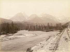
Bow River and mountains west of Banff
Part of Major Matthews collection
Part of Major Matthews collection
Illecillewaet River and Sir Donald Peak, view at loop
Part of Major Matthews collection
Photograph shows a log cabin under construction
![Stoney Creek [and falls in the Selkirk Mountains]](/uploads/r/null/d/b/dbffd75c29847adc3f153a89d60134cc86fd2c190f11d1aa545d998997e70652/ac0abe89-4308-4e8a-867c-faffb2247c6e-A19750_142.jpg)
Stoney Creek [and falls in the Selkirk Mountains]
Part of Major Matthews collection
![[Lytton showing the Fraser and Thompson Rivers]](/uploads/r/null/3/6/363d9af3f46b0dc6bd0041847bf42ae6109d742361f42b0dc748b0f9bd343564/c34bcaf9-67fa-4bee-9112-b595cb68d575-A31726_142.jpg)
[Lytton showing the Fraser and Thompson Rivers]
Part of Major Matthews collection
![[View of the Fraser River and Hope Mountain]](/uploads/r/null/2/b/2b2b39eaeb5e45208b13e02bd5e8574cea233047ebebbe08b8e85d258da6a469/a09129e9-56fe-44c1-9b3d-dd9af1ef3612-A31717_142.jpg)
[View of the Fraser River and Hope Mountain]
Part of Major Matthews collection
![[Man spearing salmon in Seymour Creek]](/uploads/r/null/8/7/87148857ce94646d1531f9ee8957aad670b22e3eb8951b4d71247bc0c327733a/31213c49-ad70-4a56-af4f-c2a107c5c701-A04199_142.jpg)
[Man spearing salmon in Seymour Creek]
Part of Major Matthews collection
J.S. Matthews' notes with print or negative in Archives.
Bluffs, 2 1/2 miles above Yale looking down valley
Suspension bridge from railroad side of river looking up
Photograph shows the Alexandra Bridge
![[North Arm Bridge, Sea Island]](/uploads/r/null/1/0/10a582832d25f36f580ea5f85b55ab839bd9bd7cb282d7f4e8fc8e19e0d81e6f/6711c6a3-6a86-4e39-833c-1289327ec3f5-A04127_142.jpg)
[North Arm Bridge, Sea Island]
Part of Major Matthews collection
Photograph shows shoreline, river, and bridge.

Black Canyon and railway grade looking down valley from 17th mile post on wagon road

Tunnel No. 1 and Yale looking down valley