![[A bridge over a river]](/uploads/r/null/e/9/c/e9c368f79303aeac8dad2c966d9421e077a127ef6c66c0b2a57e725def27ea6c/2637a56c-3392-4c2f-9024-a3f1a88844fd-CVA260-1991_142.jpg)
[A bridge over a river]
![[A river in a canyon]](/uploads/r/null/d/a/da21fe715a207f26ba06803c0d424a34b17c8688f211c549a063643daa91eff8/093e1ea4-25d2-43f4-8178-e1f624ca1f93-A20192_142.jpg)
[A river in a canyon]
![[A river through a canyon]](/uploads/r/null/d/9/5/d959139d59cdd05d962c8fa77f12e5d44528c893fa4d437821b0bf194c5a717c/398641af-429f-4c71-8e17-e9230db9b31c-CVA260-1108_142.jpg)
[A river through a canyon]
![[A river through a canyon]](/uploads/r/null/c/2/e/c2e26af22d0e0a6923c4269e250ffe70e3c9a22d084543b9928c23e3284cd5dd/557afb71-e5f4-4ba9-85b3-839147d2ae7c-CVA260-1114_142.jpg)
[A river through a canyon]
![[A river through a valley]](/uploads/r/null/e/3/0/e30d3f8df8729c47ed489cdd352a76613bd2aa0392a18aab68a46702fce4762f/82accd1b-7983-4221-aab2-10d04bc82ea6-CVA260-1109_142.jpg)
[A river through a valley]
![[A river through a valley]](/uploads/r/null/4/b/6/4b638a68c508fd79a2b3afd0fe35be3f8c50c682551fa7ec9fabef70c4d791c9/7779ee05-7048-43fc-b506-a1762f0848d3-CVA260-1110_142.jpg)
[A river through a valley]
![[A river through a valley]](/uploads/r/null/9/d/3/9d3fdec451649574fa7ed0df2b0ce81002418f31bf2d703d58c005a07dd5c4da/95e24fd3-5c2a-42fa-bcdc-bf55eeaeea46-CVA260-1109_142.jpg)
[A river through a valley]
![[A river through a valley]](/uploads/r/null/8/1/e/81e0e6d35955c800656e02873f05c78caa14604ae6388bb6df9ce69c4319463e/62590fb7-22e8-464f-8f66-8fcd5624318b-CVA260-1109_142.jpg)
[A river through a valley]
![[A river through a valley]](/uploads/r/null/0/4/3/043818f7463b681d9c73a7e0996b01702ecec34de3301de26b26bfa761d2fe01/adde58ef-cd44-4588-8484-e1ece391c9f9-CVA260-1110_142.jpg)
[A river through a valley]
![[A river through a valley]](/uploads/r/null/e/a/4/ea477f6b1484c472747cdbd2a86adce495d3f5b980bfe860dfd9e5371c155c50/72e6da0d-aacc-4426-9bb3-f116d6fe972d-CVA260-1109_142.jpg)
[A river through a valley]
![[A river through a valley]](/uploads/r/null/c/3/2/c3282429356404b1c7f7889b4b9f06b9f447e3219712c767b63496b7854de06b/8628e913-aaa3-4be7-bf43-df877679df42-CVA260-1110_142.jpg)
[A river through a valley]
![[A river through a valley]](/uploads/r/null/a/7/c/a7c39ede2ebeca9d4bc1c717237088ab28853da1ea0704d303f977840367afdb/b6fdea2d-9acb-4d3b-a8ff-4afd109087bc-CVA260-1110_142.jpg)
[A river through a valley]
![[A riverbank]](/uploads/r/null/b/2/4/b2464c9da9969fdc3ffda5407a674078f1afebf821dfb11370fa4a96f10aad4c/e347198e-33f2-430b-8947-e5dc5295ef95-CVA260-1108_142.jpg)
[A riverbank]
![[A stream]](/uploads/r/null/4/f/4/4f436843207e8ee385151035b0fbfb41d6eb88cdce31feaa819e1ac12d0048c6/6b2266a7-2ee9-4e57-bfb3-b8120c0a8419-CVA260-1131_142.jpg)
[A stream]
![[A stream in Garibaldi District]](/uploads/r/null/7/d/7d775eb7c7d606878edffc9d5313c2eb2910bdc54c8855fa69a4e072da593a13/93706c88-fabe-44e2-97ce-4962c38c8f3d-A50096_142.jpg)
[A stream in Garibaldi District]
![[A stream on the Sumas Prairie]](/uploads/r/null/e/f/ef7d8cf52020b1e70a884d2cf9b6107128b6543ecc5f83d74aad50118e3267b5/804fe28d-ad0d-44df-acc2-345791ea47c0-A63104_142.jpg)
[A stream on the Sumas Prairie]
![[Aerial view of Annacis Island and surrounding area during the Fraser River flood]](/uploads/r/null/8/6/86f336a392b2e63fe9ad7c407a94759fbba0440b22f898ac6f19d416451d16f4/07c70344-bc9e-42e2-81dc-f72a79dff600-A23475_142.jpg)
[Aerial view of Annacis Island and surrounding area during the Fraser River flood]
![[Aerial view of Fraser River flood and surrounding areas]](/uploads/r/null/b/a/ba7d2a125f6b034668f3b5db799085172d4b6176a0a15fd6640aa52f756097b8/101afdba-3c33-41d7-b770-62a007080dcb-A23477_142.jpg)
[Aerial view of Fraser River flood and surrounding areas]
![[Aerial view of Poplar Island, New Westminster, during the Fraser River flood]](/uploads/r/null/3/6/36467dd9e46f14d73fcc41b882f34e88c1f1e1fc4dcdeac47a02edc9c0c0e548/eeb199bd-5e48-4161-8c01-5977acd83cee-A23474_142.jpg)
[Aerial view of Poplar Island, New Westminster, during the Fraser River flood]
![[Aerial view of the Fraser River flood and surrounding areas]](/uploads/r/null/2/7/2749ceab3695f079945c8ceab77aa0cc238ba9056472d06ca9c52cd99d68e7a9/ff9c67ca-9723-40de-8d61-71df0fb7a708-A23476_142.jpg)
[Aerial view of the Fraser River flood and surrounding areas]
![[Agassiz-Rosedale Bridge]](/uploads/r/null/b/9/b9a0eb51c46b2d4d18d17731a36fa41612fd8d34f153433851eda3dd6d55e728/ab733b8f-00dc-42e4-bf26-7ef4383180bb-A24439_142.jpg)
[Agassiz-Rosedale Bridge]

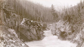
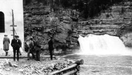
"Albert Canyon". C.P.R. Selkirk Mountains

Albert Canyon from below, C.P.R. Selkirk
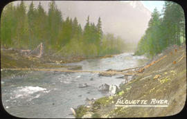
Alouette River

At the mouth of the Harrison River, B.C.
![[Baptist Church on a barge on the Fraser River]](/uploads/r/null/0/e/0e81c49380b3b53f9bb1c9494ea17562db62c851985e5b43084fe3ecd9c8e810/fbe57649-33a5-4979-a36d-fa5f5d1dd308-A50824_142.jpg)
[Baptist Church on a barge on the Fraser River]
![[Baptist Church on a barge on the Fraser River]](/uploads/r/null/4/e/4ee700c759f613711e86c603162e4dcb7803b50b8b999ae31893a018b968043f/e81782e5-3f72-46e6-b18f-0ff168ebe237-A50825_142.jpg)
[Baptist Church on a barge on the Fraser River]
Beaver Canyon Selkirks, B.C.

Beaver Canyon, B.C.

Beaver Canyon, B.C.

Beaver Canyon, B.C.

Beaver Canyon, Selkirks B.C.

Beavermouth River
Bird's eye view Lower Kicking Horse Canyon

Black Canyon and railway grade looking down valley from 17th mile post on wagon road
Bluffs, 2 1/2 miles above Yale looking down valley
Board of Trade - Fraser River, Cariboo
![Board of Trade trip, Okanagan and Kootenays : East Kootenay Power Co[mpany] Dam on Elk River](/uploads/r/null/1/d/6/1d6fc0ba1f763b7535ac5c09e812391579b339479eaea214a9892b6f81f001c6/1e07db6d-5672-405d-8371-b63e9e30db8a-CVA289-003_142.jpg)
Board of Trade trip, Okanagan and Kootenays : East Kootenay Power Co[mpany] Dam on Elk River

Board of Trade trip, Okanagan and Kootenays : The Penstock
Board of Trade trip, Okanagan and Kootenays : The river at the power house

Bridge and stream near Hope, B.C.

Bridge of Hope
![Bridge [over river near] Qualicum, Vancouver Island](/uploads/r/null/f/4/f471963def2007f032906a6ab7caa747c315bbeb6ed624f43e5ec3e0d8ca884b/1f140cf4-db3c-4174-84da-ed9111e8c370-A06925_142.jpg)
Bridge [over river near] Qualicum, Vancouver Island

Building stone wall. C.P.R.near Keefer's Station
![[Canadian Pacific rail line along the Fraser River]](/uploads/r/null/f/5/f5068a6b7c226036874b05895a1ce07e51790a03e2d69a53f27e91e33c04121d/ce9b2c39-5dcc-4d47-ada8-79bc292af478-A03866_142.jpg)
[Canadian Pacific rail line along the Fraser River]
![Canon [Canyon], Fraser River](/uploads/r/null/6/a/6abe69d2d0b2c3d79e4aaea6d4855420c2b12c7305709c597b3775c39e86ae6f/b4e77f13-e136-45a7-afe2-a1b9c59fe280-A26891_142.jpg)
Canon [Canyon], Fraser River
![[Capilano River]](/uploads/r/null/b/7/b7be2412e326a0c6f6201ef5cf910c7220fdd88f148b4db420c52812c2073ac7/aefd5b68-5e12-463d-b97c-3b4061d4c1bc-A20100_142.jpg)
[Capilano River]
![Carpenter Creek Canyon, K & S R[ailway] near Sandon, B.C.](/uploads/r/null/3/2/32e655bf8878e9a0b0efbc02da7c229fc00767617535fa38b2b5a5583fce1b1c/4691d47c-a571-42e1-aded-c4affb5e0010-A19466_142.jpg)
Carpenter Creek Canyon, K & S R[ailway] near Sandon, B.C.
![Castle Rock [on the] Fraser River](/uploads/r/null/2/4/c/24ce11c20d9284777153cf0fd69430f8262fe8349e8c15974ad42051753b501a/1dcb6f86-11dc-4487-8dfa-fc4adc1cbf60-CVA260-1964_142.jpg)
Castle Rock [on the] Fraser River

Catching salmon, Fraser River, B.C.