![[View of downtown Vancouver from Burrard Inlet]](/uploads/r/null/2/2/227f3e3d1efc46952bc6af839b20a2240795e45197b4979434792a196b0de198/3696f49f-093e-41b3-9aa6-3d0385dc0805-A37857_142.jpg)
[View of downtown Vancouver from Burrard Inlet]
- AM1376-: CVA 1376-130
- Item
- [between 1915 and 1925]
Photograph shows the downtown Vancouver skyline (including the new Hotel Vancouver) viewed from Burrard Inlet.
11 results with digital objects Show results with digital objects
[View of downtown Vancouver from Burrard Inlet]
Photograph shows the downtown Vancouver skyline (including the new Hotel Vancouver) viewed from Burrard Inlet.
![[View of] 555 Howe Street [after snow storm]](/uploads/r/null/4/2/429f9afdecfc8918791fb142cd48e010d86cbe39295b8ce9f089cc1a2fe58301/166dbacc-97e8-40d1-af8f-a5e626ea29ab-A59798_142.jpg)
[View of] 555 Howe Street [after snow storm]
Photographs shows buildings and businesses in the 500 block Howe Street.

Item shows Coal Harbour looking toward downtown.
Aerial photo, oblique, downtown Vancouver
Item is a photograph of downtown Vancouver looking northeast. The photo is centred on the Hotel Vancouver and includes the provincial courthouse, surrounding areas, and part of the port of Vancouver.

Aerial photo, oblique, False Creek, Vancouver
Item is a photograph of False Creek, looking northeast. The photo has (from left to right) the Burrard bridge, the Kitsilano Trestle Bridge, the (old) Granville Street Bridge, and the Cambie Bridge.

Aerial photo, oblique, downtown Vancouver to North Shore Mountains
Item is a photograph of the Vancouver area looking northwest over downtown Vancouver including the Hotel Vancouver, Provincial Courts, the Marine Building, Stanley Park, Burrard Inlet, Lion's Gate Bridge, and Coal Harbour.

Aerial photo, oblique, CPR docks in foreground, looking south Granville Street at centre
Item is a photograph of the Vancouver waterfront, looking southwest down Burrard Street, showing the waterfront and downtown Vancouver, including Waterfront Station, Hotel Vancouver, Marine Building, Burrard Bridge, Granville Street Bridge, and the city beyond.
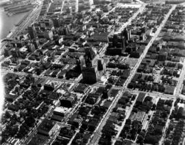
![[Aerial photograph of downtown Vancouver looking north]](/uploads/r/null/2/4/24032a0f19bc217e5bb533d7218824f932301e972f1020a352118b50afcf8a93/8e2450db-6794-4283-95a6-7641bc80437d-A69847_142.jpg)
[Aerial photograph of downtown Vancouver looking north]
Photograph shows an oblique view of the north shore of False Creek including the C.P.R. Roundhouse, Yaletown, Cambie Bridge (old), Sweeney Cooperage, Georgia Viaduct, Post Office building under construction, Pier "B/C", Coal Harbour, Stanley Park, Lions Gate Bridge and a view of North and West Vancouver.

Aerial photo, vertical, False Creek, Fairview to Kits Point
Item is a photograph of False Creek, showing English Bay to W 16th Avenue, and from Maple Street to the Cambie Street Bridge. Includes the Burrard Street Bridge, the new Granville Bridge, the Cambie Bridge, and Granville Island.
![[Aerial view of Vancouver]](/uploads/r/null/9/b/9b3acec26123edc53f11bf2f41f3286d09254ffea9918cd31b6715395ebe18d0/26473909-fe49-4474-8c3f-05eb1e8ab059-CVA1376-252_142.jpg)
Oblique view showing Fairview, Vancouver General Hospital, False Creek and the Expo 86 and other sites under development on the north side, Granville Island, Granville Bridge, Burrard Bridge, Yaletown, Downtown, the West End, Stanley Park and the Lions Gate Bridge, North Vancouver and The Lions in the background
![[Aerial view of Downtown Vancouver looking south from Burrard Inlet]](/uploads/r/null/3/2/32bc12be65a895f144d669768ee019e6abc83bc4018b11b3ecf96930fbd98786/024e645a-ce5d-4e73-a4e1-efb2ad9b7995-A71518_142.jpg)
[Aerial view of Downtown Vancouver looking south from Burrard Inlet]
Photograph shows Canada Place under construction, the SeaBus terminal, Waterfront Station (formerly the C.P.R. Station), the Marine Building, Harbour Centre and False Creek and Granville Island in the background