
- COV-S509-: CVA 778-138
- Item
- 15 May 1974
Part of City of Vancouver fonds
Image shows an empty lot at Haro Street between Bute and Jervis Streets (and buildings on Robson and further in the background).
Part of City of Vancouver fonds
Image shows an empty lot at Haro Street between Bute and Jervis Streets (and buildings on Robson and further in the background).

Part of City of Vancouver fonds
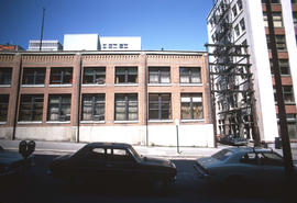
Image shows a portion of the west side of the Pender Building (402 West Pender Street).

Part of City of Vancouver fonds
Image shows Metro Parking building (444 Dunsmuir Street) from east side (with Holy Rosary Cathedral in background).

Part of City of Vancouver fonds
Image shows Metro Parking building (444 Dunsmuir Street) from east side (with Holy Rosary Cathedral in background).
Part of City of Vancouver fonds
Photograph shows the Canada Trust Building (901 West Hastings Street) at the corner of Hornby Street.
Part of City of Vancouver fonds
Image shows Pacific Coast Fire Building (325 Howe Street).

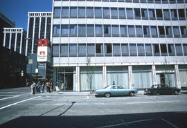
Part of City of Vancouver fonds
Image shows The Bank of Montreal
Part of City of Vancouver fonds
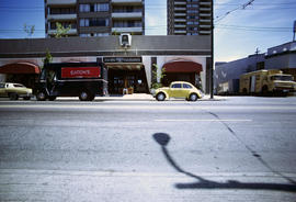
Image shows the entrance to the Pacific Palisades (1277 Robson Street) and Eaton's and Dairyland trucks

Part of City of Vancouver fonds
Image shows east side of the Bank of Nova Scotia Building at Seymour Street and Hastings Street.

Part of City of Vancouver fonds
Image shows a 1 storey commercial building at 803-819 Thurlow Street (Archer Realty Ltd., House of Denmark, Big Iron Cleanersand Busy Bee Flower Shop and Market)
Part of City of Vancouver fonds
Image shows, the foreground, the low parkade at Pender Street & Homer Street, and in the background, the side of the Niagara Hotel (on Pender Street, includes a painted wall advertisement).

Part of City of Vancouver fonds
Photograph shows the Canada Trust Building (901 West Hastings Street).

Part of City of Vancouver fonds
Photograph shows the Nesbitt Thomson Building (890 West Pender Street) from the west side.
![[View of the] 400 block Powell [Street]](/uploads/r/null/a/0/a0f18c3582888b4ad0a19a2c0b50b309a625804443c4447361c8a36271ecdc56/a90e80c8-0bf3-434e-9409-0a4b2be17d6b-A59193_142.jpg)
[View of the] 400 block Powell [Street]
Part of City of Vancouver fonds
Photograph also shows buildings and businesses including Smithfields Quality Meats (451 Powell Street)
![Strath[cona] Rehab[ilitation]](/uploads/r/null/0/2/02b1fed48044b74102e9925a7d95d4e41c852514c6df4fa62c81951fda863407/96950589-6fda-44af-b35b-66aab9e359d9-A59208_142.jpg)
Part of City of Vancouver fonds
Photograph shows houses and apartment buildings on Jackson Avenue and Union Street looking south to Prior.
![[Cordova Street looking west at Jackson Avenue.]](/uploads/r/null/7/b/7b6818d1a76e50216589304905b401c5dedf6da81e2e67f846e8bdbf8f7ab8c7/ae00d516-b739-47f5-b32a-672eb41756a5-A59214_142.jpg)
[Cordova Street looking west at Jackson Avenue.]
Part of City of Vancouver fonds
![[Apartment building in Strathcona]](/uploads/r/null/d/c/dce71af6138063c3359ee3fddf0d99a76204aecf14f9150f92f901bdc94f9893/a7b0b850-9184-4183-ab85-58a62d36836a-A59226_142.jpg)
[Apartment building in Strathcona]
Part of City of Vancouver fonds

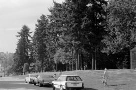
View across tennis courts to site
Part of City of Vancouver fonds
![[Victory Square at 200 West Hastings Street]](/uploads/r/null/4/5/456a2760b63dac643b39d8592c06c8497d358073eb47e6525f4e82b91ad80898/1135e1b5-72d9-406c-b547-65341ebcfa8e-A59639_142.jpg)
[Victory Square at 200 West Hastings Street]
Part of City of Vancouver fonds
Photograph also shows the Victory Building (198 West Hastings Street), the Victory Square Cenotaph (Hastings Street and Cambie Street), and the Canadian Imperial Bank of Commerce (300 West Hastings Street)
![[Building at] 1080 Mainland [Street]](/uploads/r/null/5/7/57c152732ae5dab66cb4166ce7fe27792cbf8db872b2a682721239acef7d2427/7207a1b5-c0bf-44ba-8ac4-945d94faa5e7-A59834_142.jpg)
[Building at] 1080 Mainland [Street]
Part of City of Vancouver fonds
![Rear [view of houses along] Hamilton [Street] between Smithe [Street] and Robson [Street]](/uploads/r/null/9/a/9aa4625880ae56bca6ef7abcc82ded9f1b3437c35b17901c1528db13e441bd4d/9c6d12ff-4db0-42ab-8da3-31f82751cd40-A59837_142.jpg)
Rear [view of houses along] Hamilton [Street] between Smithe [Street] and Robson [Street]
Part of City of Vancouver fonds
![[Building at the corner of West Pender Street and the 400 block Richards Street]](/uploads/r/null/5/b/5b32f6716b913846dd75d9e2aea9ef661e937030b878521e991d714cdce71081/9430612c-b7b8-454d-a00e-169e2a905fa0-A58795_142.jpg)
[Building at the corner of West Pender Street and the 400 block Richards Street]
Part of City of Vancouver fonds
![[Vancouver Resource Building on] 535 Homer [Street]](/uploads/r/null/6/6/66e9d6bba7e61a8b81224c5fa744a1d218217bb7407ce868e3bd8cb28e611913/97f03c44-2c53-49a7-8069-dedaba9b4617-A58819_142.jpg)
[Vancouver Resource Building on] 535 Homer [Street]
Part of City of Vancouver fonds
![[View of the 800 block Granville Street, Theatre Row]](/uploads/r/null/4/2/4262db33137944d1c0ab7530ceadd9e59536311bdbc4bd477388384b9dbf1cba/f89e507e-cfe8-4359-be0f-248beb4bec4e-A58830_142.jpg)
[View of the 800 block Granville Street, Theatre Row]
Part of City of Vancouver fonds
Photograph also shows the Royal Bank (796 Granville Street), the Capitol Theatre (820 Granville Street) and Commodore Lanes Bowling (838 Granville Street)
![[View of the Holy Rosary Cathedral at 646 Richards Street]](/uploads/r/null/b/b/bb3649b12260e23f3aac9bbb69edc981bc5554eb8ad559e1ef31d74181c7fd80/342e5771-2d64-4ba5-909d-7a30990e555d-A58838_142.jpg)
[View of the Holy Rosary Cathedral at 646 Richards Street]
Part of City of Vancouver fonds

Part of City of Vancouver fonds
B.C. EL - R.O.W. (British Columbia Electric Railway Right-of-Way)
Part of City of Vancouver fonds
Item is a photograph showing the BC Electric Railway. Skipper's Japanese restaurant, Bank of Montreal and Gospel Mission at 331 Carrall visible.

B.C. EL - R.O.W. (British Columbia Electric Railway Right-of-Way)
Part of City of Vancouver fonds
Part of City of Vancouver fonds
Part of City of Vancouver fonds
![[Back of] 828 - 830 Main Street](/uploads/r/null/9/0/907064fcd7d3e3df1b4c32db9b244230ee0d84b149842ef49d31d778a1b2322c/7b4cfe39-9dc8-4b82-b8ae-52cc375b7f00-A59010_142.jpg)
[Back of] 828 - 830 Main Street
Part of City of Vancouver fonds
![255 Prior Street [front]](/uploads/r/null/b/0/b0b4614e499b1b64d23aa9b0b7a8d494bfdfecff7fb3cd1d2635d3f25f472da5/f00971d6-b4de-486d-94c1-1794e0c46a24-A59019_142.jpg)
Part of City of Vancouver fonds
Photograph also shows 251 Prior Street.
![248 - 250 Union Street [front]](/uploads/r/null/0/1/014d1dc53b6ed6f8358925afb23cee24e67b65abc293bfe4d445432f1b46aa60/9de497b0-7ec7-4ce4-b5b2-b5a460572ad4-A59040_142.jpg)
248 - 250 Union Street [front]
Part of City of Vancouver fonds
![[Houses at] 278 [Union Street] and 809 Gore [Avenue]](/uploads/r/null/6/4/64100bb23754f1e398e2ba851c15151df6597728236eb8348ffe43b6b2e1704f/b914e1c0-496d-4c85-83e1-0bfa9ce31e90-A59054_142.jpg)
[Houses at] 278 [Union Street] and 809 Gore [Avenue]
Part of City of Vancouver fonds

Looking north on Oak Street at West 16th Avenue
Part of City of Vancouver fonds
Photograph shows construction of the electric street railroad, businesses in the 3100 block Oak Street, Leo Service station (3095 Oak Steet), Huntly Lodge (3050 Oak Street), 3027 Oak Street and Athol Apartments (2970 Oak Street).
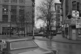
![[Pender Street at Cambie Street, looking west]](/uploads/r/null/3/d/3d91c3d4cd2181022a308d60e8fad6da587efcfa17cc0a68527eb95c215bc009/5a8ff240-1741-4881-b137-7b3a66b98a1d-A43705_142.jpg)
[Pender Street at Cambie Street, looking west]
Part of City of Vancouver fonds
Photograph shows the Vancouver Sun sign, City Health Department building and Central Public School
![[700 E Hastings St]](/uploads/r/null/e/d/ed03592c91e746bd2bdb2f7bd19463f38d2315e8700fb0347925fabcb17aa532/ca970500-4326-4da5-bcd5-c6553ee5fda4-A43723_142.jpg)
Part of City of Vancouver fonds
Photograph shows south side of the 700 Block East Hastings Street as viewed from the north east including the Woodbine Hotel.
![[Looking north from Hastings Street along Hawkes Avenue]](/uploads/r/null/c/6/c6b7721c67508d95616838456d2e6f7fcb948b0917845c03dd2885e884026c85/090e0d28-920a-4794-bafe-7ce84481a5d2-A43725_142.jpg)
[Looking north from Hastings Street along Hawkes Avenue]
Part of City of Vancouver fonds
Photograph shows the National Harbours Board elevator
![Abbott and Cordova [streets looking] west](/uploads/r/null/9/e/9e6ecc370bc289e5be80f2c7024a559ad55f83ec49ec64c8f3a8df89481637f7/f7d058c6-cc09-4ac7-85bf-be6f0d56c87c-A42713_142.jpg)
Abbott and Cordova [streets looking] west
Part of City of Vancouver fonds
Photograph shows Woodwards and the walkway to the parkade
![Abbott and Hastings [streets looking] east](/uploads/r/null/f/a/fa0d67515affc3ab9a0a5625d6d6d6e103e07a6f1a5d936f025bfd1d86416738/bf20e84f-2d2c-4ba3-a778-dfd77978f715-A42715_142.jpg)
Abbott and Hastings [streets looking] east
Part of City of Vancouver fonds
![Abbott and Pender [streets looking] east](/uploads/r/null/f/8/f83eaf09fec1ebf23e21a3db3691921915705e4f383ef44a5027be0102269396/3566daa7-37b0-43c3-96e2-f30d512ad817-A42719_142.jpg)
Abbott and Pender [streets looking] east
Part of City of Vancouver fonds
Photograph shows the Arco Hotel
![Alder and 6th. [Avenue looking] north](/uploads/r/null/b/5/b5e8014aa997d96e6cbf92700ea83aa8dc54d72042b05322e9852ba8ceff9488/44a9a5d1-bf83-4a5b-81ab-2a25d3fa29eb-A42722_142.jpg)
Alder and 6th. [Avenue looking] north
Part of City of Vancouver fonds
![Alder [Street] and 6th [Avenue looking] south](/uploads/r/null/a/e/ae393bfbc80a207f68cd15f0f0b40ecc6636b45191de8f943d48ac6dfb55edf6/a8b1130e-2354-4236-8727-50a9e570eb1b-A42724_142.jpg)
Alder [Street] and 6th [Avenue looking] south
Part of City of Vancouver fonds
Photograph shows Mushroom Studios at 1234 West 6th Avenue
![W Blvd and 37[th Avenue intersection, 7 of 7]](/uploads/r/null/3/9/b/39ba281388109c5d462b4058a66d864463ca5b38d96852c634928df2e67c1a97/635087c3-aa13-43c2-af07-cbda9f2387d5-2019-103.0448_142.jpg)
W Blvd and 37[th Avenue intersection, 7 of 7]
Part of City of Vancouver fonds
![Boundary [Road] and Kingsway [intersection, 1 of 4]](/uploads/r/null/0/2/2/02262cc3e7b316bf51bd9656b28f9e089cfdc4b7a99473fd5c08d4c9302d127c/88cc4727-279d-456f-8e3c-7de3be1c913a-2019-103.0700_142.jpg)
Boundary [Road] and Kingsway [intersection, 1 of 4]
Part of City of Vancouver fonds
![Boundary [Road] and Canada Way [intersection, 4 of 4]](/uploads/r/null/b/c/4/bc43d54bed614afef2be4c9febd5f50b3ce16d5b229b53160db5e7887f126567/3fbfd6d3-6cbc-46b2-ab18-fc032a74bd8b-2019-103.0719_142.jpg)
Boundary [Road] and Canada Way [intersection, 4 of 4]
Part of City of Vancouver fonds
![Boundary [Road] and Lougheed [Highway intersection, 1 of 4]](/uploads/r/null/5/2/e/52e18fe991968bc1dfcb36801aada715afbf37e38985d738e597d7124fe49ddf/5ad5714f-054c-4908-aa04-6c53775679b6-2019-103.0725_142.jpg)
Boundary [Road] and Lougheed [Highway intersection, 1 of 4]
Part of City of Vancouver fonds
![Renfrew [Street] and Broadway [intersection, 2 of 5]](/uploads/r/null/1/e/5/1e5ae76e78bcbea3f1525f4f6e3df8c41fa96cde7bf854d3b005070ce37d74b9/5a6083a3-0299-4034-ab52-8c7889f84ad4-2019-103.0779_142.jpg)
Renfrew [Street] and Broadway [intersection, 2 of 5]
Part of City of Vancouver fonds
![Granville and Dunsmuir [Streets looking] north](/uploads/r/null/1/c/1ca6db6f617906d16039d0447b2ed2741f84079d9ad5845b62394b6da8a5c18d/80829671-64b4-4436-86bb-66ba7af3aba5-A43568_142.jpg)
Granville and Dunsmuir [Streets looking] north
Part of City of Vancouver fonds
![Commercial [Drive] and 12th [Avenue intersection, 2 of 4]](/uploads/r/null/d/a/c/dace718e8586f77ee1a7ad482256ac06ef5017b232bbfd3308a7a8e895e6b20e/7481440e-3eec-4c31-a8bf-cb23c38a3039-2019-103.0014_142.jpg)
Commercial [Drive] and 12th [Avenue intersection, 2 of 4]
Part of City of Vancouver fonds