
Victoria - arborist, waterfront, roses
![Live aboard boats Van[couver] Harbour](/uploads/r/null/1/8/18256dcc44ce8ee821cf0596c7b8cfaed9f1e50d760af6088adfd6323d878b3d/d92aa9ea-8969-4fc4-bfd4-3996a829c822-A59826_142.jpg)
Live aboard boats Van[couver] Harbour
![Marina, Vanc[ouver] Harbour](/uploads/r/null/0/4/04033fe768c44267a675e5e6c027d7483b671d817668ff5ef3ee4a281ea1be9b/12f48c6c-adff-414f-b6b8-439ccdcf73a4-A59827_142.jpg)
Marina, Vanc[ouver] Harbour
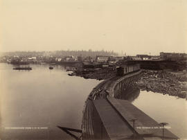
![C.N.R. Pier at Main St[reet] view to East](/uploads/r/null/c/d/cdbc948a1e80a0e86f7c055d1d00d5de4b7775b1a0619918a019cbffeec949e3/908433d2-8391-4308-ace0-d850830623f1-A59832_142.jpg)
C.N.R. Pier at Main St[reet] view to East
![[View of West Coast Shipbuilders Limited from the water]](/uploads/r/null/b/3/b3ba3c009ff130d63fd3f9195d6876a6de8e55dc7b1ebd100f19ffe24a06c151/7157ebfd-cee1-4bd7-95bd-9801915b7204-A46263_142.jpg)
[View of West Coast Shipbuilders Limited from the water]
![[View of West Coast Shipbulders Limited from the water]](/uploads/r/null/5/4/54c087d5d1d4b31e298b702582c0a2bd77fda1b23f27072ece0ee1bd9f7fe2d4/22ed205e-a2df-40ab-9833-bba9ad817f20-A46239_142.jpg)
[View of West Coast Shipbulders Limited from the water]
Vancouver from C.P.R. Docks
![[Apodaca Park (D.L. 4974) and Cove from the water]](/uploads/r/null/f/a/faba6e0b8b4c25db985f0ca724b2a9fedce0624d266f732170d6186c4ab3e826/8d74a0d3-3836-4f71-ab01-50ff1ee8b9d5-A59989_142.jpg)
[Apodaca Park (D.L. 4974) and Cove from the water]
![[Water front view of] Victoria - Vancouver Island]](/uploads/r/null/9/b/9bd7fa4c80a8257c626eeb02c568e3d3fdcfe887feb124cd812a5a42d311ddb7/f7cca73b-6d9e-459b-87c4-c12ac90e3e03-A22901_142.jpg)
[Water front view of] Victoria - Vancouver Island]
![[Waterfront view of Yale - Frazer [Fraser] River](/uploads/r/null/c/b/cb93dac894f555448d19c45ef7ca3ab754bd1169c311d9479183cb3bc3b1ce24/1c23e657-aa7a-49ac-8784-e7f1a94285cb-A22912_142.jpg)
[Waterfront view of Yale - Frazer [Fraser] River
Square at Coquimbo
![[View from the water of Alderman Coldwell's building under construction]](/uploads/r/null/8/c/8c8a58447efc5758170db86a52f5ab5566649d818fe3e4545fa31a34a4c2fada/2aad2cc6-3d5c-4c21-9649-a7e3a5294861-A61276_142.jpg)
[View from the water of Alderman Coldwell's building under construction]
![[View from the water of ships and docks east of the second C.P.R. Station]](/uploads/r/null/8/1/8138acc237d37e437c9a7265ee5840730c52d26418e28584efc91eed2b63371a/2716de57-d5ff-4437-8800-89cb99d5721f-A60106_142.jpg)
[View from the water of ships and docks east of the second C.P.R. Station]
![[View of Bainbridge Ranch from Burnaby Lake]](/uploads/r/null/f/a/fa0788db653abd785d8eef1dfda31947db088dcc5802fa6631fb04006a2f7559/38ca2d54-1361-4e79-bca3-e111b52f709b-A59968_142.jpg)
[View of Bainbridge Ranch from Burnaby Lake]

A section of Vancouver's waterfront

Coquitlam Dam
![Coquitlam Dam [showing] view of tunnel camp](/uploads/r/null/3/f/3fa21b8b9d44758f5c1ffeffe8985532e9173b838e6fcc44734fbc2121bc6f36/465a9fca-bb7d-4c82-873f-db9330f2b53c-A32883_142.jpg)
Coquitlam Dam [showing] view of tunnel camp

Coquitlam Dam looking north towards tunnel camp on west shore of lake showing ground cleared and ready for burning
![[Point Grey Partnership Pipe project - False Creek Section]](/uploads/r/null/3/2/32a92ca46baf9d0be596bd3ef1744b7f1bb9b40366228d328bf670af8c7e124a/3e0d525d-9cce-4516-b35b-b98f22d54024-A60135_142.jpg)
[Point Grey Partnership Pipe project - False Creek Section]
![[Point Grey Partnership Pipe project - False Creek Section]](/uploads/r/null/9/9/99353b887dbdadad92c8a2b00c7fedb401ac4dd3025f75a6bc0e30525a0071d5/ac669d19-42e3-40cb-93df-242bc9968bd3-A60138_142.jpg)
[Point Grey Partnership Pipe project - False Creek Section]
![[Buntzen Lake Dam site]](/uploads/r/null/f/a/fa372281f97b8965b65626e2452f691db179033f7cdbf258594acac6b4f7e913/c50187c3-07b2-4f59-a12a-0a325b53c7a3-A23298_142.jpg)
[Buntzen Lake Dam site]
![[Log hitting water from chute in logging camp]](/uploads/r/null/e/a/ea0b19f5ef9a9c374cd31dd45e958daa08eb4c4e25a7ff9bac98d8adf2f1832b/deed2cf7-0b50-47d4-b315-5924134693fb-A31963_142.jpg)
[Log hitting water from chute in logging camp]
![[Looking east from the bluff near the foot of Howe Street]](/uploads/r/null/5/5/5537f72daeab55074b4c663dae9afe1b2868ad2b8a27bfabce92ba0e2cd35f10/17cdbde0-bfd0-48c0-8592-1e430be93907-A43309_142.jpg)
[Looking east from the bluff near the foot of Howe Street]
![[Looking north across False Creek from 8th Avenue between Alder Street and Spruce Street]](/uploads/r/null/b/f/bfbfdda073909ac3a8b7fe81c7d8a986770772ac8fdcfef25af14dca17a87a19/d7b8ac67-cd53-4df6-a8a2-3c59dcd146d8-A43223_142.jpg)
[Looking north across False Creek from 8th Avenue between Alder Street and Spruce Street]
![Sea Island, mouth of [north arm of] Fraser River at Marpole, photos taken for R.M. Grauer](/uploads/r/null/b/0/b0f85e3b55b528e064c69c84c4614d3565eddcaf364a1b4aaafb7768ae1f73c7/3e38bd07-1db6-45a8-8894-a3bed3d5034d-A01180_142.jpg)
Sea Island, mouth of [north arm of] Fraser River at Marpole, photos taken for R.M. Grauer
![Sea Island, mouth of [north arm of] Fraser River at Marpole, photos taken for R.M. Grauer](/uploads/r/null/6/1/61d7efb9b6bc26f862a433aaba5a5e683c5b39f036e21f47da1a53bbdfae8cbc/b769a960-aee3-4cf7-be77-4c24708e0ab7-A01181_142.jpg)
Sea Island, mouth of [north arm of] Fraser River at Marpole, photos taken for R.M. Grauer
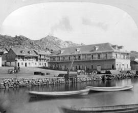
![[View of Selma Park dock and cottages]](/uploads/r/null/e/3/e/e3e9d27390948e2af6233a0bbe4c8160edf7ab2f5d9944710fb7960e25f0ac52/419e58c8-fa74-415b-9397-a12bc858ae24-CVA374-449_142.jpg)
[View of Selma Park dock and cottages]

Houses built on rocky terraces, Ocean Falls

Mount Gardner Park, Bowen Island, B.C.

New Westminster, B.C. from the waterfront

Siwash Rock

The Harbour, Vancouver, B.C.
![[North Vancouver from Burrard Inlet]](/uploads/r/null/f/2/f285dd5633144f255b287145d9cec78b096827c3110720acace67fe73e7d654a/b97f757f-39e2-4c8f-9352-a095c360e4fe-A02535_142.jpg)
[North Vancouver from Burrard Inlet]
![[View of downtown Vancouver and waterfront from above, showing Marine Building under construction]](/uploads/r/null/8/6/86680d24afa6725e26cf86f7f036e9815677dd146b76bc60b8f6ca6d82e69d2c/3adf3f30-5dd9-4268-871f-b68de7c89733-A02521_142.jpg)
[View of downtown Vancouver and waterfront from above, showing Marine Building under construction]

Mimulus on cliffs, Pacific Rim
![[View of ocean and islands, Stuart Island, B.C.]](/uploads/r/null/2/6/26a2cc71eb87d5cd592e51acf2de1a42175a49eb5c574f0c6e9655e13db6e820/75b19879-5802-42b3-819a-3526c42f44d0-CVA1477-859_142.jpg)
[View of ocean and islands, Stuart Island, B.C.]
![[View of shoreline, Stuart Island, B.C.]](/uploads/r/null/e/6/e6536c52cf201abc09e2bd7d743daec1c314a8a7d570d73f3bd4c49c61f4dc0b/89720f15-da7a-4822-af02-5c9912a23ca0-CVA1477-849_142.jpg)
[View of shoreline, Stuart Island, B.C.]
![[View of water near George J. Fowler's summer home]](/uploads/r/null/f/5/f5fe0c6e0c2c15f1c2675483ca493916ec352f2119f7cae159ded55813822717/fbc73340-1c9a-48ee-8f6d-98ef259fc1bb-CVA1477-830_142.jpg)
[View of water near George J. Fowler's summer home]

[View of the North Arm of the Fraser River showing Eburne Gravel Co. and Eburne Sash, Door and Lumber at the foot of Hudson St.]
![[Waterfront view from Burrard Inlet]](/uploads/r/null/c/5/c59ed6bbc7f7461c425bdb82a570bb2a6290f2a0d43bf3c9c4e6baa0607acdfc/11532f87-661c-40a7-8c19-77d3b73fc7e2-A63182_142.jpg)
[Waterfront view from Burrard Inlet]
![[Waterfront view from Burrard Inlet]](/uploads/r/null/9/3/931798c2d82bb204d36b1481f93e144725bff9e21879776b03302660f3cc2ac9/b94e500c-c940-4b0c-b50c-509ca6500837-A63949_142.jpg)
[Waterfront view from Burrard Inlet]
![[Waterfront view of Redonda Canning Co.]](/uploads/r/null/1/4/143dda79bdcb1cb6486632f4b92b25aaa8bcf6571879dd78569cf7dfa3700107/4de81ce2-4516-4cb1-aae7-3af0aa6e5e1b-A63623_142.jpg)
[Waterfront view of Redonda Canning Co.]
![[Aerial view looking east of downtown Vancouver and the waterfront]](/uploads/r/null/a/1/a146c28159c45997dd3312d8a94967907da12e5b5c1139902f95665ab0e54675/740905a3-6e61-4ffc-bc08-d90ad82bc7d8-A67011_142.jpg)
[Aerial view looking east of downtown Vancouver and the waterfront]
![[Aerial view looking south of the] District of North Vancouver [between Seymour and Lynn Creeks]](/uploads/r/null/e/f/efec87eb86f83a0865fb63dd855e51942b3f5e6b75c5f105b15ef3db57d5b5c9/107091fb-3414-4f25-bc79-e59cee44fbab-A23496_142.jpg)
[Aerial view looking south of the] District of North Vancouver [between Seymour and Lynn Creeks]
![[Aerial view of Burrard Inlet, Vancouver waterfront and North Vancouver waterfront]](/uploads/r/null/7/e/7ebb42bad115eb635562fde51fb418b1e63ecf9048f15193681f167f6966c96a/874ecdbf-b7e9-4561-b45f-1003efcc073f-A66601_142.jpg)
[Aerial view of Burrard Inlet, Vancouver waterfront and North Vancouver waterfront]

[Aerial view of North Vancouver, First Narrows, Stanley Park, West End, Coal Harbour, Burrard Inlet, Vancouver Waterfront and Downtown]
![[Aerial view of Vancouver looking east]](/uploads/r/null/9/3/93309104da24ef0ea4391055c01c783c88d8d52c9939ee604b894d907555df68/564df6c6-3fbe-40b9-bba9-6386ae62ff3c-A23479_142.jpg)
[Aerial view of Vancouver looking east]
![[A lumber mill from the water]](/uploads/r/null/9/a/9a3e83f9ead48058f1e8ba31217e8ac8a7ba46b819317c71b69217ddccd68d4e/c0238c72-74ef-400e-8bf3-9db8e09e704d-A33159_142.jpg)
[A lumber mill from the water]

Waterfront Vancouver, B.C.
![[Surf crashing on rocks]](/uploads/r/null/6/3/4/6349ab266547894d5a424f9b9410b53789d6b55fe605dbdc6f624a886dd67922/e3162944-7f1e-4b79-923a-92e27f4714cd-CVA371-2911_142.jpg)
[Surf crashing on rocks]