Add to clipboard
The Canadian Pacific Rockies
Add to clipboard
Free map of Vancouver, New Westminster and surroundings
Add to clipboard
Road map of Saskatchewan and Manitoba, highway map of southern Canada and the northern United States, and information on national parks in western Canada
Add to clipboard
City of Vancouver [park sites June/80]
Add to clipboard
City of Vancouver
Add to clipboard
City of Vancouver
Add to clipboard
City of Vancouver, British Columbia
Add to clipboard
City of Vancouver, British Columbia
Add to clipboard
Stanley Park, Vancouver, B.C.
Add to clipboard
Grouse Mountain Park. North Vancouver, B.C.
Add to clipboard
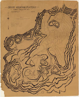
Grouse Mountain Plateau, North Vancouver, B.C.
Add to clipboard
Standard tourists' guide to Stanley Park, Vancouver, B.C.
Add to clipboard
[Sheet 4 : Chilco Street to Burrard Street and Robson Street to Deadmans Island]
Add to clipboard
[Sheet 5 : Stanley Park to Nicola Street and English Bay Beach to Robson Street]
Add to clipboard
[Sheet 6 : Nicola Street to Beatty Street and English Bay Beach to Georgia Street]
Add to clipboard
[Sheet 7 : Burrard Street to Main Street and Georgia Viaduct to Burrard Inlet]
Add to clipboard
[Sheet 9 : Main Street to Clark Drive and Prior Street to Burrard Inlet]
Add to clipboard
[Sheet 10 : Clark Drive to Nanaimo Street and Frances Street to Burrard Inlet]
Add to clipboard
[Sheet 11 : Wall Street to Rupert Street and McGill Street to Burrard Inlet]
Add to clipboard
[Sheet 13 : Rupert Street to Gilmore Avenue and Eton Street to Burrard Inlet]
Add to clipboard
[Sheet 14 : Cassiar Street to Carleton Avenue and Pender Street to Eton Street]
[Sheet 17 : Nanaimo Street to Rupert Street and Charles Street to Pender Street]
Add to clipboard
[Sheet 17 : Nanaimo Street to Rupert Street and Charles Street to Pender Street]
Add to clipboard
[Sheet 18 : Nanaimo Street to Rupert Street and Fifth Avenue to Charles Street]
Add to clipboard
[Sheet 19 : Clark Drive to Nanaimo Street and Second Avenue to Frances Street]
[Sheet 20 : Main Street to Clark Drive and Great Northern Way to Prior Street]
Add to clipboard
[Sheet 20 : Main Street to Clark Drive and Great Northern Way to Prior Street]
Add to clipboard
[Sheet 22 : Maple Street to Drake Street and Fourth Avenue to Thurlow Street]
Add to clipboard
[Sheet 23 : Balaclava Street to Maple Street and Third Avenue to English Bay]
Add to clipboard
[Sheet 24 : Jericho Beach to Balaclava Street and Fourth Avenue to Cameron Avenue]
Add to clipboard
[Sheet 25 : Blanca Street to Jericho Beach and Fourth Avenue to Locarno Beach]
Add to clipboard
[Sheet 27 : University Endowment Lands and Drummond Drive to Camosun Street and Fourteenth Avenue to Fourth Avenue]
[Sheet 28 : Camosun Street to Balaclava Street and Fourteenth Avenue to Fourth Avenue]
Add to clipboard
[Sheet 28 : Camosun Street to Balaclava Street and Fourteenth Avenue to Fourth Avenue]
Add to clipboard
[Sheet 30 : Maple Street to Oak Street and Fourteenth Avenue to Third Avenue and False Creek]
[Sheet 31 : Oak Street to Main Street and Sixteenth Avenue to Fourth Avenue and False Creek]
Add to clipboard
[Sheet 31 : Oak Street to Main Street and Sixteenth Avenue to Fourth Avenue and False Creek]
Add to clipboard
[Sheet 32 : Main Street to Clark Drive and Sixteenth Avenue to Great Northern Way]
Add to clipboard
[Sheet 33 : Clark Drive to Nanaimo Street and Thirteenth Avenue to Second Avenue]
Add to clipboard
[Sheet 36 : Rupert Street to Carlton Avenue and Twenty-second Avenue to Grandview Highway]
Add to clipboard
[Sheet 37 : Rupert Street to Carleton Avenue and Wellington Avenue to Twenty-second Avenue and Elmwood Street]
Add to clipboard
[Sheet 38 : Nanaimo Street to Rupert Street and Twenty-second Avenue to Grandview Highway]
Add to clipboard
[Sheet 39 : Kingsway and Nanaimo Street to Rupert Street and Ward Street to Twenty-second Avenue]
Add to clipboard
[Sheet 40 : Inverness Street to Nanaimo Street and Twenty-second Avenue to Thirteenth Avenue]
Add to clipboard
[Sheet 41 : Ontario Street to Inverness Street and Twenty-eighth Avenue to Sixteenth Avenue]
Add to clipboard
[Sheet 42 : Oak Street to Ontario Street and Twenty-eighth Avenue to Sixteenth Avenue]
Add to clipboard
[Sheet 43 : East Boulevard to Oak Street and Laurier Avenue to Fourteenth Avenue]
Add to clipboard
[Sheet 44 : Blenheim Street to Arbutus Street and King Edward Avenue to Fourteenth Avenue]
Add to clipboard
[Sheet 45 : Discovery Street to Blenheim Street and King Edward Avenue to Fourteenth Avenue]
Add to clipboard
[Sheet 47 : Camosun Street to Blenheim Street and Thirty-third Avenue to King Edward Avenue]
[Sheet 48 : Blenheim Street to Arbutus Street and Thirty-third Avenue to Twenty-third Avenue]
Add to clipboard
[Sheet 48 : Blenheim Street to Arbutus Street and Thirty-third Avenue to Twenty-third Avenue]
[Sheet 49 : Arbutus Street to Oak Street and Thirty-third Avenue to Laurier Avenue]
Add to clipboard
[Sheet 49 : Arbutus Street to Oak Street and Thirty-third Avenue to Laurier Avenue]
Add to clipboard
[Sheet 50 : Oak Street to Ontario Street and Thirty-seventh Avenue to Twenty-eighth Avenue]
Add to clipboard
[Sheet 51 : Ontario Street to Inverness Street and Thirty-seventh Avenue to Twenty-eighth Avenue]


![City of Vancouver [park sites June/80]](/uploads/r/null/9/4/9484add7c4684ea3838e4d00ee8add3ecf85d78d5aa8fe2780cae273e59556a5/bd2464d8-2aa9-4501-aba6-8b3f7d130a42-MAP1032_142.jpg)


![[Sheet 4 : Chilco Street to Burrard Street and Robson Street to Deadmans Island]](/uploads/r/null/9/4/9482209e02b8dc04c79ef404276e1d40bcbb4fab0330b4aa744e352ae9440921/5597738a-70b2-4cfc-a802-6a076987c33d-MAP339_142.jpg)
![[Sheet 5 : Stanley Park to Nicola Street and English Bay Beach to Robson Street]](/uploads/r/null/1/d/1daf1ff2196704e4e82a6b5c7476ee3e8a46b4e0740f3c37f3f58813f5f8b5f0/ee3a2706-4ebe-4ee8-b4db-da89840c7f89-MAP339_142.jpg)
![[Sheet 6 : Nicola Street to Beatty Street and English Bay Beach to Georgia Street]](/uploads/r/null/f/2/f2effc97084427c0bd73bae3566d3ad910caaa6e7fb3e5ed9f3ece81bd2ac0a1/f2cc48a6-1195-4dd8-8227-71d36d1791bb-MAP339_142.jpg)
![[Sheet 7 : Burrard Street to Main Street and Georgia Viaduct to Burrard Inlet]](/uploads/r/null/c/d/cd235086cbaf81487b8784fb32b6ef913f4fe27305678cd1961adf506324c250/8f72f6bd-1013-48ad-a56c-e6269cb6f5a8-MAP339_142.jpg)
![[Sheet 9 : Main Street to Clark Drive and Prior Street to Burrard Inlet]](/uploads/r/null/c/a/ca4b4713bea0118fec812e6258afe5c1efa039db74073214703001a47b00f122/5e0d243a-99ae-42aa-8bb3-4a1abe9e1209-MAP339_142.jpg)
![[Sheet 10 : Clark Drive to Nanaimo Street and Frances Street to Burrard Inlet]](/uploads/r/null/b/1/b1095cb557ec54cc1f1894faad721045c1eaa4b11b76e6c08ec0349a9138f078/f41cbf9e-303f-40cd-8ef4-f0699363222c-MAP339_142.jpg)
![[Sheet 11 : Wall Street to Rupert Street and McGill Street to Burrard Inlet]](/uploads/r/null/e/b/eb84fb8de9ca2e1644a2e39bcbaad5253c563e8716cf25114e675fb7d40365ea/0935fb81-4662-411a-bdfd-c9823c7fb82b-MAP339_142.jpg)
![[Sheet 13 : Rupert Street to Gilmore Avenue and Eton Street to Burrard Inlet]](/uploads/r/null/f/0/f03aaa2671556fb722cf612a9736c0a6b919aff4af5a9dbe048dd93863af5773/30eb2a4c-b404-4552-81da-7461e4aacfaa-MAP339_142.jpg)
![[Sheet 14 : Cassiar Street to Carleton Avenue and Pender Street to Eton Street]](/uploads/r/null/a/4/a404347152c9328da5ec443862d19bc937a2199f1ce3cde01729819bfd1272d2/5ec2b15f-3c41-4c16-8567-f00ced74929f-MAP339_142.jpg)
![[Sheet 18 : Nanaimo Street to Rupert Street and Fifth Avenue to Charles Street]](/uploads/r/null/d/1/d1f15643f64f1017cebdf5df98ddf5f7c38a6db5ade26e6b203290dc663fd504/8b6604fc-f1c3-4c90-8e0e-7996e05e2419-MAP339_142.jpg)
![[Sheet 19 : Clark Drive to Nanaimo Street and Second Avenue to Frances Street]](/uploads/r/null/6/e/6ead2ad53e7927dc776c7c6e209eaf9f3e6dc61a60b191a0180e7c1e60ef8ace/46817199-aca3-4b79-afda-f95b0d9f2f0b-MAP339_142.jpg)
![[Sheet 22 : Maple Street to Drake Street and Fourth Avenue to Thurlow Street]](/uploads/r/null/4/2/42281b3ab55033f1c62b4ea532ffecc218f82690d1735cd3bb58cfbb1c9a5424/cb682ac6-121a-4bac-99a4-5470e73d38f4-MAP339_142.jpg)
![[Sheet 23 : Balaclava Street to Maple Street and Third Avenue to English Bay]](/uploads/r/null/3/a/3a54a965065dcf8e280a31b4062305fcb93608d40098e982820d383458c84410/0437e9bd-e467-4a81-83ee-f6e9e7ec43b2-MAP339_142.jpg)
![[Sheet 24 : Jericho Beach to Balaclava Street and Fourth Avenue to Cameron Avenue]](/uploads/r/null/e/7/e737857a87702a8fbd029d7bdb109697279cac537d45931818415e380dd2867c/67258081-9a3b-44c0-9191-8a3719f6c999-MAP339_142.jpg)
![[Sheet 25 : Blanca Street to Jericho Beach and Fourth Avenue to Locarno Beach]](/uploads/r/null/a/a/aa0a0c46231b6c2f088187b2268cd829388fc6dd96aa8123f7a8f43d92c642cb/395c09b4-af3a-4986-8987-c83c92a27d94-MAP339_142.jpg)

![[Sheet 30 : Maple Street to Oak Street and Fourteenth Avenue to Third Avenue and False Creek]](/uploads/r/null/2/f/2f9cbcb3930282909d8a62f01384c5c21cf803594c41529ced8de9bed70e9575/e94bfa39-bc0b-46aa-9bdd-b2c0b97f5eba-MAP339_142.jpg)
![[Sheet 32 : Main Street to Clark Drive and Sixteenth Avenue to Great Northern Way]](/uploads/r/null/1/2/1275197193b0488ed8a599413ce061f9bd30140e8bcc64728b9f05c994d8909a/718a0877-7ea9-4090-a67c-7e61c28e238e-MAP339_142.jpg)
![[Sheet 33 : Clark Drive to Nanaimo Street and Thirteenth Avenue to Second Avenue]](/uploads/r/null/5/e/5ef811f96e8c284708c2b73dafde35219a65ddca967ebd7473adfc3e76a171d6/a1b4e29f-54ea-431a-8eff-df608d7e60ff-MAP339_142.jpg)
![[Sheet 36 : Rupert Street to Carlton Avenue and Twenty-second Avenue to Grandview Highway]](/uploads/r/null/2/a/2a5d48ee373aa9984afbf5119a86658558d79c8c5df27b60fdf83e4bb2673a3d/2b3f592c-cadf-4bac-a188-0a08249104da-MAP339_142.jpg)

![[Sheet 38 : Nanaimo Street to Rupert Street and Twenty-second Avenue to Grandview Highway]](/uploads/r/null/c/a/cad90f0f77fa879900b59b4a35c25c5e44009065121168e70a62d613ae189442/cb54334e-9bba-4633-aa5c-0d322a73ef41-MAP339_142.jpg)
![[Sheet 39 : Kingsway and Nanaimo Street to Rupert Street and Ward Street to Twenty-second Avenue]](/uploads/r/null/0/4/0409c276b1c046750a9680e1310ce46ec18fce0f1dfc928aab80fbe273730918/665972e9-723b-462b-b30f-95f1484b2c51-MAP339_142.jpg)
![[Sheet 40 : Inverness Street to Nanaimo Street and Twenty-second Avenue to Thirteenth Avenue]](/uploads/r/null/9/3/9367a0c50f6fa513d717a1972b1bac72acde6d41b002fefcf48ddbd8c8122e8a/c7bfac0b-bf44-441b-b059-fd7bbc0bd4a0-MAP339_142.jpg)
![[Sheet 41 : Ontario Street to Inverness Street and Twenty-eighth Avenue to Sixteenth Avenue]](/uploads/r/null/c/2/c22ca2538905633f64373261ce970df6216075ce4de9e22d491c2e212ce17c1f/616ab944-e39a-4c66-abb4-918b17cc3252-MAP339_142.jpg)
![[Sheet 42 : Oak Street to Ontario Street and Twenty-eighth Avenue to Sixteenth Avenue]](/uploads/r/null/c/7/c7489c984c3ec99abcbb22a87a294856654f9c25046416db253386367e8f4001/9f397dcd-244e-47bf-8acc-e4ae1dcd8a0d-MAP339_142.jpg)
![[Sheet 43 : East Boulevard to Oak Street and Laurier Avenue to Fourteenth Avenue]](/uploads/r/null/8/8/8846e3e6c19438103b656786c264d5dcccc37b59de3cf8fa85bb05f01b65d8f9/9fb3d6cb-93e9-48d0-be52-05cc55ad4ec4-MAP339_142.jpg)
![[Sheet 44 : Blenheim Street to Arbutus Street and King Edward Avenue to Fourteenth Avenue]](/uploads/r/null/2/f/2fdf5060ec6fdc47756dc75416312dd42047abea2beed2d99f086c73bd0c8726/2fe0f45d-ad6c-46e6-9a9f-50c795523f5f-MAP339_142.jpg)
![[Sheet 45 : Discovery Street to Blenheim Street and King Edward Avenue to Fourteenth Avenue]](/uploads/r/null/7/b/7b9edfc2a053f0ba6c95af404ad3bf4f22a5e63ff6ddcd9acea2fd6dc469d916/ef5279fc-e406-412e-9886-eddb46d44c27-MAP339_142.jpg)
![[Sheet 47 : Camosun Street to Blenheim Street and Thirty-third Avenue to King Edward Avenue]](/uploads/r/null/5/9/59c6b01a85dc6051f7cfecf1f33eb7e7017beb24d0dd57b512fcddc2063e3e8f/eabe5a9f-362b-46a4-9efc-275f9b96459b-MAP339_142.jpg)
![[Sheet 50 : Oak Street to Ontario Street and Thirty-seventh Avenue to Twenty-eighth Avenue]](/uploads/r/null/a/3/a3b7d0414ced2d15d401c5747a576809010cc56bb00c564251adecdb35091358/01957154-6807-4889-bc0f-a1f2455ab066-MAP339_142.jpg)
![[Sheet 51 : Ontario Street to Inverness Street and Thirty-seventh Avenue to Twenty-eighth Avenue]](/uploads/r/null/3/a/3aee300fe6dd39cf02ce71f3cbf8199220cf19dc59148fcf8db71a0bdc7f8239/c1783bd2-c47b-43ed-a71d-29571b121241-MAP339_142.jpg)