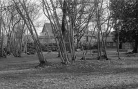
![[Park in Kitsilano]](/uploads/r/null/5/0/50865667f2f73aaa6f5a1276ba9d89dff63332daa130139ff3cf4a79afb9dec7/438ccbe4-ec5f-4389-b02a-3538e004f960-A58937_142.jpg)
[Park in Kitsilano]
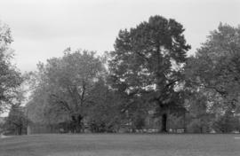
![[Point Grey Road Waterfront Park]](/uploads/r/null/c/9/c9faa13bb2b8c2f0c429b90d90f959707687ba72f7bd3c75e051e307f14f8b61/85333e38-c299-4184-ad33-fece41a848f0-A58944_142.jpg)
[Point Grey Road Waterfront Park]
![Ferguson Point Tea House [at Stanley Park]](/uploads/r/null/c/2/c2c6330864dca9869e9efa4d567e3a7bd0f62399f0554151079563dd58be4f56/5178db50-19f1-4141-b72a-5b06e1d8d20e-A59807_142.jpg)
Ferguson Point Tea House [at Stanley Park]
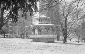
![[Stanley Park] Pavilion](/uploads/r/null/8/5/8515ca88322b135953f3ba323fe72c84f088d2ec9e18bc3284d6be5f1ac3ca45/055e1d0d-7e33-4a4d-95ed-838e3f39cb05-A59808_142.jpg)
[Stanley Park] Pavilion
![[View of English Bay and the West End from Stanley Park]](/uploads/r/null/1/e/1ee06fda871d25f8847c00c3c4b6c702e48b44a63f2ad4de67a86b87823ffb9c/04dee418-9e62-484e-8bf1-b3287a13aba5-A59815_142.jpg)
[View of English Bay and the West End from Stanley Park]
![[Park in the West End]](/uploads/r/null/3/d/3dad80ee0d6f8a595572501c5dbf904b08690829d9a02b2491ce2c6a73a886cd/f2a58b6c-d987-44cf-b30a-4302576d561d-A59277_142.jpg)
[Park in the West End]

Jericho Park
![[Cityscape of Kitsilano looking North]](/uploads/r/null/2/0/20a1900669c168d04ff275a3805145786dc47a4943e313105af3e5000e9617fc/af1fdd04-91e0-4295-a233-74504a743335-A58955_142.jpg)
[Cityscape of Kitsilano looking North]
![Corner Dunlevy [Avenue] and Powell [Street] Oppenheimer Park](/uploads/r/null/5/e/5e2c24ea07e01c23c25892784877e9a3be5d15b8555f00e28611a49c07704b64/f536c908-7c91-416d-bccb-8e97f2719fb0-A59237_142.jpg)
Corner Dunlevy [Avenue] and Powell [Street] Oppenheimer Park

Vancouver skyline, Coal Harbour, and Stanley Park seawall beach

Vancouver skyline, Coal Harbour, and Stanley Park seawall beach

South False Creek Seawall

South False Creek Seawall

Portal Park with view of North Shore

Portal Park with view of North Shore

Portal park during construction
1700 block Beach Avenue

New McLean park in foreground, 700 block Keefer in background

McLean Park with 700 Block Keefer in background

Sheet 10 : Clark Drive to Slocan Street and Burrard Inlet to Triumph Street

Sheet 8 : McLean Drive to Slocan Street and William Street to Seventh Avenue

Sheet 16 : Maple Street to Oak Street and False Creek to Sixteenth Avenue

Sheet 18 : Trutch Street to Maple Street and English Bay to Third Avenue

Sheet 21 : Burrard Street to False Creek and waterfront to Robson Street

Sheet 6 : Knight Street to Slocan Street and Eighteenth Avenue to Twenty-ninth Avenue

Sheet D : Imperial Street to Trutch Street and Fourth Avenue to Sixteenth Avenue

Sheet G : Trafalgar Street to Granville Street and Sixteenth Avenue to Nanton Avenue

Sheet X : Marine Drive to Ash Street and Fifty-ninth Avenue to Seventy-first Avenue

Sheet 6 : Craddock Street to Boundary Road and Twenty-ninth Avenue to Fortieth Avenue

Sheet 3 : Cambie Street to St. George Street and Twenty-seventh Avenue to Thirty-eighth Avenue

Sheet 13 : Fleming Street to Carlton Street and Forty-seventh Avenue to Fifty-ninth Avenue

Sheet 11 : Cambie Street to St. George Street and Forty-seventh Avenue to Fifty-eighth Avenue

Sheet 9 : Fleming Street to Carlton Street and Thirty-seventh Avenue to Forty-eighth Avenue

Oppenheimer Park
Un-named trees, Sunnyside Park (N.I.I.)

Ulmus sp. Sunnyside Park

Memorial Park South, Cenotaph

Unknown vegetation and associated plaque, Queen Elizabeth Park, near West 37th Avenue and Cambie Street entrance

Stanley Park, Kiwanis Club Rose Plot

Stanley Park, Brockton Point Lighthouse

Stanley Park, Brockton Point Lighthouse
Tatlow Park, interior, looking east - Vine Maples
Berm near Lion's Gate Bridge

Pauline Johnson memorial

David Oppenheimer memorial, front view

MacDonald Park, Tennis Courts

Oak Park, looking west - Row of Big Leaf Maples
Almond Park Substation
Almond Park path on bank (not well articulated)

Stanley Park - Japanese Canadian War Memorial, north side