Print preview Close

Showing 280 results

Archival description
City of Vancouver Archives technical and cartographic drawing collection Parks English
Print preview View:

263 results with digital objects Show results with digital objects

Map of Stanley Park [site plan]

Item is a copy of a published map of Stanley Park which has been annotated to show proposed redevelopment plan for the western portion of Coal Harbour (currently Lost Lagoon) and surrounding area. It is believed that this is one of the sheets referred to by Thomas Mawson in his report to the Board of Parks Commissioners regarding various proposed development schemes for the entrance to Stanley Park and the Coal Harbour area.

Commercial map of Greater Vancouver and district

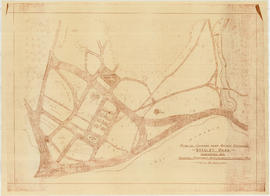
Item is a map sheet containing two maps. The principal map depicts greater Vancouver, including portions of North and West Vancouver, Richmond and Surrey. The information depicted on the map includes streets, postal blocks, streetcar and railway lines, parks and golf courses, and schools. The map includes 1/2 mile distance circles centred on old City Hall at Main and Hastings.

The sheet includes an inset map of Granville Island. Depth of water given along shorelines of Burrard Inlet, English Bay, and along the West Vancouver coast from First Narrows to Howe Sound. The sheet includes an index of streets.
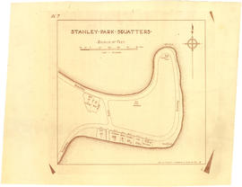
Guide to Vancouver

Item is a pamphlet advertising BC Electric City routes, including observation car routes conducted by Teddy Lyons. The front side of the unfolded pamphlet includes information on City streetcar routes and interurban routes. The reverse side includes information on routes to major attractions and a map of Vancouver showing routes and attractions.

Sheet 7 : Clark Drive to Slocan Street and Seventh Avenue to Eighteenth Avenue

Item is a section showing the area from Clark Drive to Slocan Street and Seventh Avenue to Eighteenth Avenue. Includes streets and roads, blocks, lots, legal descriptions, railways, parks and schools. Some annotations have been made in green ink.

Vancouver (B.C.). Office of the City Engineer

Sheet 6 : Knight Street to Slocan Street and Eighteenth Avenue to Twenty-ninth Avenue

Item is a section showing the area from Knight Street to Slocan Street and Eighteenth Avenue to Twenty-ninth Avenue. Includes streets and roads, blocks, lots, legal descriptions, railways, parks and schools. Some annotations have been made in pencil.

Vancouver (B.C.). Office of the City Engineer

Sheet 12 : Ontario Street to Clark Drive and Keefer Street to Second Avenue

Item is a section showing the area from Ontario Street to Clark Drive and Keefer Street to Second Avenue. Includes streets, roads, blocks, lots, legal descriptions, railways, parks and schools. Includes Terminal Avenue and land used by the Great Northern Railway and the Canadian National Railway.

Vancouver (B.C.). Office of the City Engineer

Sheet 4 : Prince Edward Street to Bruce Street and King Edward Avenue to Thirty-sixth Avenue

Item is a section showing the area from Prince Edward Street to Bruce Street and King Edward Avenue to Thirty-sixth Avenue. Map shows streets, roads, blocks, lots and legal descriptions, and the locations of parks, schools and Mountainview Cemetery.

Vancouver (B.C.). Office of the City Engineer

Guide map: Vancouver - New Westminster, Burnaby and North Shore municipalities

Item is a street map of Vancouver, Burnaby, New Westminster and the North Shore showing city limits and boundaries of central office areas. Map has been annotated to show the old and new Vancouver telephone exchange boundaries prior to and after the introduction of flat rate service on November 1, 1937.

Sheet 1: Slocan Street to Boundary Road and Triumph Street to Burrard Inlet

Item is a section showing the area bound by Slocan Street, Boundary Road, Triumph Street and the waterfront. Includes streets, roads, railways, blocks, lots, legal descriptions, quit claims, leases, parks and businesses along the waterfront.

Vancouver (B.C.). Office of the City Engineer

Sheet 19 : Maple Street to Richards Street and Drake Street to Third Avenue

Item is a section showing Maple Street to Richards Street and Drake Street to Third Avenue. Includes streets, roads, blocks, lots, legal descriptions, parks, schools, the Burrard and Granville Street Bridges, C.P.R. right-of-ways, the Squamish Band reserve, C.P.R. leases and property, and government reserve. Map includes Granville Island.

Vancouver (B.C.). Office of the City Engineer

Sheet S.V. 3 : Cambie Street to St. George Street and Twenty-seventh Avenue to Thirty-eighth Avenue

Item is a section showing the area from Cambie Street to St. George Street and Twenty-seventh Avenue to Thirty-eighth Avenue. Map shows streets, roads, blocks, lots and legal descriptions and the locations of parks, schools, reservoirs and Mountainview Cemetery.

Vancouver (B.C.). Office of the City Engineer

Sheet 5 : Dumfries Street to Fairmont Street and Twenty-seventh Avenue to Thirty-seventh Avenue

Item is a section showing the area from Dumfries Street to Fairmont Street and Twenty-seventh Avenue to Thirty-seventh Avenue. Includes streets, roads, blocks, lots, legal descriptions, parks, railway lines and schools.

Vancouver (B.C.). Office of the City Engineer

Sheet 8 : Prince Edward Street to Bruce Street and Thirty-fifth Avenue to Forty-seventh Avenue

Item is a section showing the area from Prince Edward Street to Bruce Street and Thirty-fifth Avenue to Forty-seventh Avenue. Includes streets, roads, blocks, lots, legal descriptions, and cemeteries, parks and schools.

Vancouver (B.C.). Office of the City Engineer

Sheet 9 : Clark Drive to Slocan Street and Triumph Street to Charles Street

Item is a section showing the area from Clark Drive to Slocan Street and Triumph Street to Charles Street. Includes streets and roads, blocks, lots, legal descriptions, railways, parks, schools and drill hall. The Town of Hastings is indicated on the map.

Vancouver (B.C.). Office of the City Engineer

Sheet 16 : Maple Street to Oak Street and False Creek to Sixteenth Avenue

Item is a sectional map of the "Old City" of Vancouver showing Maple Street to Oak Street and False Creek to Sixteenth Avenue. Includes streets and roads, blocks, lots, legal descriptions, railways, schools and parks. Indicates crown land leased to the C.P.R. and other bodies.

Vancouver (B.C.). Office of the City Engineer

Results 1 to 50 of 280