
A preliminary proposal for development of Jericho Park
- AM1594-: MAP 965
- Item
- Dec. 1969
Part of City of Vancouver Archives technical and cartographic drawing collection
Item shows proposed uses for Jericho Park.
263 results with digital objects Show results with digital objects
A preliminary proposal for development of Jericho Park
Part of City of Vancouver Archives technical and cartographic drawing collection
Item shows proposed uses for Jericho Park.
Part of City of Vancouver Archives technical and cartographic drawing collection
Item is a brochure for tourists on Stanley park. The front sheet of the unfolded pamphlet includes text on attractions, as well as photographs of the park, petting zoo, monuments, trails and gardens, and Malkin Bowl. The reverse of the sheet contains a map of the park, showing roads, trails, geographical features and attractions.

Part of City of Vancouver Archives technical and cartographic drawing collection
Map is a City Engineering Department base map of Vancouver, showing city blocks and Canadian Pacific, Canadian National and Great Northern Railway lines. Parks, golf courses, hospitals, schools, theatres and other structures are identified. "Metric Vancouver" and "Guide Map 15" appear in the bottom right corner of the map.

Part of City of Vancouver Archives technical and cartographic drawing collection
Map is a City Engineering Department base map of Vancouver, showing city blocks and Canadian Pacific, Canadian National and Great Northern Railway lines. Parks, golf courses, hospitals, schools, theatres and other structures are identified. "Guide Map 15" appears in the bottom right corner of the map.
![City of Vancouver [park sites June/80]](/uploads/r/null/9/4/9484add7c4684ea3838e4d00ee8add3ecf85d78d5aa8fe2780cae273e59556a5/bd2464d8-2aa9-4501-aba6-8b3f7d130a42-MAP1032_142.jpg)
City of Vancouver [park sites June/80]
Part of City of Vancouver Archives technical and cartographic drawing collection
Map is a City Engineering Department base map of Vancouver, with parks hand-coloured in green. Shows city blocks and Canadian Pacific, Canadian National and Great Northern Railway lines. Golf courses, hospitals, schools, theatres and other structures are identified. "Metric Vancouver" and "Guide Map 15" appear in the bottom right corner of the map.

City of Vancouver, British Columbia
Part of City of Vancouver Archives technical and cartographic drawing collection
Item is the western half of a map showing city blocks, transportation infrastructure, recreational facilities, hospitals, schools, theatres and other structures are identified. MAP 1036 is the eastern half of this map.
Vancouver (B.C.). Engineering Services

City of Vancouver, British Columbia
Part of City of Vancouver Archives technical and cartographic drawing collection
Item is the eastern half of a map showing city blocks, transportation infrastructure, recreational facilities, hospitals, schools, theatres and other structures are identified. MAP 1036b is the western half of this map.
Vancouver (B.C.). Engineering Services

City of Vancouver, British Columbia : co-ordinate street index map 12
Part of City of Vancouver Archives technical and cartographic drawing collection
Map is City Engineering Department base map 149 of the City of Vancouver, showing city blocks, streets and railway lines, as well as the area code co-ordinates assigned by the department. Golf courses, hospitals, schools, theatres and other structures are also identified.
City of Vancouver, Vancouver, British Columbia : sectional maps
Part of City of Vancouver Archives technical and cartographic drawing collection
File consists of three maps of Vancouver: an index to the sectional map sheets, a plan of District Lots in Vancouver, and a sectional map in 62 sheets. The sectional map sheets show streets and roads, blocks, lots, legal descriptions, railways, parks, schools, hospital, cemetery, golf courses, retirement homes, and some businesses.
Vancouver (B.C.). Office of the City Engineer

Commercial map of Greater Vancouver and district
Part of City of Vancouver Archives technical and cartographic drawing collection
Item is a map sheet containing two maps. The principal map depicts greater Vancouver, including portions of North and West Vancouver, Richmond and Surrey. The information depicted on the map includes streets, postal blocks, streetcar and railway lines, parks and golf courses, and schools. The map includes 1/2 mile distance circles centred on old City Hall at Main and Hastings.
The sheet includes an inset map of Granville Island. Depth of water given along shorelines of Burrard Inlet, English Bay, and along the West Vancouver coast from First Narrows to Howe Sound. The sheet includes an index of streets.

Free map of Vancouver, New Westminster and surroundings
Part of City of Vancouver Archives technical and cartographic drawing collection
Part contains information about Vancouver parks, promotional text for British Columbia Electric Railway, and advertisements for other businesses.

General development plan, Exhibition Park, Vancouver, B.C.
Part of City of Vancouver Archives technical and cartographic drawing collection
Item is a map showing the Exhibition Park site, with existing buildings, proposed buildings (immediate program), proposed buildings (future program), building names and parking lot capacities.
Harland Bartholomew and Associates

Grouse Mountain Park. North Vancouver, B.C.
Part of City of Vancouver Archives technical and cartographic drawing collection
Item is a map showing Grouse Mountain Park, including highway, parking roads, and scenic trails. Topography is noted.
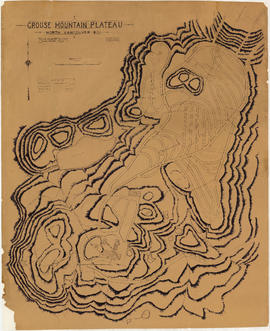
Grouse Mountain Plateau, North Vancouver, B.C.
Part of City of Vancouver Archives technical and cartographic drawing collection
Item is a topographic map showing the contours of Grouse Mountain Plateau, and various lakes, ponds, and creeks, and industrial developments including parking roads, parking areas, bridges, and scenic trails.

Guide map: Vancouver - New Westminster, Burnaby and North Shore municipalities
Part of City of Vancouver Archives technical and cartographic drawing collection
Item is a street map of Vancouver, Burnaby, New Westminster and the North Shore showing city limits and boundaries of central office areas. Map has been annotated to show the old and new Vancouver telephone exchange boundaries prior to and after the introduction of flat rate service on November 1, 1937.
Part of City of Vancouver Archives technical and cartographic drawing collection
Item is a pamphlet advertising BC Electric City routes, including observation car routes conducted by Teddy Lyons. The front side of the unfolded pamphlet includes information on City streetcar routes and interurban routes. The reverse side includes information on routes to major attractions and a map of Vancouver showing routes and attractions.
![Map of Stanley Park [site plan]](/uploads/r/null/1/c/1c9f6dc06e0884db9e77fbf60ada5f034a83d9de980993fddeb5e2475c9e2b97/52d1c868-f7bb-48bd-a2e8-0fa3444cfeec-MAP62_142.jpg)
Map of Stanley Park [site plan]
Part of City of Vancouver Archives technical and cartographic drawing collection
Item is a copy of a published map of Stanley Park which has been annotated to show proposed redevelopment plan for the western portion of Coal Harbour (currently Lost Lagoon) and surrounding area. It is believed that this is one of the sheets referred to by Thomas Mawson in his report to the Board of Parks Commissioners regarding various proposed development schemes for the entrance to Stanley Park and the Coal Harbour area.
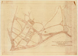
Map of Stanley Park, Vancouver, B.C.
Part of City of Vancouver Archives technical and cartographic drawing collection
Map shows roads, trails, horse trails, street railways, beaches and buildings in Stanley Park.

Map of Stanley Park, Vancouver, B.C.
Part of City of Vancouver Archives technical and cartographic drawing collection
Map of Stanley Park, verso.

Map of Stanley Park, Vancouver, B.C.
Part of City of Vancouver Archives technical and cartographic drawing collection
Map shows roads, trails, horse trails, street railways, beaches and buildings in Stanley Park. There is a drawing in pencil on verso of a circle around the letter 'K', with a description of the flowers chosen to create the arrangement, the number of flower bulbs needed, and their prices.
Map of Stanley Park, Vancouver, B.C.
Part of City of Vancouver Archives technical and cartographic drawing collection

Map of Stanley Park, Vancouver, B.C.
Part of City of Vancouver Archives technical and cartographic drawing collection
Map verso is a drawing in pencil of a circle around the letter 'K', with a hand-written description of the flowers chosen to create the arrangement, the number of flower bulbs needed, and their prices. Also shows the City of Vancouver crest and publisher information.
Map of Vancouver and Lower Mainland : avenue guide
Part of City of Vancouver Archives technical and cartographic drawing collection
Map includes Lower Mainland, B.C. and shows streets, railways, street cars, bus lines, schools, parks and industry.

Pacific National Exhibition grounds plan
Part of City of Vancouver Archives technical and cartographic drawing collection
Item is a map showing a site plan of Exhibition Park, with calculations of parking lot capacities on the Pacific National Exhibition grounds. Two areas on the map have been shaded in blue. The attached sheet lists square footages of parking lots, buildings, leases and other areas around the park.
Part of City of Vancouver Archives technical and cartographic drawing collection
Item is a diazotype copy of a site plan which shows gardens, ponds, buildings and roads for the area at the entrance of Stanley Park.
Cartwright Matheson Company (Vancouver, B.C.)

Plan showing lands occupied in Stanley Park near Brockton Point, City of Vancouver, B.C.
Part of City of Vancouver Archives technical and cartographic drawing collection
Map shows parcels of land (1-8) in Stanley Park and indicates what kind of structures are located on the land. The area for each parcel of land is given in acres.


Selected park programs for additional park sites 1959-1976
Part of City of Vancouver Archives technical and cartographic drawing collection
Item is a map showing park programs for 1959-1976. Map was most likely created by the parks department and includes a legend depicting the following information: program A (7,200,000), program B (18,000,000), program C (28,800,000), potential major park sites from which additional acreage is to be selected for each program and existing park sites. The map shows locations selected for alternative programs and locations omitted from alternative programs. Map shows street names and extends from Boundary Road to Stanley Park to University Endowment Lands to Lulu Island.

Sheet 1 : Cambie Street to Carolina Street and Sixteenth Avenue to Twenty-eighth Avenue
Part of City of Vancouver Archives technical and cartographic drawing collection
Item is a section showing the area from Cambie Street to Carolina Street and Sixteenth Avenue to Twenty-eighth Avenue. Includes streets, roads, blocks, lots, legal descriptions, parks, nurseries and schools.
Vancouver (B.C.). Office of the City Engineer

Sheet 1 : Slocan Street to Boundary Road and Triumph Street to Burrard Inlet
Part of City of Vancouver Archives technical and cartographic drawing collection
Item is a section showing the area bound by Slocan Street, Boundary Road, Triumph Street and the waterfront. Includes streets, roads, railways, blocks, lots, legal descriptions, quit claims, leases, parks and businesses along the waterfront.
Vancouver (B.C.). Office of the City Engineer

Sheet 1: Slocan Street to Boundary Road and Triumph Street to Burrard Inlet
Part of City of Vancouver Archives technical and cartographic drawing collection
Item is a section showing the area bound by Slocan Street, Boundary Road, Triumph Street and the waterfront. Includes streets, roads, railways, blocks, lots, legal descriptions, quit claims, leases, parks and businesses along the waterfront.
Vancouver (B.C.). Office of the City Engineer

Sheet 10 : Carlton Street to Boundary Road and Fortieth Avenue to Fiftieth Avenue
Part of City of Vancouver Archives technical and cartographic drawing collection
Item is a section showing the area from Carlton Street to Boundary Road and Fortieth Avenue to Fiftieth Avenue. Includes streets, roads, blocks, lots, legal descriptions, parks and schools.
Vancouver (B.C.). Office of the City Engineer

Sheet 10 : Clark Drive to Nanaimo Street and Frances Street to Burrard Inlet
Part of City of Vancouver Archives technical and cartographic drawing collection
Item is a section showing the area from Clark Drive to Nanaimo Street and Frances Street to Burrard Inlet. Includes streets, blocks, lots and legal descriptions, and the locations of parks and a juvenile detention home.
Vancouver (B.C.). Engineering Services
![[Sheet 10 : Clark Drive to Nanaimo Street and Frances Street to Burrard Inlet]](/uploads/r/null/b/1/b1095cb557ec54cc1f1894faad721045c1eaa4b11b76e6c08ec0349a9138f078/f41cbf9e-303f-40cd-8ef4-f0699363222c-MAP339_142.jpg)
[Sheet 10 : Clark Drive to Nanaimo Street and Frances Street to Burrard Inlet]
Part of City of Vancouver Archives technical and cartographic drawing collection
Item is a sectional map of a portion of Vancouver showing the area from Clark Drive to Nanaimo Street and Frances Street to Burrard Inlet. Includes streets, blocks, lots and legal descriptions, and the locations of parks and a juvenile detention home.

Sheet 10 : Clark Drive to Slocan Street and waterfront to Triumph Street
Part of City of Vancouver Archives technical and cartographic drawing collection
Item is a section showing the area from Clark Drive to Slocan Street and aterfront to Triumph Street. Includes streets and roads, blocks, lots, legal descriptions, railways, parks, boys' detention home and businesses along the waterfront. The Town of Hastings is indicated on the map.
Vancouver (B.C.). Office of the City Engineer

Sheet 10 : Clark Drive to Slocan Street and waterfront to Triumph Street
Part of City of Vancouver Archives technical and cartographic drawing collection
Item is a section showing the area from Clark Drive to Slocan Street and waterfront to Triumph Street. Includes streets and roads, blocks, lots, legal descriptions, railways, parks, boys' detention home and businesses along the waterfront. The Town of Hastings is indicated on the map.
Vancouver (B.C.). Office of the City Engineer

Sheet 11 : Cambie Street to St. George Street and Forty-seventh Avenue to Fifty-eighth Avenue
Part of City of Vancouver Archives technical and cartographic drawing collection
Item is a section showing the area from Cambie Street to St. George Street and Forty-seventh Avenue to Fifty-eighth Avenue. Includes streets, roads, blocks, lots, legal descriptions, golf courses, parks and schools.
Vancouver (B.C.). Office of the City Engineer

Sheet 11 : Carrall Street to Clark Drive and waterfront to Keefer Street
Part of City of Vancouver Archives technical and cartographic drawing collection
Item is a section showing the area from Carrall Street to Clark Drive and waterfront to Keefer Street. Includes streets and roads, blocks, lots, legal descriptions, railways, parks, schools, freight sheds, warehouses, piers and businesses along the waterfront.
Vancouver (B.C.). Office of the City Engineer

Sheet 11 : Wall Street to Rupert Street and McGill Street to Burrard Inlet
Part of City of Vancouver Archives technical and cartographic drawing collection
Item is a section showing the area from Wall Street to Rupert Street and McGill Street to Burrard Inlet. Includes streets, blocks, lots and legal descriptions, and the locations of parks, schools, and railways.
Vancouver (B.C.). Engineering Services
![[Sheet 11 : Wall Street to Rupert Street and McGill Street to Burrard Inlet]](/uploads/r/null/e/b/eb84fb8de9ca2e1644a2e39bcbaad5253c563e8716cf25114e675fb7d40365ea/0935fb81-4662-411a-bdfd-c9823c7fb82b-MAP339_142.jpg)
[Sheet 11 : Wall Street to Rupert Street and McGill Street to Burrard Inlet]
Part of City of Vancouver Archives technical and cartographic drawing collection
Item is a sectional map of a portion of Vancouver showing the area from Wall Street to Rupert Street and McGill Street to Burrard Inlet. Includes streets, blocks, lots and legal descriptions, and the locations of parks, schools, and railways.

Sheet 12 : Prince Edward Street to Bruce Street and Forty-seventh Avenue to Fifty-eighth Avenue
Part of City of Vancouver Archives technical and cartographic drawing collection
Item is a section showing the area from Prince Edward Street to Bruce Street and Forty-seventh Avenue to Fifty-eighth Avenue. Includes streets, roads, blocks, lots, legal descriptions, parks and schools.
Vancouver (B.C.). Office of the City Engineer

Sheet 12 : Ontario Street to Clark Drive and Keefer Street to Second Avenue
Part of City of Vancouver Archives technical and cartographic drawing collection
Item is a section showing the area from Ontario Street to Clark Drive and Keefer Street to Second Avenue. Includes streets, roads, blocks, lots, legal descriptions, railways, parks and schools. Includes Terminal Avenue and land used by the Great Northern Railway and the Canadian National Railway. Annotations in pencil.
Vancouver (B.C.). Office of the City Engineer

Sheet 12 : Ontario Street to Clark Drive and Keefer Street to Second Avenue
Part of City of Vancouver Archives technical and cartographic drawing collection
Item is a section showing the area from Ontario Street to Clark Drive and Keefer Street to Second Avenue. Includes streets, roads, blocks, lots, legal descriptions, railways, parks and schools. Includes Terminal Avenue and land used by the Great Northern Railway and the Canadian National Railway.
Vancouver (B.C.). Office of the City Engineer

Sheet 13 : Fleming Street to Carlton Street and Forty-seventh Avenue to Fifty-ninth Avenue
Part of City of Vancouver Archives technical and cartographic drawing collection
Item is a section showing the area from Fleming Street to Carlton Street and Forty-seventh Avenue to Fifty-ninth Avenue. Includes streets, roads, blocks, lots, legal descriptions, parks and schools.
Vancouver (B.C.). Office of the City Engineer

Sheet 13 : Ontario Street to Clark Drive and First Avenue to Sixteenth Avenue
Part of City of Vancouver Archives technical and cartographic drawing collection
Item is a section showing the area from Ontario Street to Clark Drive and First Avenue to Sixteenth Avenue. Includes streets, roads, blocks, lots, legal descriptions, railways, parks and schools. Includes B.C. Electric Railway car barns.
Vancouver (B.C.). Office of the City Engineer

Sheet 13 : Ontario Street to Clark Drive and First Avenue to Sixteenth Avenue
Part of City of Vancouver Archives technical and cartographic drawing collection
Item is a section showing the area from Ontario Street to Clark Drive and First Avenue to Sixteenth Avenue. Includes streets, roads, blocks, lots, legal descriptions, railways, parks and schools. Includes B.C. Electric Railway car barns. Annotations in pencil.
Vancouver (B.C.). Office of the City Engineer

Sheet 13 : Rupert Street to Boundary Road and Eton Street to Burrard Inlet
Part of City of Vancouver Archives technical and cartographic drawing collection
Item is a section showing the area from Rupert Street to Boundary Road and Eton Street to Burrard Inlet. Includes streets, blocks, lots and legal descriptions and schools.
Vancouver (B.C.). Engineering Services
![[Sheet 13 : Rupert Street to Gilmore Avenue and Eton Street to Burrard Inlet]](/uploads/r/null/f/0/f03aaa2671556fb722cf612a9736c0a6b919aff4af5a9dbe048dd93863af5773/30eb2a4c-b404-4552-81da-7461e4aacfaa-MAP339_142.jpg)
[Sheet 13 : Rupert Street to Gilmore Avenue and Eton Street to Burrard Inlet]
Part of City of Vancouver Archives technical and cartographic drawing collection
Item is a sectional map of a portion of Vancouver showing the area from Rupert Street to Gilmore Avenue and Eton Street to Burrard Inlet. Includes streets, blocks, lots and legal descriptions and schools.

Sheet 14 : Ash Street to St. George Street and Marine Drive to Fraser River
Part of City of Vancouver Archives technical and cartographic drawing collection
Item is a section showing the area from Ash Street to St. George Street and Marine Drive to Fraser River. Includes streets, roads, blocks, lots, legal descriptions, parks and railway lines.
Vancouver (B.C.). Office of the City Engineer