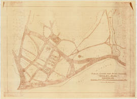
A preliminary proposal for development of Jericho Park
City of Vancouver
City of Vancouver
City of Vancouver [park sites June/80]
City of Vancouver, British Columbia
City of Vancouver, British Columbia
City of Vancouver, British Columbia : co-ordinate street index map 12
Commercial map of Greater Vancouver and district
Free map of Vancouver, New Westminster and surroundings
General development plan, Exhibition Park, Vancouver, B.C.
Grouse Mountain Park. North Vancouver, B.C.
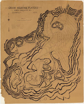
Grouse Mountain Plateau, North Vancouver, B.C.
Guide map: Vancouver - New Westminster, Burnaby and North Shore municipalities
Map of Stanley Park [site plan]
Map of Stanley Park, Vancouver, B.C.
Map of Stanley Park, Vancouver, B.C.
Map of Stanley Park, Vancouver, B.C.
Pacific National Exhibition grounds plan
Plan of grounds near bridge entrance, Stanley Park, Vancouver, B.C. : showing proposed improvements coloured red
Plan showing lands occupied in Stanley Park near Brockton Point, City of Vancouver, B.C.
Road map of Saskatchewan and Manitoba, highway map of southern Canada and the northern United States, and information on national parks in western Canada
Selected park programs for additional park sites 1959-1976
Sheet 1 : Cambie Street to Carolina Street and Sixteenth Avenue to Twenty-eighth Avenue
Sheet 1 : Slocan Street to Boundary Road and Triumph Street to Burrard Inlet
Sheet 1: Slocan Street to Boundary Road and Triumph Street to Burrard Inlet
Sheet 10 : Carlton Street to Boundary Road and Fortieth Avenue to Fiftieth Avenue
Sheet 10 : Clark Drive to Nanaimo Street and Frances Street to Burrard Inlet
[Sheet 10 : Clark Drive to Nanaimo Street and Frances Street to Burrard Inlet]
Sheet 10 : Clark Drive to Slocan Street and waterfront to Triumph Street
Sheet 10 : Clark Drive to Slocan Street and waterfront to Triumph Street
Sheet 11 : Cambie Street to St. George Street and Forty-seventh Avenue to Fifty-eighth Avenue
Sheet 11 : Carrall Street to Clark Drive and waterfront to Keefer Street
Sheet 11 : Carrall Street to Clark Drive and waterfront to Keefer Street
Sheet 11 : Wall Street to Rupert Street and McGill Street to Burrard Inlet
[Sheet 11 : Wall Street to Rupert Street and McGill Street to Burrard Inlet]
Sheet 12 : Prince Edward Street to Bruce Street and Forty-seventh Avenue to Fifty-eighth Avenue
Sheet 12 : Ontario Street to Clark Drive and Keefer Street to Second Avenue
Sheet 12 : Ontario Street to Clark Drive and Keefer Street to Second Avenue
Sheet 13 : Fleming Street to Carlton Street and Forty-seventh Avenue to Fifty-ninth Avenue
Sheet 13 : Ontario Street to Clark Drive and First Avenue to Sixteenth Avenue
Sheet 13 : Ontario Street to Clark Drive and First Avenue to Sixteenth Avenue
Sheet 13 : Rupert Street to Boundary Road and Eton Street to Burrard Inlet
[Sheet 13 : Rupert Street to Gilmore Avenue and Eton Street to Burrard Inlet]
Sheet 14 : Ash Street to St. George Street and Marine Drive to Fraser River
Sheet 14 : Cassiar Street to Boundary Road and Pender Street to Eton Street
[Sheet 14 : Cassiar Street to Carleton Avenue and Pender Street to Eton Street]
Sheet 14 : Main Street to Knight Street and Fifteenth Avenue to King Edward Street
Sheet 14 : Main Street to Knight Street and Fifteenth Avenue to King Edward Street
Sheet 15 : Ash Street to St. George Street and Fifty-eighth Avenue to Marine Drive
Sheet 15 : Oak Street to Main Street and False Creek to Sixteenth Avenue


![City of Vancouver [park sites June/80]](/uploads/r/null/9/4/9484add7c4684ea3838e4d00ee8add3ecf85d78d5aa8fe2780cae273e59556a5/bd2464d8-2aa9-4501-aba6-8b3f7d130a42-MAP1032_142.jpg)


![Map of Stanley Park [site plan]](/uploads/r/null/1/c/1c9f6dc06e0884db9e77fbf60ada5f034a83d9de980993fddeb5e2475c9e2b97/52d1c868-f7bb-48bd-a2e8-0fa3444cfeec-MAP62_142.jpg)


![[Sheet 10 : Clark Drive to Nanaimo Street and Frances Street to Burrard Inlet]](/uploads/r/null/b/1/b1095cb557ec54cc1f1894faad721045c1eaa4b11b76e6c08ec0349a9138f078/f41cbf9e-303f-40cd-8ef4-f0699363222c-MAP339_142.jpg)


![[Sheet 11 : Wall Street to Rupert Street and McGill Street to Burrard Inlet]](/uploads/r/null/e/b/eb84fb8de9ca2e1644a2e39bcbaad5253c563e8716cf25114e675fb7d40365ea/0935fb81-4662-411a-bdfd-c9823c7fb82b-MAP339_142.jpg)


![[Sheet 13 : Rupert Street to Gilmore Avenue and Eton Street to Burrard Inlet]](/uploads/r/null/f/0/f03aaa2671556fb722cf612a9736c0a6b919aff4af5a9dbe048dd93863af5773/30eb2a4c-b404-4552-81da-7461e4aacfaa-MAP339_142.jpg)


![[Sheet 14 : Cassiar Street to Carleton Avenue and Pender Street to Eton Street]](/uploads/r/null/a/4/a404347152c9328da5ec443862d19bc937a2199f1ce3cde01729819bfd1272d2/5ec2b15f-3c41-4c16-8567-f00ced74929f-MAP339_142.jpg)


