- AM1553-8-S6-: MI-321
- Item
- Aug. 29, 1991
Part of Yaletown Productions Inc. fonds
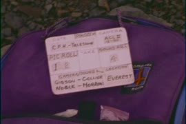
Film contains raw footage for the film "Everest - Climb for Hope." Camera: Gibson/Collier Sound: Noble/Morrow.
Part of Yaletown Productions Inc. fonds
Film contains raw footage for the film "Everest - Climb for Hope." Camera: Gibson/Collier Sound: Noble/Morrow.

Part of Yaletown Productions Inc. fonds
Film contains raw footage of people trying to get a bus unstuck from mud, and the bus passengers standing around outside the bus waiting to get going again; people hiking and carrying large packages; a small rockslide; sherpas with large packages; a goat-herder and goats; people working with technology in an ad hoc office; and monks making sculptures.
![Pender Harbour [Pender Island?]](/uploads/r/null/6/3/b/63b629a5813379cb3640aea0da51218da4a317a0931977a474787fde2fe731d4/7a952432-a23f-422d-80eb-3f21b6e3e32a-CVA440-29_142.jpg)
Pender Harbour [Pender Island?]
Group of women and children in and around an automobile
![Bus shelter [14 of 20]](/uploads/r/null/6/8/683ce00c2ef6ee8144768c14a4f6203ddfae9067da6358f94a1d41ed95d231f4/f49add76-4721-45bc-9a3b-eb2d17e56274-A64283_142.jpg)
Part of City of Vancouver fonds
Item is a photograph showing a bus stop in front of the Bower building at 543 Granville Street.
![Bus shelter [15 of 20]](/uploads/r/null/4/0/40b36833d723bfd8a96c8a3e8e6150ad07b35e81538d12d94e21e5dd318dacd4/0c2ae8d7-4872-4f4f-a0cf-25a16ff44dbe-A64284_142.jpg)
Part of City of Vancouver fonds
Item is a photograph showing a bus stop in front of the Bower building at 543 Granville Street.
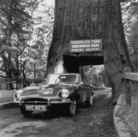
Automobile parked below the Chandelier Tree in Drive-Thru Tree Park
Part of Hamber family fonds

Part of Hamber family fonds

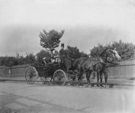
Jack Steele and the May Queen in a horse drawn carriage
Part of Hamber family fonds

Children riding in a curricle guided by a groom at Minnekhada
Part of Hamber family fonds
Photograph shows horse pulling children in a cart.

Jack Steele and the May Queen in a horse drawn carriage
Part of Hamber family fonds

Children riding in a curricle guided by a groom at Minnekhada
Part of Hamber family fonds
Photograph shows groom guiding horse pulling children in a cart.

Eric W. Hamber in horse and buggy with Aldyen at Minnekhada
Part of Hamber family fonds
Eric W. Hamber in horse and buggy at Minnekhada
Part of Hamber family fonds

Children riding in a pony cart driven by a groom at Minnekhada stables
Part of Hamber family fonds

Aldyen Hamber and Princess Alice in an automobile
Part of Hamber family fonds

Princess Alice and Aldyen Hamber
Part of Hamber family fonds

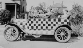
Aldyen and Eric W. Hamber in a decorated automobile
Part of Hamber family fonds

Eric W. Hamber addressing audience at the opening of the Canada Pacific Exhibition
Part of Hamber family fonds
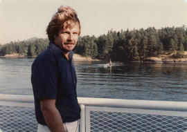
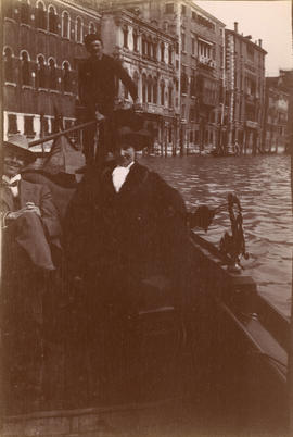
Sydney Hamber on ferry to Victoria
Part of Hamber family fonds
Part of Hamber family fonds
Cars may come and cars may go, but this one goes on forever. Amen
Part of Hamber family fonds

Part of Hamber family fonds

Part of Hamber family fonds

Part of Hamber family fonds

C.P.R. locomotive 5900 and two men
Part of Hamber family fonds

Part of Hamber family fonds

Part of Hamber family fonds
Part of Hamber family fonds

Victor and his mother G.E. Colquhoun in sailboat
Part of Hamber family fonds

Norah E. Johnson and her brother Victor Colquhoun at Riding Mountain National Park
Part of Hamber family fonds
Part of Hamber family fonds

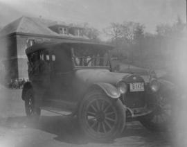
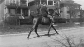
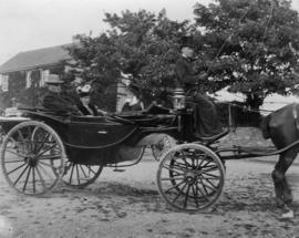
Eric W. Hamber in horse and carriage
Part of Hamber family fonds

Part of Hamber family fonds

Part of Hamber family fonds

Part of Hamber family fonds
Part of Hamber family fonds

Hendry family at Egyptian pyramids
Part of Hamber family fonds
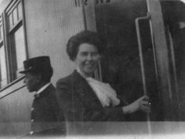
Adaline Hendry boarding a train
Part of Hamber family fonds
Part of Hamber family fonds
John and Adaline Hendry in horse drawn carriage
Part of Hamber family fonds

John and Adaline Hendry, and friends in horse drawn carriage
Part of Hamber family fonds
John and Adaline Hendry, and friends in horse drawn carriage
Part of Hamber family fonds

Part of Yaletown Productions Inc. fonds
Film produced for for the Ministry of Tourism and Small Business Development by New Horizons Films.

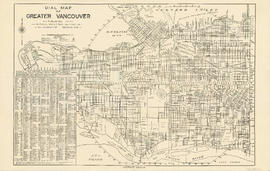
Dial map of Greater Vancouver and suburbs
Part contains a street map of Vancouver, Burnaby, New Westminster, West Vancouver and North Vancouver showing block numbers, street car, bus, and railway lines, parks and hospitals. Map includes two dials (a numbered circle, a paper indicator, a grid of block numbers and a street index used to find locations). A small inset map shows the Capitol Hill/Scenic Park area of Burnaby in greater detail.

Part contains a street map of Vancouver showing street car, bus and railway lines, hospitals, and block numbers. Part includes a dial (a numbered circle, a paper indicator, a grid of block numbers and a street index used to find locations).
Part contains a street map of Vancouver showing street car, bus and railway lines, hospitals, and block numbers. Part includes a dial (a numbered circle, a paper indicator, a grid of block numbers and a street index used to find locations).

Part of Gordon Brown fonds
Item depicts Woodward's Department Store's wagon and electric railway car on street.

Part of Bushnell family fonds