![Bus shelter [1 of 20]](/uploads/r/null/9/8/98c2987a60ec52eff5abd0e752bda92842f3549a27658c42ba1fda3e3ab8c10e/e49ee64b-0f79-4c3b-82d4-8787db1faa6a-A64105_142.jpg)
- COV-S663-: CVA 800-0114
- Item
- Jan. 1978
Part of City of Vancouver fonds
Picture shows bus shelter alongside railroad tracks.
Part of City of Vancouver fonds
Picture shows bus shelter alongside railroad tracks.
![Bus shelter [5 of 20]](/uploads/r/null/2/8/28cf6b3769210eee50b93ad4f8a454ae756a789919897bcc9ce0722994ee37b6/b65ad54e-417d-4110-8880-eda554da0f0b-A64127_142.jpg)
Part of City of Vancouver fonds
Picture shows bus shelter on street.
![Bus shelter [6 of 20]](/uploads/r/null/9/a/9a0f169f0fa99661c133a79055b71340b248e47024cb0ed9b1078c8566f2bd70/e58dd43c-028c-41fa-81d0-6a21b1374ea3-A64128_142.jpg)
Part of City of Vancouver fonds
![Bus shelter [9 of 20]](/uploads/r/null/b/f/bfb0381a2d79232f7c45923c5b5593fe7c8d3ea734efcab681fbec5b9dce5527/433a367e-3049-4d79-acc1-4b5920fe32e7-A64163_142.jpg)
Part of City of Vancouver fonds
![Miscellaneous [10 of 130]](/uploads/r/null/8/0/8049d8ca8c93c4eac9849fa9f93abca07db6cb5b431f47f3e223583d00ffec81/c29c2d1f-d482-4963-aa07-1e9767ed4301-A64298_142.jpg)
Part of City of Vancouver fonds
Buses stopped at bus shelter.
![Bus shelter [17 of 20]](/uploads/r/null/3/d/3debe17e6e2056dc834e8a7fdf4da31a9d65b761386c6e35d539a424ed2c08b9/4167f175-9f4d-4d55-a53e-6bedb917e389-A66179_142.jpg)
Part of City of Vancouver fonds
Image shows Oakridge bus shelter on west side of Cambie S. at 41st Ave.
![Pender Harbour [Pender Island?]](/uploads/r/null/6/3/b/63b629a5813379cb3640aea0da51218da4a317a0931977a474787fde2fe731d4/7a952432-a23f-422d-80eb-3f21b6e3e32a-CVA440-29_142.jpg)
Pender Harbour [Pender Island?]

Oakridge Transit Centre Open House

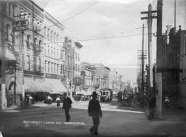
Hastings street looking east from Cambie

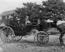
Man seated in a horse-drawn buggy under the viaduct
Part of City of Vancouver fonds

Part of City of Vancouver fonds

Item is a map showing cities and towns, smaller settlements, post offices, railways, roadways, trading posts, ferries, hospitals, telegraph lines, government agents' offices, mining and sub-mining recording offices, falls and rapids, drainage flow, and park, provincial, and international boundaries. An inset map shows the southern Vancouver Island and Lower Mainland area in greater detail. Item includes road, rail, and coastal distance tables, lists of administrative offices and their locations, and an index of post offices.

Item is a map of the Prince Rupert, British Columbia area showing lands alienated or covered by applications under the Land Act, timber leases, First Nations reserves, land district, provincial forest, and park boundaries, forest management licences, municipalities, post offices, hospitals, sub-mining recording offices, railways, roadways, airports, seaplane anchorages, elevations, telephone and power lines, and glaciers. An index map shows the area covered by the primary map in relation to the rest of British Columbia and other maps published in the series.
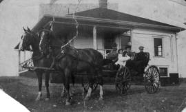
John and Adaline Hendry in horse drawn carriage
Part of Hamber family fonds
Part of Hamber family fonds

Aldyen Hamber and Princess Alice in an automobile
Part of Hamber family fonds

Children riding in a pony cart driven by a groom at Minnekhada stables
Part of Hamber family fonds

Eric W. Hamber in horse and buggy with Aldyen at Minnekhada
Part of Hamber family fonds

Children riding in a curricle guided by a groom at Minnekhada
Part of Hamber family fonds
Photograph shows horse pulling children in a cart.

Part of Hamber family fonds
Cars may come and cars may go, but this one goes on forever. Amen
Part of Hamber family fonds

Part of Hamber family fonds

Part of Hamber family fonds

Part of Hamber family fonds

City of Vancouver, British Columbia
Part of City of Vancouver Archives technical and cartographic drawing collection
Item is a map which shows city streets and blocks. The map also notes the location of parks, golf courses and transportation infrastructure.
![[Man helping a woman into a truck labeled as "McDonald Bus Line"]](/uploads/r/null/0/d/0d4d7b38fb2f34640f256a619f456109b10d1500b41beb1beac51f103e4654ee/69b12d98-2f28-4f40-a461-9615bcafc7df-A12989_142.jpg)
[Man helping a woman into a truck labeled as "McDonald Bus Line"]

Item is a map showing wards, district lots, streetcar lines, railways, and names of businesses occupying waterfront sites on False Creek and Burrard Inlet.

Bus routings in the downtown area
Part contains textual information about bus routes and services.

Part of Dunbar History Project fonds
Item filed under Transportation. Courtesy B.C. Hydro information services.

Part of Dunbar History Project fonds
Item filed under Transportation.
!["Farewell to Brill" two Brills [Brill trolley buses] westbound on 41st at Dunbar](/uploads/r/null/b/6/b64665374b5a976e4f90c2116caa5e28cf9e28585dfffd5faa9ed855070b7935/8694bcbf-2554-4cb6-83c0-2a5de6e85be7-A73259_142.jpg)
"Farewell to Brill" two Brills [Brill trolley buses] westbound on 41st at Dunbar
Part of Dunbar History Project fonds
Item filed under Transportation.
Part of Dunbar History Project fonds
Item filed under Transportation.
West 41st Avenue looking east toward West Boulevard
Part of Dunbar History Project fonds
Item filed under Transportation. An interurban streetcar is visible in the background of the image.

Audrey Gowe and her mother, Flora in front of CPR station on Dominion Day, first car, 1925
Part of Dunbar History Project fonds
Item filed under Transportation. Note that the steering wheel is on the right.

Part of Dunbar History Project fonds
Item filed under Transportation.
![Expo day 2 - cam[era] rolls 1-3](/uploads/r/null/1/2/1228966/0deaf394-aa01-4132-8a7e-7f22a0761cdc-V00205_142.jpg)
Expo day 2 - cam[era] rolls 1-3
Part of Yaletown Productions Inc. fonds
Includes raw footage taken at Expo 86; includes shots of Prince Charles and Lady Diana, Princess of Wales, with Brian Mulroney visiting Vancouver and the Expo site. Captures scenes of the Snowbirds performing for Expo crowds. An RCMP band and mounted RCMP. Silent film.

Part of Yaletown Productions Inc. fonds
Original 16mm colour negative uncut; raw film footage shot at Expo. Silent film.
![World In The City - roll [II]](/uploads/r/null/1/2/1229049/d21c9978-4c2f-436c-bd73-30df2221eb36-V00208_142.jpg)
Part of Yaletown Productions Inc. fonds
Film features the raw footage shot at Expo 86 showing the monorail, the gondolas, ships in harbour, the Expo 86 grounds and pavilions, First nations dancers, aerial views, girl with red spherical travel machine, the USA pavilion with NASA footage, the China pavilion, animals in Canada's North: walruses, polar bears, the arctic fox, a model of a city with moving traffic and working traffic lights. Silent film.

Part of Yaletown Productions Inc. fonds
Film produced for for the Ministry of Tourism and Small Business Development by New Horizons Films.

Part of Major Matthews collection

Astronaut, elevated rail, rocket ship and submarine
Item is a photographic reproduction of a graphic showing an astronaut, an elevated railcar, rocket ship and submarine.

South western British Columbia
Item is a map of southwestern British Columbia and northwestern Washington showing cities, municipalities, and settlements, post offices, government agents, railways, roads, ferry and steamship routes, air and seaplane ports, parks, campsites, glaciers, customs ports of entry, and elevations of mountains. Inset maps show the islands north of Cape Scott and the Seattle region. An small key map shows the primary map's location in relation to the rest of British Columbia and other maps published in the same series.

Preliminary map : Stikine River
Item is a map of the Stikine River region from Dease Lake in the north to Stewart in the south. Map shows land and timber surveys, government and First Nations reserves, mining division and international boundaries, government agents' offices, mining and sub-mining recording offices, post offices, villages, Hudson's Bay Company posts, telegraph lines, hospitals, schools, radio stations, triangulation stations, railways, roadways, bridges, falls and rapids, glaciers, and topographic contours.

Grassie's Carriage and Wagon Shop and General Blacksmith
Part of Grassie Jewellers fonds
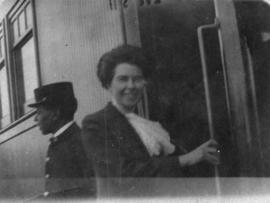
Adaline Hendry boarding a train
Part of Hamber family fonds

Hendry family at Egyptian pyramids
Part of Hamber family fonds
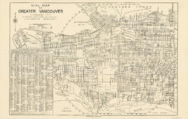
Part contains a street map of Vancouver showing street car, bus and railway lines, hospitals, and block numbers. Part includes a dial (a numbered circle, a paper indicator, a grid of block numbers and a street index used to find locations).