
- AM54-S4-: Trans P109
- Item
- [ca. 1914]
Part of Major Matthews collection
Part of Major Matthews collection
![[Street cars and taxicabs on Hastings Street]](/uploads/r/null/e/3/e3460b082958ce0fb70de47b3e1459bdb3ce0a26a86c14d8c3200e76490c633e/2bb3fbd4-de88-4667-a78d-09fa1c22a6be-A09848_142.jpg)
[Street cars and taxicabs on Hastings Street]
Part of Major Matthews collection
![Big Outfit Starting for Klondike [in front of] Johnston, Kerfoot and Company - 104 and 106 Cordov...](/uploads/r/null/b/b/bb3cd07a1ba100cc07995e16864284758450d3649cc9b80550e9281be6b626bb/f179280f-7f6a-4dfd-8bd8-ab4ea97bda41-A37249_142.jpg)
Part of Major Matthews collection
Photograph shows a mule train and the Trorey (Birks) clock
Part of Vancouver Board of Trade fonds
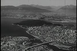
Item is an educational film documenting the history of various modes of transportation (boat, horse and carriage, plane, streetcar, train) in Vancouver from 1887 to 1962.

Yaletown Productions Inc. Highland Valley Copper - "A Temporary Use of the Land"
Part of Yaletown Productions Inc. fonds
Itemis a promotional short, titled "A Temporary Use of the Land," produced by Yaletown Productions for Highland Valley Copper (Cominco), Logan Lake, B.C.

Part of Yaletown Productions Inc. fonds
Item is a sponsored production produced by Yaletown Productions Inc for the B.C. government. "Take a Giant Step" is a 28 minute promotional documentary presented by the Government of British Colubmia on the North East Coal and Transportation Development project. Features construction and mining montauges and information about the project and the partnerships with Japan, the Federal Government of Canada and two mining companies. Produced and directed by Ken Jubenvill; executive producer Davd Brown; written by Richard Tomkies; assistant director Mike [Michael] Collier; photograph Bab Asgeirrson; edited by Mike [Michael] Collier; music composed by Bruce Ruddell; narrator Jim Hault; sound recording Ralph Parker, Rob Young, and Peter Bentley; additional photography Dave Geddes and Ron Orieux; sound re-recording Paul Sharpe; titles and animation International Rocketship. 1984.

Provincial Reports - "That's The BC Spirit"
Part of Yaletown Productions Inc. fonds
Item is a sponsored production produced by Yaletown Productions Inc. Item consists of ten, two minute, "Province Reports," with Fred Latrimouille, produced by Yaletown Productions for the government of British Columbia's "B.C. Enterprise" program. In the order that they appear on the tape they are:
-Province Report 2 "People Place/Jobs" (Oct. 5, 1982)
-Province Report 7 "Burden /Restraint" (Oct. 5, 1982)
-Province Report 9 "Teamwork/Employment Initiatives" with Grace McCarthy, Minister of Human Resources (Oct. 5, 1982)
-Province Report 10 "Getting around/Transportation" (Oct. 5, 1982)
-Province Report 11 "Future jobs/Education" (Oct. 5, 1982)| Province Report 1 "Mega projects/Jobs" (Sept. 20, 1982)
-Province Report 3 "Coalscene/Resource Mgmnt [management]" (Sept. 20, 1982)
-Province Report 4 "Transportation/Ports" (Sept. 20, 1982)
-Province Report 6 "Work share/Jobs" (Sept. 20, 1982)
-Province Report 8 "Foundations/Economic strategy" (Sept. 20, 1982)
Recording includes interview clips with various provincial politicians including Stephen Rogers, William Vander Zalm, James Hewitt, Don Phillips, Grace McCarthy and others.
![Electronic Industry promo [tional short] - "Consider the Reasons"](/uploads/r/null/1/2/1229361/598fc7d7-2382-4b52-80a9-5970ca45f928-MI-354_142.jpg)
Electronic Industry promo [tional short] - "Consider the Reasons"
Part of Yaletown Productions Inc. fonds
Item was created from the "Economic Development" (1992) 16mm, colour, raw footage (90 minutes); footage of the electronic and aerospace industry around Vancouver. From this and other footage from Yaletown Productions, two programs were edited for the Province of British Columbia, Ministry of Economic Development, Small Business and Trade. Film has a music soundtrack and has captions throughout.

Focus on Expo - one inch master - Aug. '86
Part of Yaletown Productions Inc. fonds
This item consists of video transfers of film footage shot at Expo 86. The raw footage was transferred to video and edited on tape into a finished production. According to the donor this is the original of the final production with sound and image combined. "Vancouver - Focus on Expo 86" was released August 1986 as a video postcard. Film featuring highlights of Expo 86 . Includes royal visit, highlights of USA, USSR, China, GM, Canada, BC, Folklife pavillions. Director, Michael Collier; Cinematography Bob Asgiersson; Editor Robert Brandreth-Gibbs; Writer Chris Aikenhead; Narration script Chris Aikenhead and Don White; Narrator Jim Hault; Video services Post Haste Video; Film Lab Alpha Cine Services; Sound mix Pinewood Studios; Produced by Yaletown Productions Inc. for Allstar Productions Inc.
Collier, Michael J.
Part of Yaletown Productions Inc. fonds
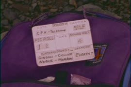
Film contains raw footage for the film "Everest - Climb for Hope." Camera: Gibson/Collier Sound: Noble/Morrow.

Part of Yaletown Productions Inc. fonds
Film contains raw footage of people trying to get a bus unstuck from mud, and the bus passengers standing around outside the bus waiting to get going again; people hiking and carrying large packages; a small rockslide; sherpas with large packages; a goat-herder and goats; people working with technology in an ad hoc office; and monks making sculptures.
The north east coal rush - progress '82
Part of Yaletown Productions Inc. fonds
Film was sponsored by the Ministry of Industry and Small Business Development, Government of British Columbia. The film shows the coal mining industry in BC. A JEM Film Production, Vancouver BC.
![Hope Merritt highway [Coquihalla]](/uploads/r/null/1/2/1229730/0f8839fb-50d7-449a-b650-4223ea7711f0-MI-282_142.jpg)
Hope Merritt highway [Coquihalla]
Part of Yaletown Productions Inc. fonds
Film was sponsored by the British Columbia provincial government and shows the construction of the Coquihalla. There is no narration; the soundtrack is all music.

Part of Yaletown Productions Inc. fonds
Film produced for for the Ministry of Tourism and Small Business Development by New Horizons Films.
!["Expo" [camera rolls 1-3]](/uploads/r/null/1/2/1228877/af3842e5-1665-4503-9fa6-663649871f85-V00211_142.jpg)
Part of Yaletown Productions Inc. fonds
Film consists of raw footage shot at Expo 86 and includes footage of RCMP officers interacting with the crowds, views of the Expo grounds from the monorail, crowds, the Roundhouse, the carousel, jugglers and mimes, demonstrations of prototype human-powered flying machines, views of the Expo grounds from the gondolas, the Expo 86 Air Plaza, the Plaza of Nations, people interacting with statues and stationary vehicles, Highway 86 a gray bridge structure with various modes of ground transport vehicles all painted a matching gray colour; people interacting and walking around the vehicles, children playing at the UFO H2O water park, and the Expo grounds. Silent film.
!["Expo" day 3 - cam[era] rolls 4-5](/uploads/r/null/1/2/1228918/3158927b-8e35-42f4-98e2-907300b7e1e5-V00210_142.jpg)
"Expo" day 3 - cam[era] rolls 4-5
Part of Yaletown Productions Inc. fonds
Film consists of raw footage taken at Expo86 and includes scenes of the Minolta Space Drop ride, food carts, crowds, the gondolas and the view from the gondola ride, people walking on the seawall, RCMP officers, the RCMP musical ride (outdoor venue, crowds seated on grass), the floating McDonalds (and the McDonalds Tidy Tug picking up floating garbage), a beer garden, music, pavilion signs, Expo 86 grounds and the outside of several national and provincial pavilions. Silent film.
!["Expo" day 3 - cam[era] rolls 1-3](/uploads/r/null/1/2/1228898/1f30da8b-9a7e-4f66-9ea6-4cc1aaf41431-V00209_142.jpg)
"Expo" day 3 - cam[era] rolls 1-3
Part of Yaletown Productions Inc. fonds
Film consists of raw footage shot at Expo 86; shows: pavilions, performers, people watching, the Canada Pavilion, the Vancouver Trade and Convention Centre, the Plaza of Nations, neon signs at the Imax theatre, cowgirls dancing, the view from a monorail car, the monorail, and crowds waiting to get on the monorail, inside the Egypt pavilion, people getting splashed riding the Cariboo Log Chute roller coaster, line-ups, crowds, people riding the Parachute Drop ride, and the view from the drop ride. Silent film.
![World In The City - roll [II]](/uploads/r/null/1/2/1229049/d21c9978-4c2f-436c-bd73-30df2221eb36-V00208_142.jpg)
Part of Yaletown Productions Inc. fonds
Film features the raw footage shot at Expo 86 showing the monorail, the gondolas, ships in harbour, the Expo 86 grounds and pavilions, First nations dancers, aerial views, girl with red spherical travel machine, the USA pavilion with NASA footage, the China pavilion, animals in Canada's North: walruses, polar bears, the arctic fox, a model of a city with moving traffic and working traffic lights. Silent film.

Part of Yaletown Productions Inc. fonds
Film consists of raw footage shot at Expo 86; includes shots of the 'China Gate,' now on Pender St. in Vancouver's Chinatown; it was gifted to the city after Expo 86 by the People's Republic of China. The film also shows various means of transportation: the gondolas, the monorail, and the skytrain; the Expo 86 grounds; including the information centre, and the BC pavilion, several other pavilions, musical performers, and a mime on a unicycle. Silent film.
![Expo day 2 - cam[era] rolls 1-3](/uploads/r/null/1/2/1228966/0deaf394-aa01-4132-8a7e-7f22a0761cdc-V00205_142.jpg)
Expo day 2 - cam[era] rolls 1-3
Part of Yaletown Productions Inc. fonds
Includes raw footage taken at Expo 86; includes shots of Prince Charles and Lady Diana, Princess of Wales, with Brian Mulroney visiting Vancouver and the Expo site. Captures scenes of the Snowbirds performing for Expo crowds. An RCMP band and mounted RCMP. Silent film.

Part of Yaletown Productions Inc. fonds
Original 16mm colour negative uncut; raw film footage shot at Expo. Silent film.
![[Vancouver history and Vancouver in the 1930s]](/uploads/r/null/1/1/1112426/1a9be229-5f41-40b2-ae6b-d9d6f7819c8d-V00101_142.jpg)
[Vancouver history and Vancouver in the 1930s]
Part of City of Vancouver Archives sound recording and moving image collection
Item is a documentary film documenting a history of Vancouver using historical photographs, maps and records as well as street scenes of Vancouver in the 1930s. The historical portions of the film contain footage about the pioneers of Vancouver including Captain George Vancouver, John Morton (first resident of what was to become the City of Vancouver), Mr. Wm. Evans (engineer on the first transcontinental train into Port Moody), Lord Granville, John Robson, Richard Earl Howe, Admiral, and Sir Harry Burrard Neale. The film also contains footage of a map of First Narrows, Burrard Inlet, English Bay and nearby Government reserves as well as a map of False Creek, the West End and the East End. In addition there is footage of Hastings Mill (1887), Gastown (1887), the heart of the city (1884), the 1886 fire, City Hall after the fire, the CPR (1887), Indian ranches on Lost Lagoon, clearings near Stanley Park, Vancouver in 1888 and 1890, the entrance to Stanley Park (1890), as well as city scenes of Vancouver in the early twentieth century.

Map and guide of Greater Vancouver
Part of City of Vancouver Archives technical and cartographic drawing collection
Item is a map and guide designed to be folded into a pocket-sized cover. Map shows streets, legal addresses, railway lines, and distances from City Hall. Text includes information on streetcar lines, train and steamship services, postal service, places of worship, office buildings, schools, and theatres.

Item is a map showing wards, district lots, streetcar lines, railways, and names of businesses occupying waterfront sites on False Creek and Burrard Inlet.

City of Vancouver, British Columbia
Part of City of Vancouver Archives technical and cartographic drawing collection
Item is a map which shows city streets and blocks. The map also notes the location of parks, golf courses and transportation infrastructure.

Preliminary map : Stikine River
Item is a map of the Stikine River region from Dease Lake in the north to Stewart in the south. Map shows land and timber surveys, government and First Nations reserves, mining division and international boundaries, government agents' offices, mining and sub-mining recording offices, post offices, villages, Hudson's Bay Company posts, telegraph lines, hospitals, schools, radio stations, triangulation stations, railways, roadways, bridges, falls and rapids, glaciers, and topographic contours.

Item is a map of the Prince Rupert, British Columbia area showing lands alienated or covered by applications under the Land Act, timber leases, First Nations reserves, land district, provincial forest, and park boundaries, forest management licences, municipalities, post offices, hospitals, sub-mining recording offices, railways, roadways, airports, seaplane anchorages, elevations, telephone and power lines, and glaciers. An index map shows the area covered by the primary map in relation to the rest of British Columbia and other maps published in the series.

Item is a map of the Terrace, British Columbia area showing lands alienated or covered by applications under the Land Act, timber leases, First Nations reserves, land district, provincial forest, and park boundaries, forest management licences, municipalities, post offices, hospitals, sub-mining recording offices, railways, roadways, airports, seaplace anchorages, elevations, telephone and power lines, and glaciers. An index map shows the area covered by the primary map in relation to the rest of British Columbia and other maps published in the series.

Item is a copy of a British Columbia Department of Lands map of British Columbia north of the 55th parallel. Map shows cities and towns, smaller settlements, post offices, railways, roadways, trading posts, ferries, hospitals, telegraph lines, government agents' offices, mining and sub-mining recording offices, hatcheries, falls and rapids, drainage flow, and park, provincial, and international boundaries. An inset map shows the far northwest area not shown on the primary map.

Item is a map showing cities and towns, smaller settlements, post offices, railways, roadways, trading posts, ferries, hospitals, telegraph lines, government agents' offices, mining and sub-mining recording offices, falls and rapids, drainage flow, and park, provincial, and international boundaries. An inset map shows the southern Vancouver Island and Lower Mainland area in greater detail. Item includes road, rail, and coastal distance tables, lists of administrative offices and their locations, and an index of post offices.

South western British Columbia
Item is a map of southwestern British Columbia and northwestern Washington showing cities, municipalities, and settlements, post offices, government agents, railways, roads, ferry and steamship routes, air and seaplane ports, parks, campsites, glaciers, customs ports of entry, and elevations of mountains. Inset maps show the islands north of Cape Scott and the Seattle region. An small key map shows the primary map's location in relation to the rest of British Columbia and other maps published in the same series.

Item is a map of the central British Columbia coast including Haida Gwaii and the mainland from Stewart in the northwest to Kleena Kleene in the southeast. Map shows cities, municipalities, and settlements, post offices, government agents, railways, roads, ferry and steamship routes, air and seaplane ports, parks, campsites, glaciers, customs ports of entry, and elevations of mountains. An small key map shows the primary map's location in relation to the rest of British Columbia and other maps published in the same series.

Northerly portion Vancouver Island
Item is a map of northern Vancouver Island and the adjacent British Columbia coast showing Crown and reserve lands, timber leases, district, park, and provincial forest boundaries, cities, municipalities, villages, post offices, hospitals, roads, railways, seaplane ports and anchorages, airports, elevations of some geographical features, and marine distances in nautical miles.

Tongass National Forest, Alaska : Copper River Meridian
Item is a map of the Tongass National Forest showing roads, trails, railways, triangulation stations, dwellings, schoolhouses, mines, landing strips, airfields, and international, national forest, and national monument boundaries. Two smaller maps show the location of the Tongass National Forest in relation to the rest of Alaska and the far northwest portion of the forest not shown on the primary map.

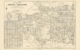
Dial map of Greater Vancouver and suburbs
Part contains a street map of Vancouver, Burnaby, New Westminster, West Vancouver and North Vancouver showing block numbers, street car, bus, and railway lines, parks and hospitals. Map includes two dials (a numbered circle, a paper indicator, a grid of block numbers and a street index used to find locations). A small inset map shows the Capitol Hill/Scenic Park area of Burnaby in greater detail.

Part contains a street map of Vancouver showing street car, bus and railway lines, hospitals, and block numbers. Part includes a dial (a numbered circle, a paper indicator, a grid of block numbers and a street index used to find locations).
Part contains a street map of Vancouver showing street car, bus and railway lines, hospitals, and block numbers. Part includes a dial (a numbered circle, a paper indicator, a grid of block numbers and a street index used to find locations).

Dial map of Greater Vancouver and suburbs
Part of City of Vancouver Archives technical and cartographic drawing collection
Part contains a street map of Vancouver, Burnaby, New Westminster, West Vancouver and North Vancouver showing block numbers, street car, bus, and railway lines, parks and hospitals. Map includes two dials (a numbered circle, a paper indicator, a grid of block numbers and a street index used to find locations). A small inset map shows the Capitol Hill/Scenic Park area of Burnaby in greater detail.

Map of Burnaby and New Westminster, British Columbia
Part of City of Vancouver Archives technical and cartographic drawing collection
Part consists of a street map of Burnaby and New Westminster, information on bus and street car routes, and text advertising the products and services of the Dominion Map and Blueprint Company.

Part of City of Vancouver Archives technical and cartographic drawing collection
Part contains a street map of Vancouver showing streets, block numbers, bus routes, railway lines, boundaries, private roads and hospitals. The map includes a dial (a numbered circle, a paper indicator, a grid of block numbers and a street index used to find locations in Vancouver). A small inset shows the streets surrounding Queen Elizabeth Park, which are obscured on the main map where the indicator is attached.

What the man who comes to Vancouver wants to know
Part of City of Vancouver Archives technical and cartographic drawing collection
Part contains information on lodging, restaurants, transit, social clubs, and other points of interest in Vancouver.

Part of City of Vancouver Archives technical and cartographic drawing collection
Part is a map showing Vancouver including Point Grey, Hastings Townsite, and part of South Vancouver. Map shows streets, street car routes, neighbourhoods, and distances from City Hall.

Street index (Gibson Street to William Street) and tram stations
Part of City of Vancouver Archives technical and cartographic drawing collection
Part is a page from the booklet accompanying a guide map of Greater Vancouver, and contains the last portion of the North Vancouver street index, the West Vancouver street index, and a list of Vancouver tram stations.

Transit detail inset maps ; Street index ; Transit and tourist information
Part consists of three maps showing transit details in Richmond, New Westminster and downtown Vancouver, and descriptive information about B.C. Electric routes and services and Greater Vancouver attractions.

Transit system map of Greater Vancouver, B.C.
Part consists of a map showing trolley coach lines, bus lines, street car lines, interurban lines, interurban stops, route numbers, B.C. Electric installations and block numbers in West Vancouver, North Vancouver, Vancouver, Burnaby and the University Endowment Lands.

Map of Fraser Valley ; Street map of New Westminster ; Map of Greater Vancouver transit lines
Part consists of a street map of the Lower Mainland and Fraser Valley from Vancouver to Chilliwack, a street map of New Westminster, a map showing transit lines in Greater Vancouver, and text advertising the products and services of the Dominion Map and Blueprint Company.

Bus routings in the downtown area
Part contains textual information about bus routes and services.

Composite map of B.C. Electric downtown bus routes
Part shows bus routes from Burrard Inlet in the north to False Creek in the south and from Main Street in the east to Thurlow in the west.