
View of 600 block East Georgia Street
- VPK-S625-: CVA 392-1198
- Item
- ca. 1960
6048 results with digital objects Show results with digital objects
View of 600 block East Georgia Street

Item is a photograph on an album page, annotated with "Bare trunks and arms are all that remain after these trees are reduced to make habitable this new apartment block 'Coniston Lodge'. The trees on the other side of this block are similarly treated."

Haro Street (corner Denman Street)
Item is a photograph on an album page, annotated with "Showing how street lighting is affected by heavy growth. NOTE: Tree planted within a foot of light pole."

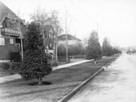
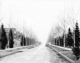
Bidwell Street (between Haro and Barclay)
Item is a photograph on an album page, annotated with "Lombardy poplars on right. Forest maples on left, always kept heavily pruned to permit of light and air to apartment block."

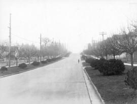
Comox Street (between Burrard and Thurlow)
Item is a photograph on an album page, annotated with "This is one of the worst examples of boulevard planting. It shows both inner and outer planting on the left side, while on the right it will be noted that the outer boulevard is planted in one section of the block and inner planting on the other section. The trees on the left (heavy forest maples) average ten to twelve feet spacing."

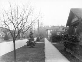
Barclay Street (between Jervis and Broughton)
Item is a photograph on an album page, annotated with "Another case of boulevarding common to the whole City and especially to the West End. Note the close planting of the heavy forest type of maple on the right, which act as a shroud to the houses fronting thereon, and the three straggling trees on the left."

Item is a photograph on an album page, annotated with "An example of conditions often met with. On the left (North side of street) the sidewalk is on the inside, with outer boulevard; on the right the sidewalk is constructed to the kerb, with inner boulevard. Proper boulevarding under such conditions is impossible. Note the forest maples planted closely together on the left and the occasional tree on the opposite side. An application is on file requesting the City to remove these trees entirely, so as to permit light and air to the houses and to make more effective street lighting at night."

Eveleigh Street (West of Burrard)
Item is a photograph on an album page, annotated with "A typical example of boulevard planting. Note the forest maple and the attempt to keep down its growth, and the other varieties of trees also 'pruned'. Left background - forest maple in full growth."
Item is a photograph on an album page, annotated with "Typical boulevarding. The permanent system carried out under the Local Improvement Scheme and maintained under Frontage Tax."

Item is a photograph on an album page, annotated with "Typical boulevarding. The permanent system carried out under the Local Improvement Scheme and maintained under Frontage Tax."

Item is a photograph on an album page, annotated with "Typical boulevarding. The permanent system carried out under the Local Improvement Scheme and maintained under Frontage Tax."
Item is a photograph on an album page, annotated with "Typical boulevarding. The permanent system carried out under the Local Improvement Scheme and maintained under Frontage Tax."
Item is a photograph on an album page, annotated with "Typical boulevarding. The permanent system carried out under the Local Improvement Scheme and maintained under Frontage Tax."
Item is a photograph on an album page, annotated with "Typical boulevarding. The permanent system carried out under the Local Improvement Scheme and maintained under Frontage Tax."
Item is a photograph on an album page, annotated with "Illustrating the pleasing effect of a properly and systematically planted boulevard."

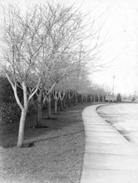
Burnaby Street (looking towards English Bay)
Item is a photograph on an album page, annotated with "One of the few sections properly and systematically boulevarded.

Item is a photograph on an album page, annotated with "This scene is common wherever the native or forest maple grows. Every year work of this nature has to be undertaken at a heavy cost. Note the size of the roots which lift the sidewalks."

Denman Street (between Nelson and Comox)
Item is a photograph on an album page, annotated with "In this block the heavy type of forest maple was planted on the inner boulevard. This is a typical instance of how the owners of the houses affected by such trees deal with them in their desire for light and air. NOTE: That in the next block is outer planting."

Robson Street (between Thurlow and Bute)
Item is a photograph on an album page, annotated with "Trees without form or beauty. Note their effect upon street lighting at night."

Thurlow Street (corner of Davie looking north)
Item is a photograph on an album page, annotated with "On the right is another example of the growth of the forest maples after heavy pruning a few years ago by the B.C.E. R[ai]l[wa]y. Co. to remove the danger from contact with their light wires. These trees have almost reached their former proportions and the danger still exists. On the left note the inner and outer planting and the large tree in the foreground, one hundred feet in height."

Haro Street (between Cardero and Bidwell)
Item is a photograph on an album page, annotated with "The pole-like looking tree is all that remains of what was once a full grown Lombardy poplar; this is how the owner of the house fronting them dealt with these specimens in order to obtain light and air and to prevent dampness, from which his house was suffering. Note the variety of other trees and their close spacing."

Melville Street (West of Burrard)
Item is a photograph on an album page, annotated with "One of the streets whose trees were heavily pruned at the expense of the B.C.E. Rly. Co., at a cost of $3,000, a few years ago, the work being necessary to remove the menace caused through the heavy growth coming in contact with light wires. NOTE: The trees have grown almost to their former size and further heavy expense is again necessary to reduce them."

Comox Street (looking East from Denman)
Item is a photograph on an album page, annotated with "A 'hit-and-miss' example of boulevard planting. Note the varieties of trees planted, size and age, and the gaps left unplanted."
![[View of 41st Avenue at Blenheim Street]](/uploads/r/null/3/2/d/32d64e2ff48ba11eff30bc7c74f38494851ac99c919ae806c80dcc02ae7ac4e8/acd2b849-e883-44bf-aa18-b03cedbd0350-CVA480-336_142.jpg)
[View of 41st Avenue at Blenheim Street]
![[View of 100 block West Cordova Street, south side, looking east]](/uploads/r/null/0/d/4/0d42b77e9d578c3c8554b3640a7d3f27a72839fab0ec6e4eb805d16de90285b8/abd54da6-9198-4386-9052-c77e37baf43d-CVA480-332_142.jpg)
[View of 100 block West Cordova Street, south side, looking east]
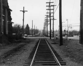
16th Avenue at Arbutus Street - Tracks looking south from north of 16th Avenue

Part of City publications collection
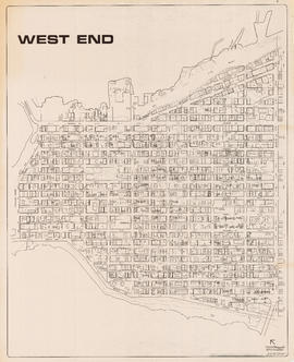
Item is a map showing streets, building footprints and number of storeys.

Part of City publications collection
Item is a map showing streets, building footprints and number of storeys.
Part of City publications collection
Item is a map showing streets, building footprints, number of storeys, topographic contour lines, and street codes according to a system adopted by the Engineering Department in the mid-1960s.

Part of City publications collection
Item is a map showing streets, building footprints, number of storeys, and street codes according to a system adopted by the Engineering Department in the mid-1960s.


Part of City publications collection

Part of City publications collection

Part of City publications collection

Part of City publications collection

Part of City publications collection

Part of City publications collection

Part of City publications collection

City of Vancouver, B.C. area map : Inverness Street to Boundary Road and 32nd Avenue to 54th Avenue
Part of City publications collection

Part of City publications collection

Part of City publications collection

City of Vancouver, B.C. area map : Maple Street to Heatley Avenue and Burrard Inlet to 6th Avenue
Part of City publications collection
City of Vancouver, B.C. area map [sectional map]
Part of City publications collection
Item is a sectional map of Vancouver showing streets, address block numbers, and street codes according to the system adopted by the Engineering Department in the mid-1960s.
The encyclopedia of Commercial Drive to 1999.
The Drive : a retail, social and political history of Commercial Drive, Vancouver, to 1956
![Water Street - #3 [5 of 5]](/uploads/r/null/9/5/95dff4c94c5d063af030a386c91c1b16a78793d305db430a9af58f5f6b9d2d1a/73382c85-af13-4100-bfa7-1be60bb38c54-A69208_142.jpg)
Part of City of Vancouver fonds
![Water Street - #3 [4 of 5]](/uploads/r/null/5/f/5f027d991858968fc57b4d0898deb1575f67cce0529b281d28afc46fcd4c68da/8df76ae9-4680-4080-aaa7-742356dc3084-A69207_142.jpg)
Part of City of Vancouver fonds
![Water Street - #3 [3 of 5]](/uploads/r/null/0/b/0ba8a40824be19897cc2f0c211a592959075f6c0799db22359b215a58a377c39/8b075081-0318-4aa7-b4ef-12cd746245f4-A69206_142.jpg)
Part of City of Vancouver fonds
![Water Street - #3 [2 of 5]](/uploads/r/null/6/1/615412d934a3773ee2a6012f8b51819425e8b42f5b96579be595c33212cd73cf/ae3882fa-0fc0-4b9d-8b69-680e77666e08-A69205_142.jpg)
Part of City of Vancouver fonds
![Water Street - #3 [1 of 5]](/uploads/r/null/a/2/a2076e1c63912f6213954d51461c25690129e566de052d7637fdddcc8059c916/615375d1-8909-45fd-868c-75fd445d51f3-A69204_142.jpg)
Part of City of Vancouver fonds