Water service map of South Vancouver : Ontario Street to Fraser Street and King Edward Avenue to 34th Avenue (33rd Avenue)
Water service map of South Vancouver : Victoria Drive to Slocan Street and 27th Avenue to 35th Avenue (34th Avenue)
Water service map of South Vancouver : Slocan Street to Rupert Street and Vanness Avenue to School Road (School Avenue)
Water service map of South Vancouver : Victoria Drive to Wales Street and 35th Avenue (34th Avenue) to 46th Avenue (45th Avenue)
Water service map of South Vancouver : Fraser Street to Sherbrooke Street and 43rd Avenue (41st Avenue) to 51st Avenue (49th Avenue)
Water service map of South Vancouver : Kerr Street to Tyne Street and 46th Avenue (45th Avenue) to 56th Avenue (54th Avenue)
Water service map of South Vancouver : Victoria Drive to Vivian Street and 56th Avenue (54th Avenue) to 67th Avenue (65th Avenue)
Water service map of South Vancouver : Kerr Street to Tyne Street and 56th Avenue (54th Avenue) to 67th Avenue (65th Avenue)
Water service map of South Vancouver : Ash Street to Ontario Street and 61st Avenue (59th Avenue) to River Avenue (Marine Drive)
Water service map of South Vancouver : Point Grey boundary to Ontario Street and River Avenue (Marine Drive S.W.) to North Arm of Fraser River
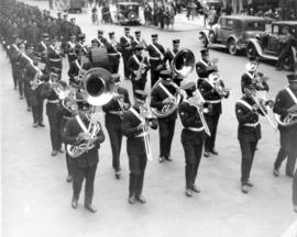
[View of Firemen's Band playing the funeral procession for Fireman Herbert E. Ellis, mortally injured on April 17, 1938]
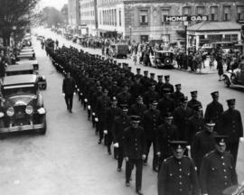
[View of funeral procession for Fireman Herbert E. Ellis, mortally injured on April 17, 1938. Funeral procession from Christ Church Cathedral with Firemen's Band]
800 Bute Street west side
800 Bute Street west side
[Burrard Street Bridge, 3 of 3]
[Area near The Buchan Hotel at 1906 Haro Street and Royal Crest Apartments at 1246 Haro Street, 2 of 12]
[Area near The Buchan Hotel at 1906 Haro Street and Royal Crest Apartments at 1246 Haro Street, 10 of 12]
[Area near The Buchan Hotel at 1906 Haro Street and Royal Crest Apartments at 1246 Haro Street, 11 of 12]
[Area near The Buchan Hotel at 1906 Haro Street and Royal Crest Apartments at 1246 Haro Street, 12 of 12]
[East Georgia Street and Princess Street intersection, 2 of 2]
[101 West Hastings Street - Woodwards Department Store]
[Cambie Street and Water Street intersection, 4 of 4]
[West Broadway intersection looking north]
[West Broadway and Macdonald Street intersection]
[West Broadway and Stephens Street intersection]
[West Broadway and Balaclava Street intersection looking north]
[Buildings at Powell Street and Jackson Avenue intersection]
[45 Dunlevy Avenue - British Columbia Maritime Employers Association]
[West Hastings Street and Granville Street intersection]
[Granville Street and West Pender Street intersection - The Toronto Dominion Bank]
[West Broadway and Balaclava Street intersection, 1 of 2]
[West Broadway and Carnarvon Street intersection]
[West Broadway and Carnarvon Street intersection]
[West Broadway and Bayswater Street intersection, 2 of 2]
[West Broadway and Macdonald Street intersection]
[West Broadway and Blenheim Street intersection, 1 of 2]


![[Burrard Street Bridge, 3 of 3]](/uploads/r/null/1/d/7/1d744db11b4d7423fbffc805972c5694e3a1fab315ac73ae3ae3f7f6205014ae/620998a7-dd5f-4266-ae95-45faccfd905f-CVA1095-15069_142.jpg)


![[East Georgia Street and Princess Street intersection, 2 of 2]](/uploads/r/null/e/e/d/eedeeebb1b1343b1c4aa4b8d85c6f80ea20fe62889895ccd4d8bc76ad4aef35a/56c8b80b-1bae-4a48-85c5-87365ebc1a79-CVA1095-15340_142.jpg)
![[101 West Hastings Street - Woodwards Department Store]](/uploads/r/null/e/8/1/e811cff88c1cc380d20b36b6f4989d780514a2b00b64263db65ff0745f31ec35/61505b36-965d-42f1-99a7-afba51b03f69-CVA1095-14283_142.jpg)
![[Cambie Street and Water Street intersection, 4 of 4]](/uploads/r/null/8/7/c/87c079d949e8658358e5375e07606ec95851044ddff36db0b58f126a30fb40c4/7108d165-ace0-4bb9-a523-c6a955bdb68b-CVA1095-14465_142.jpg)
![[West Broadway intersection looking north]](/uploads/r/null/e/4/f/e4f695dd5e6ca7a2d71293296343735503d67006ce4910f39cfda2f2c8ad90d4/6ad6e37b-f3f2-4138-898c-0ed04abc949b-CVA1095-12201_142.jpg)
![[West Broadway and Macdonald Street intersection]](/uploads/r/null/1/e/c/1ec90dd3d3120252b8d6bafdfe615de9d68546fd94aaa87e8415bfe4ffb4beae/9ab6bf18-bf79-4b3b-8ce9-f83d1a75e467-CVA1095-12265_142.jpg)
![[West Broadway and Stephens Street intersection]](/uploads/r/null/4/4/0/440f32ed3cda11bb2a5df36816881935ce8552898ad22a8446986ced3413f008/f04f9034-4911-4db7-a6e3-613a9aeb2fb6-CVA1095-12297_142.jpg)
![[West Broadway and Balaclava Street intersection looking north]](/uploads/r/null/f/0/6/f0653a99d214c1d6cf495bff8fcdce1580efae8685f8b7d83b72b440ce723174/764388e6-9714-4750-83f4-e7f04b787438-CVA1095-12347_142.jpg)
![[Buildings at Powell Street and Jackson Avenue intersection]](/uploads/r/null/9/d/f/9dffd5a7f9784dfc280f1f731eb83fbbbdb1075ab6e5afcab5cd6018b2e3ac14/40d63571-60a4-4e31-b799-915c3899daf2-CVA1095-12493_142.jpg)
![[45 Dunlevy Avenue - British Columbia Maritime Employers Association]](/uploads/r/null/0/4/8/04840eb526f6b7a0015a28e78062c4f2cecdfbaf4ff4197b2f4503989c83ac22/e80f9a3b-bc41-4d60-94f4-9e141a5deeeb-CVA1095-12546_142.jpg)
![[West Hastings Street and Granville Street intersection]](/uploads/r/null/8/1/f/81f9ab30b95b5cdf87c1ca5f75da3c87098f12398b519cb6534d60647efee61e/e87fc18b-716c-4706-9154-daaec8b21a22-CVA1095-12585_142.jpg)
![[Granville Street and West Pender Street intersection - The Toronto Dominion Bank]](/uploads/r/null/4/3/5/435ea6c1527a7ca0b41c9b75c282b23adaf17be012a73db919071d6480a2ad65/6653ad06-c557-4549-9a25-b8b6126b546b-CVA1095-12634_142.jpg)
![[West Broadway and Balaclava Street intersection, 1 of 2]](/uploads/r/null/4/2/c/42c49a375d0ee283bdf96c610de616876194d63b8d6a8f37e6a63d5788579909/951a6188-a840-415b-aa7b-ba64bfdd291d-CVA1095-11788_142.jpg)
![[West Broadway and Carnarvon Street intersection]](/uploads/r/null/0/c/5/0c5c639504a0a1c7bfc3ec43d847cc0086628f76f566ea2986ac2f9afb7c74ff/a4632201-ae09-4e12-bee9-ebf4cafbaeb6-CVA1095-11807_142.jpg)
![[West Broadway and Carnarvon Street intersection]](/uploads/r/null/0/f/4/0f455750ae494f0737fcef6688b8cf7a7ad0cb90c5700d2bad0197ea2660ca13/0cf2ad2c-880e-4a66-a2c9-6e786b7e966c-CVA1095-11826_142.jpg)
![[West Broadway and Bayswater Street intersection, 2 of 2]](/uploads/r/null/3/e/c/3ec05968d427adfe74ef02bcd25701a79334c8a8b5462aec9e9cbe804708c4a2/a4065a7f-075c-4c57-ad79-59730dadf736-CVA1095-11838_142.jpg)
![[West Broadway and Macdonald Street intersection]](/uploads/r/null/a/a/c/aacc5615f9a085725ec3d744d58a14bc63ae5b6cac6f391aa61e82bce292a717/20d4d030-3618-4955-a9ca-63290a9636f1-CVA1095-11909_142.jpg)
![[West Broadway and Blenheim Street intersection, 1 of 2]](/uploads/r/null/3/c/e/3cee158efdea25f0ee13d58527a34318c1bccd56608f21ac90be8d039cf1cf93/9f91247d-f296-4803-84ea-4aa3c1080a96-CVA1095-11922_142.jpg)
![Chinatown/West Broadway Signs [West Broadway intersection]](/uploads/r/null/7/a/3/7a34368f445e76cf9451741bb31b117257bc3f94676692078a3250ef9cbca4e6/471f5dfb-f5a8-4244-b9e5-5ca4e4e38807-CVA1095-11937_142.jpg)
![[West Broadway and Trutch Street intersection]](/uploads/r/null/7/7/9/77933142b2caf8a5d6a01255b577df5b92e95a6663c470b994ef3dad3e595cc9/e945140e-26e9-4bd1-b522-93fe9ad8470d-CVA1095-11951_142.jpg)
![[3203 West Broadway]](/uploads/r/null/7/f/7/7f71b2aa49c252b032b28182c764ee8425660a8cf4bd70014b1a98550b6b702d/3c4812ed-7dbf-409d-b447-04553736e1fc-CVA1095-11952_142.jpg)
![[West Broadway and Stephens Street intersection]](/uploads/r/null/2/a/d/2adfdb4ed7adca93a914126c162edefd7976e6b6843b582d1b1a2e1e0f8674de/43d10b87-5c9b-48ab-bb84-aabd2ec3cb96-CVA1095-11955_142.jpg)
![[West Broadway and Carnarvon Street intersection - Hagen's Travel Service]](/uploads/r/null/a/5/d/a5db22d5f6d7b17605569101601cfc42c1a5d6b5849a1d0cb3f2eb6b0a7fcbc7/7ffd40be-cacd-4a50-af85-2912b9e02b88-CVA1095-12146_142.jpg)
![[West Broadway and Balaclava Street intersection]](/uploads/r/null/3/f/7/3f7b22ca5cbffac7e2623267c3c469d1befe2c27ff6cfbab081d3bae67ec3abf/378e79ee-14f0-4544-917a-459365fd895b-CVA1095-12156_142.jpg)
![[West Broadway and Balaclava Street intersection]](/uploads/r/null/7/c/0/7c0db4f892d2130c57d32d24c1af7058fec207b79f9b2d5a02dea64a899bea9f/2e4e642d-ebf5-41d0-9a9d-e523379c9938-CVA1095-12157_142.jpg)
![[West Broadway and Macdonald intersection]](/uploads/r/null/4/c/6/4c627210799db1674e484c98d5e1ddbfc0fb2d21d573c442b2a9767b4617df41/7329661b-4344-49d5-9368-8f051e27cda6-CVA1095-12184_142.jpg)
![[West Pender Street and Richards Street intersection]](/uploads/r/null/a/b/4/ab4e7a7dd4b6a97253f63e24c56104d2a2f03eec2ab948aeba12793a34e3d888/c4ad7df6-9872-4aa9-a75c-d514f96312c1-CVA1095-12818_142.jpg)
![[200 Block Abbott Street businesses, 2 of 3]](/uploads/r/null/0/3/3/0335107a084d53e81eb3c0e0be2c24cdb35fbfa2666026d845f95e1793fec649/86620113-5c8a-4779-a542-3f65dbeb689f-CVA1095-12888_142.jpg)
![[Water Street construction, 2 of 2]](/uploads/r/null/3/8/3/38369cd1581417776b344255f48e332419761432028bb90e02b3169b11c335d4/8035bda1-7d61-4b5d-8bfa-a68295714980-CVA1095-12914_142.jpg)