Water service map of South Vancouver
Water service map of South Vancouver

Water service map of South Vancouver : Ontario Street to Fraser Street and King Edward Avenue to 34th Avenue (33rd Avenue)

Water service map of South Vancouver : Victoria Drive to Slocan Street and 27th Avenue to 35th Avenue (34th Avenue)

Water service map of South Vancouver : Slocan Street to Rupert Street and Vanness Avenue to School Road (School Avenue)

Water service map of South Vancouver : Victoria Drive to Wales Street and 35th Avenue (34th Avenue) to 46th Avenue (45th Avenue)

Water service map of South Vancouver : Fraser Street to Sherbrooke Street and 43rd Avenue (41st Avenue) to 51st Avenue (49th Avenue)

Water service map of South Vancouver : Kerr Street to Tyne Street and 46th Avenue (45th Avenue) to 56th Avenue (54th Avenue)

Water service map of South Vancouver : Victoria Drive to Vivian Street and 56th Avenue (54th Avenue) to 67th Avenue (65th Avenue)

Water service map of South Vancouver : Kerr Street to Tyne Street and 56th Avenue (54th Avenue) to 67th Avenue (65th Avenue)

Water service map of South Vancouver : Ash Street to Ontario Street and 61st Avenue (59th Avenue) to River Avenue (Marine Drive)

Water service map of South Vancouver : Point Grey boundary to Ontario Street and River Avenue (Marine Drive S.W.) to North Arm of Fraser River

Topographic map of Downtown Vancouver and the East End

City of Vancouver, British Columbia

Cambie Street between West 27th Avenue and West 33rd Avenue

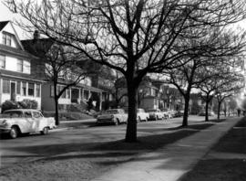
King Edward Avenue (25th)
Platanus x acerfolia 18-3 (VHTI)
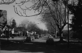
East 45th Avenue, looking west (Main to Ontario), Tulip with some Maple (?) north side

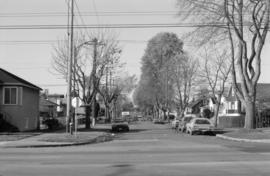
East 46th Avenue, looking west (Main to Ontario), Weeping Birch
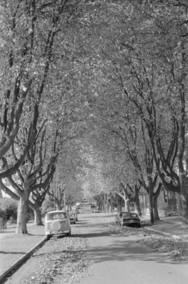
West 64th Avenue and Fremlin Street, row of London Planes, south side street

Connaught Park - 12th Avenue landscaping
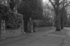
Shaughnessy Street landscaping

337 Carrall Street (revised address 1 West Hastings Street)

1000 block Nelson Street, Burrard-Thurlow, north side, view northwest

1200 block Nelson Street, Bute-Jervis, view west

1300 block Nelson Street, Jervis-Broughton, view southeast
1700 block Nelson Street, Bidwell-Denman, view east
![Streets [23 of 139]](/uploads/r/null/3/6/36e1e0e1e630053e92b8b28eab950a7490978a0651816c5057792a769d083474/d3ac16e6-ca36-4f36-8462-bc28ad54e293-A64211_142.jpg)
Streets [23 of 139]
![Streets [24 of 139]](/uploads/r/null/a/2/a20e8603a05b4c60f0a8ded650eaadd63457041b6e4732ebffce6b362e4db913/e2dea87c-5e13-4e43-8b3f-8d256f554cd4-A64212_142.jpg)
Streets [24 of 139]
![Streets [25 of 139]](/uploads/r/null/6/2/628ad76bb0e9a48752a29dc0cf40be570b965017d3cea3fcaf6fad60361e5a20/848c840c-e0bd-4a15-beca-72392fc313b5-A64213_142.jpg)
Streets [25 of 139]
![Streets [27 of 139]](/uploads/r/null/0/1/01be2ecc09f4e85b432d4870e5540be839b9abb3319eefcd8488e7d8462914bf/50f6dbcb-471b-4255-9657-0432f88dff1f-A64215_142.jpg)
Streets [27 of 139]
![Streets [40 of 139]](/uploads/r/null/5/5/5576574ffb39ca1d5abdb64e8bfd7ade1ce649387c37131b6222f3d482c09fd5/725d2710-6ccb-4f7d-b44d-7732150f1fe9-A64228_142.jpg)
Streets [40 of 139]
![Streets [87 of 139]](/uploads/r/null/2/e/2e9ee76e6daacd6d0b026366c7efcbaa0e4692e09a783a74df21b3d79a05de6e/aa226fb2-e574-4dfb-9f55-bd058120be65-A64276_142.jpg)
Streets [87 of 139]
![Streets [98 of 139]](/uploads/r/null/7/b/7bab62a4962f2f060b1c937baa39e12d82288ba4eedea72276eb302e5b9cb33c/866279da-f815-402f-b17b-79497b0898af-A64329_142.jpg)
Streets [98 of 139]
![Streets [99 of 139]](/uploads/r/null/2/e/2e709f5b8ec571dc922158d61c583609df11d655ead3de68378084389d0ee4f8/db495f74-f0e7-455b-9291-ff6e712c74c6-A64330_142.jpg)
Streets [99 of 139]
![Streets [34 of 139]](/uploads/r/null/9/7/9706fc2b24a8486559211a059a9685c27e6e2417a6118d19bb2f1b9b4e100508/3c00c869-6cf2-45a5-88a1-714dfbfefac3-A64222_142.jpg)
Streets [34 of 139]
![Streets [36 of 139]](/uploads/r/null/9/5/95112a41844b9f74a8b34c68cc0fe9ce6ec5541f97204e197cd9720cc5e47045/9d0aa579-2b86-45e2-8705-8c4814ab8b0b-A64224_142.jpg)
Streets [36 of 139]
![Streets [75 of 139]](/uploads/r/null/6/3/639f10b22123d86274ec47d707c64acb8efb3e487379e8735419fa31b081a852/ea328414-4e69-4d62-9693-848a939e85c5-A64264_142.jpg)
Streets [75 of 139]
![Streets [79 of 139]](/uploads/r/null/a/4/a4d4d55b4ed654a3227ee5c6b9444184de82d44bf9f16bef93c51dd282aa9b38/d9ff5d21-d256-40e3-97f7-b9bf1aa83c9f-A64268_142.jpg)
Streets [79 of 139]
![Miscellaneous [2 of 130]](/uploads/r/null/a/e/ae37c9a0617fd33a21bc565ace186f35b93cc4afb9bd5a034cddcbad84f96de1/c28caa78-85cd-4d91-b085-f03c08c8c4bb-A64290_142.jpg)
Miscellaneous [2 of 130]
![Miscellaneous [3 of 130]](/uploads/r/null/1/0/10cfe2996be605ef099c8b79297779128bb35a24ebd000177e44fc30ac5f88f1/0e983f50-5c26-4186-9ed9-c8758acb497b-A64291_142.jpg)
Miscellaneous [3 of 130]
![Streets [96 of 139]](/uploads/r/null/e/9/e996879785819fff9eca1f553fe3c39124ac2cf05fa4901d3860620a20e797af/13a74699-ea2d-478f-b9ae-a194bdd78aa4-A64327_142.jpg)
Streets [96 of 139]
![Miscellaneous [25 of 130]](/uploads/r/null/9/2/920494723cf29bad0c207f1bac5a68ad6bf7b962ec60e9a9eaa30bbb40976552/eda8bff7-d66d-4795-87bd-c33def564bfd-A64336_142.jpg)
Miscellaneous [25 of 130]
![Miscellaneous [26 of 130]](/uploads/r/null/6/8/68e90e3463072c72e51f2015081f8e3d991e1ba72ec02dd5a58fe8085c74348f/fd2bfb14-612f-4bff-a548-22f90666cc38-A64337_142.jpg)
Miscellaneous [26 of 130]
![Miscellaneous [30 of 130]](/uploads/r/null/7/a/7a38a2507ca731ea93c70c819ca9ff3b6635d0f8b3756aea3940526f59b56806/d7919d7d-6f5a-4b40-9c92-d99ea47a61b1-A64342_142.jpg)
Miscellaneous [30 of 130]
![Miscellaneous [40 of 130]](/uploads/r/null/4/3/438493704a352a44cef81dc662db72b9477ac890e8779f3e876218103398b5ec/fb8900d7-a919-4c3b-8b2c-53f9831ecde9-A64366_142.jpg)
Miscellaneous [40 of 130]
![Miscellaneous [45 of 130]](/uploads/r/null/6/c/6ce43982e239c2d85f5e2e391a936696b52df8f1aa4881ac67cd9c5646180a9f/795752a3-dfd7-490a-b933-9f465edf1efd-A64371_142.jpg)
Miscellaneous [45 of 130]
![Miscellaneous [66 of 130]](/uploads/r/null/f/3/f3e5c735d932ae4b6cf5264ac1126704a320ba278c9197a1e374be368226338b/a99fc078-5f61-4e29-b051-d858f0963d35-A64400_142.jpg)
Miscellaneous [66 of 130]
![Streets [111 of 139]](/uploads/r/null/7/f/7f3e94968ec381dac6958fbb9649eeda7f53f4ec23e06ba32e5df522b46e6b44/46714aec-e27e-4131-bf22-5e414eefbfef-A64402_142.jpg)
Streets [111 of 139]
![Streets [115 of 139]](/uploads/r/null/0/5/05ad6fe1eb7e6bed52357bfd702be8866a3f02398891018bf5962c8b62f182e5/3e31ee39-9368-446a-9812-29096f77a28a-A64408_142.jpg)
Streets [115 of 139]
![Streets [118 of 139]](/uploads/r/null/e/1/e17fe306535ef51abd9e9dadb827b2091cdb5b0db67b6d7194ec46ae7439eba4/4e95f1d6-aa99-42dd-a01b-c01d8a69d216-A64411_142.jpg)
Streets [118 of 139]