
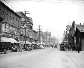
Royal Bank corner of Main and Hastings
- AM1535-: CVA 99-1392
- Item
- 1920
Part of Stuart Thomson fonds
11 results with digital objects Show results with digital objects
Royal Bank corner of Main and Hastings
Part of Stuart Thomson fonds
Part of Stuart Thomson fonds

North east corner Columbia Street and Pender Street
Part of Stuart Thomson fonds

Part of Stuart Thomson fonds

Part of City of Vancouver Archives technical and cartographic drawing collection
Item is a copy of sections of a November 1889 fire insurance map that have been pieced together. Includes the area between Seymour and Dunlevy Streets, from the south shore of the Burrard Inlet to Keefer Street. Map shows Chinatown, part of False Creek, and buildings and their uses (commercial, residential, industrial). The name of the business, business owner, or type of business is noted for most commercial and industrial buildings.
![[View of Dupont Street, later Pender Street, Chinatown area]](/uploads/r/null/6/0/606e8b9b8cb0818a46e021cda095c9662964079d95d2021f028ca4b94e14f67b/c1f3750a-82c7-4c2c-b0c6-f71c0fff69c5-A02361_142.jpg)
[View of Dupont Street, later Pender Street, Chinatown area]
Photograph shows carts, people, and a dog in the middle of the street. Various commercial buildings are also shown.
![[500 block of Carrall Street, looking north toward Pender Street]](/uploads/r/null/9/a/9a9637ab9dd6ff4452a96eae8e10ab0c3e594b6b66f64e852b56356705cbf638/f6b3daa8-b13f-4ee7-8bfd-ad0953b0e7b1-A02411_142.jpg)
[500 block of Carrall Street, looking north toward Pender Street]
Photograph shows carts, pedestrians, and buildings along the street, including the Chinese Empire Reform Association of Canada.
![[Looking north towards Pender Street along the west side of the 500 block of Carrall Street]](/uploads/r/null/9/3/93da6423bc029b02798603c4e3491c95cda7f913626589952b37f3a047ac856e/46cff22f-8189-4fae-910a-fdd17238b5e9-A02412_142.jpg)
[Looking north towards Pender Street along the west side of the 500 block of Carrall Street]
Photograph shows bicylist, carts, pedestrians, and buildings along the street.
![[A parade celebrating VJ Day on Pender Street]](/uploads/r/null/d/2/c/d2c624cbb295abd99dfcbce8c9a1d74acfe126849e3a820934416699ae942dfe/f70c97f4-1855-4fbd-9fae-db43dc0444e9-CVA260-1412_142.jpg)
[A parade celebrating VJ Day on Pender Street]
Part of James Crookall fonds
![[A parade celebrating VJ Day on Pender Street]](/uploads/r/null/6/9/5/6950ec243113934ac6ba2b533ebb6ee37a932787e8bfdc1ce53afe22fc60297d/e0189c62-fd54-4b9a-9b3b-cb2487f6373b-CVA260-1413_142.jpg)
[A parade celebrating VJ Day on Pender Street]
Part of James Crookall fonds
Photograph shows a woman holding a copy of the Vancouver Sun with the headline "Official Peace"
![[Crowds on Pender Street celebrating VJ Day]](/uploads/r/null/a/9/9/a991a667134ec81d73fd0e43cb35f65786fe7932651f4ad86a15bc18ec83b0ef/c475885b-6e4c-43eb-b7ab-4749b5006cfe-CVA260-1414_142.jpg)
[Crowds on Pender Street celebrating VJ Day]
Part of James Crookall fonds
Photograph shows James Crookall holding a copy of the Vancouver Sun with the headline "Official Peace"