New Westminster, British Columbia
- AM1594-: MAP 672
- Item
- 1861
Part of City of Vancouver Archives technical and cartographic drawing collection
Map shows the portion of New Westminster south of Columbia Street to the Fraser River. Land subdivision for the area is shown and streets are identified. Inset shows the location of New Westminster in relation to the rest of the Lower Mainland, B.C.

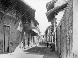
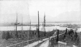
![Lytton B.C. - Frazer [Fraser] River](/uploads/r/null/1/a/1a476318c531e1a5ab3193afe22d81e9415b54f8c1a7db1e5fbc10524f9fafbe/8e4ee711-cbd1-45ea-adc6-b1cca922086b-A22920_142.jpg)


![[View of Oxford College and the University Church of St Mary the Virgin from High Street]](/uploads/r/null/f/1/f164212192dc68944a248fb5d36256a83101001766d3c9021814b461ec64b118/ba58fa64-61f2-47ae-91f8-6456bdc2544a-A19729_142.jpg)

![Cordova St[reet looking west from Carrall Street] : July 1886 - five weeks after the fire.](/uploads/r/null/d/a/da3a4547492592c411a4707bbcd6a591ecb4b4cc60db1a8ffc34127a4bc102f1/73845f2c-7ef4-4f2e-8beb-ebb16a617702-A63595_142.jpg)


![Cordova Street [looking west from Carrall Street] : July 1886 - five weeks after the fire.](/uploads/r/null/c/f/cf073fae9436b8c289be1fe62b54557d6d098b2f1db4f057c6aa56c58814a819/a0c39cee-1752-4b54-9ace-e25dade337b0-A36980_142.jpg)

![[Water Street looking east]](/uploads/r/null/a/a/aa7471c1bf02200206eb9a72517253836fa47fffd41bcf9eb126a2731d55e47a/70d184f9-4365-4cfd-b035-e7b650b8a3f4-A57251_142.jpg)


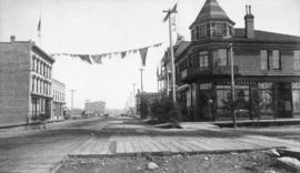
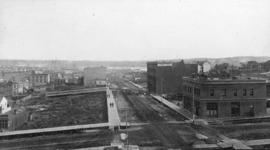
![[Northern view of Westminster Avenue (Main Street) from 7th Avenue]](/uploads/r/null/e/e/eedf5dc6b5cf6caafadff512ec18cf952b58c3fe76cbe821bad2890dd36af4ad/ead53220-dc8f-4f5e-9654-b6cea29e57c4-A43237_142.jpg)
![[Hart's Arch at] Cordova St.](/uploads/r/null/7/2/7269b3f81085862c5d10aa537ac261a5f9bddbf77402fdcc09d7e5517cea8555/e06b3981-2574-4405-8bb2-acc62c6e0063-A04852_142.jpg)
![[Cordova Street] - Inauguration of Vancouver, upon occasion of the terminus of the C. P. Railway ...](/uploads/r/null/d/4/d40dc64f82d2d3aea964d571676de3247561458b888d7d3d1060fb9ae4987203/a2f6cc92-89e2-410d-8aaf-f57ce099ae65-A01812_142.jpg)
![[Water Street looking west from Carrall Street]](/uploads/r/null/3/0/30fd42faf8356db856c52ea427b68c6239134c8c2b7e63162b2ee9018cfb76fd/ad3309ef-71c4-4b4a-94e3-a72b338accb6-A37011_142.jpg)
![[Hastings Street looking east from Seymour Street]](/uploads/r/null/5/3/535122a87a200c938c9cd8fa1e20f618f1c0e769b4c5341ce08e51b9674e5ee7/1d8217fd-2287-434e-b409-5d033b0c4f39-A37092_142.jpg)
![[Hastings Street near Seymour Street looking east]](/uploads/r/null/6/1/6165826ab604450be4dc539256af4ce87e1d4d4ef234402ea1d4eb9e14c911ad/28dff95b-22ce-468b-8fd5-b6d1895e4e72-A37094_142.jpg)

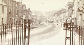
![[View of Phoenix Square, Fredericton]](/uploads/r/null/0/0/007aed5feb4fae05808d1ae651c8e9c4cc036e3527ba934b84bf21263f61a32d/988171e2-ecae-4a8b-8360-601ecb053fce-A19759_142.jpg)
![[Cordova Street looking west from Carrall Street]](/uploads/r/null/d/e/dec41fab49bb4fe8a49d2586d6e525cd0f24fbef4726e4511fcc729b9930c1ee/a266d68b-ed83-4629-811e-2f68f44748ec-A37337_142.jpg)
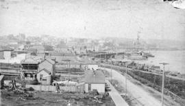
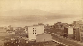
![[Unidentified American city]](/uploads/r/null/6/4/64f366831e5bf7e968fb78fecba8be78803e6835349ea3e82333d6260ce3812d/01160494-6a5c-4589-a9a0-b92eaf2cfb96-A19756_142.jpg)
![[Water Street looking east from Cordova Street]](/uploads/r/null/5/3/534a39e606ffbb6d7a4f6d0c24211f4bb4fcb8bc5eab7faaf75721c37b00a8d4/79dee9b6-b7ac-4b17-b21c-65608e24250e-A37012_142.jpg)
![Part of Cordova Street [looking east from Abbott Street] Vancouver](/uploads/r/null/a/f/af5f017adc7f7bf40db1773e103563deff369929783ec4585e5c4cdf4100179c/f39eaff7-6871-4690-883c-ee19636e93e3-A36978_142.jpg)


![[Streetcar line construction on Westminster Avenue (Main Street)]](/uploads/r/null/c/d/cd6ae92c940a945bf869cecbbd6cfc810a1c0b210fb431de7ab96c3a0f746f48/2485f482-524d-4662-b9df-0eae6874feac-A37510_142.jpg)
![[Looking northeast from Georgia Street from the Hotel Vancouver]](/uploads/r/null/8/a/8a3cf4ec45565ce8c42c5be70e3dc9bba77700670833bbf6543e337be1a6b54e/111407b8-0df6-4047-899b-7bcaf3802d1e-A43264_142.jpg)


![[Looking north from Georgia Street from the Hotel Vancouver]](/uploads/r/null/0/6/068fe03d8f45f3fc51aa86d37db6e46b2d340ec131401540ce8820b4a53f3e9a/fcf47eba-f8dc-43a3-ab61-1a71338fe9d8-A43263_142.jpg)


![[Streetcar line construction on Westminster Avenue (Main Street)]](/uploads/r/null/2/e/2e11f1b88aede4c0a2ce506bae1ec7c0a9a7fee2726e6e29c6c23f0c6b448cb1/e5f93bcf-7245-4739-999d-c179ae971e63-A37511_142.jpg)
