Topographic map of Downtown Vancouver and the East End
City of Vancouver, British Columbia
Water service map of South Vancouver : Ontario Street to Fraser Street and King Edward Avenue to 34th Avenue (33rd Avenue)
Water service map of South Vancouver : Victoria Drive to Slocan Street and 27th Avenue to 35th Avenue (34th Avenue)
Water service map of South Vancouver : Slocan Street to Rupert Street and Vanness Avenue to School Road (School Avenue)
Water service map of South Vancouver : Victoria Drive to Wales Street and 35th Avenue (34th Avenue) to 46th Avenue (45th Avenue)
Water service map of South Vancouver : Fraser Street to Sherbrooke Street and 43rd Avenue (41st Avenue) to 51st Avenue (49th Avenue)
Water service map of South Vancouver : Kerr Street to Tyne Street and 46th Avenue (45th Avenue) to 56th Avenue (54th Avenue)
Water service map of South Vancouver : Victoria Drive to Vivian Street and 56th Avenue (54th Avenue) to 67th Avenue (65th Avenue)
Water service map of South Vancouver : Kerr Street to Tyne Street and 56th Avenue (54th Avenue) to 67th Avenue (65th Avenue)
Water service map of South Vancouver : Ash Street to Ontario Street and 61st Avenue (59th Avenue) to River Avenue (Marine Drive)
Water service map of South Vancouver : Point Grey boundary to Ontario Street and River Avenue (Marine Drive S.W.) to North Arm of Fraser River
Sheet 10 : Clark Drive to Slocan Street and Burrard Inlet to Triumph Street
Sheet 8 : McLean Drive to Slocan Street and William Street to Seventh Avenue
Sheet 16 : Maple Street to Oak Street and False Creek to Sixteenth Avenue
Sheet 18 : Trutch Street to Maple Street and English Bay to Third Avenue
Sheet 21 : Burrard Street to False Creek and waterfront to Robson Street
Sheet 6 : Knight Street to Slocan Street and Eighteenth Avenue to Twenty-ninth Avenue
Sheet D : Imperial Street to Trutch Street and Fourth Avenue to Sixteenth Avenue
Sheet G : Trafalgar Street to Granville Street and Sixteenth Avenue to Nanton Avenue
Sheet X : Marine Drive to Ash Street and Fifty-ninth Avenue to Seventy-first Avenue
Sheet 6 : Craddock Street to Boundary Road and Twenty-ninth Avenue to Fortieth Avenue
Sheet 3 : Cambie Street to St. George Street and Twenty-seventh Avenue to Thirty-eighth Avenue
Sheet 13 : Fleming Street to Carlton Street and Forty-seventh Avenue to Fifty-ninth Avenue
Sheet 11 : Cambie Street to St. George Street and Forty-seventh Avenue to Fifty-eighth Avenue
Sheet 9 : Fleming Street to Carlton Street and Thirty-seventh Avenue to Forty-eighth Avenue
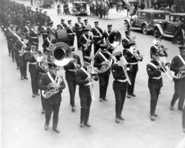
[View of Firemen's Band playing the funeral procession for Fireman Herbert E. Ellis, mortally injured on April 17, 1938]
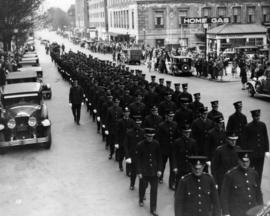
[View of funeral procession for Fireman Herbert E. Ellis, mortally injured on April 17, 1938. Funeral procession from Christ Church Cathedral with Firemen's Band]
800 Bute Street west side
800 Bute Street west side
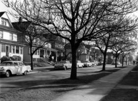
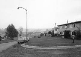
[Street in Kitsilano]
[Apartment building on the southside of the 400 block between Jackson and Dunlevy Avenues in Strathcona]
Ferry Row
[East facing cityscape view of] Water St[reet and West Cordova Street]
1000 block Nelson Street, Burrard-Thurlow, north side, view northwest
1200 block Nelson Street, Bute-Jervis, view west
1300 block Nelson Street, Jervis-Broughton, view southeast
1700 block Nelson Street, Bidwell-Denman, view east
Cambie and 12th [Avenue] taken looking south west from the City Hall
[Granville Street at Robson Street, looking south]
[Granville Street at Broadway, looking south]
[Granville Street at 11th Ave, looking south]
[One way traffic Seymour St. at Georgia Street, looking south]


![[Street in Kitsilano]](/uploads/r/null/9/9/995b64e959c5d0a2bd16b4ad59feda2f735201ac7a9d2440b83b0ff59c9015f7/26acbbfe-74dd-4783-b448-a76b1f679dc7-A58952_142.jpg)


![[East facing cityscape view of] Water St[reet and West Cordova Street]](/uploads/r/null/4/c/4ce1044a578de08f6b0c6694f11dab01ef1134bd26eacefa6b31b9eccd465ead/e75dbf34-7999-40e0-be07-94dd0603fa79-A59644_142.jpg)


![Cambie and 12th [Avenue] taken looking south west from the City Hall](/uploads/r/null/a/9/a95f8048b04d26c3060361b361c2b136bb58d850bbddd32cf9f2dc465086b275/92b1e557-98de-4bde-b1e7-944c3db510dd-A43707_142.jpg)
![[Granville Street at Robson Street, looking south]](/uploads/r/null/a/a/aa31b4fb329fc0a45fc4bf57eb1ba9577b8974130b3833b770e5a34f423e5bb2/67f9af08-68f0-415e-95e6-beed8a502406-A43709_142.jpg)
![[Granville Street at Broadway, looking south]](/uploads/r/null/a/d/ad9fb3d4863318eb2af9936be53f2590f9885be4f79a66193f9ccc3f857a8c94/ad4447d5-b4e3-4378-a692-86d3e86a5a5f-A43711_142.jpg)
![[Granville Street at 11th Ave, looking south]](/uploads/r/null/b/0/b0b95d9b06cf45c97e2a41efb25abec88233f2d3fd8a49a08c95b8769c61bde4/7c7f2be8-6b05-439e-b609-a6224798fc49-A43713_142.jpg)
![[One way traffic Seymour St. at Georgia Street, looking south]](/uploads/r/null/6/a/6ab5722dd80ce8659c50534737b97713ef7378106e8777583f6504275d6eb353/28fb7cc1-f428-4efb-9354-3631dfad7020-A43714_142.jpg)
![[Seymour St. at Nelson St., looking east]](/uploads/r/null/6/7/674f17e26621bf88a01685886f3b90e9c81d8d4f7631a2430e620005b18466ff/7df56426-d3dd-4bfd-a460-566da7150ef1-A43720_142.jpg)
![[800 E Hastings St]](/uploads/r/null/2/8/28ac1de86a0ec4e02f2ccaebd198f03b30e9d50715bfcf7843b57a82d6981417/14007932-5aa0-49f6-9caa-c7bb2c95c70a-A43722_142.jpg)
![[Hawkes Avenue at Hastings Street]](/uploads/r/null/4/3/4396259b55799a72f95a40de0cb3e84ce61fee05f34f430850ea64b1ae69c11b/d53216db-d489-4a3a-862e-f06decea401a-A43724_142.jpg)

![Macdonald [Street] and Broadway [traffic controller, 1 of 2]](/uploads/r/null/3/a/1/3a12754a1e39f675bb482fbacd2a359b53c14b5b3d8f083726bacbe30a5228b0/37e1edc3-76f5-491e-9237-453237f57d53-2019-103.0411_142.jpg)