
- AM54-S4-1-A-6-: A-6-163
- Item
- [186-?]
Part of Major Matthews collection
6048 results with digital objects Show results with digital objects
Part of Major Matthews collection
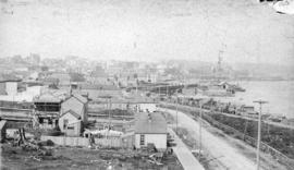
![Lytton B.C. - Frazer [Fraser] River](/uploads/r/null/1/a/1a476318c531e1a5ab3193afe22d81e9415b54f8c1a7db1e5fbc10524f9fafbe/8e4ee711-cbd1-45ea-adc6-b1cca922086b-A22920_142.jpg)
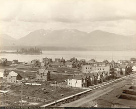
Lytton B.C. - Frazer [Fraser] River
Part of Major Matthews collection
Photograph shows the main street and businesses.

Part of Major Matthews collection

Part of Major Matthews collection
Photograph shows the main street and buildings.
New Westminster, British Columbia
Part of City of Vancouver Archives technical and cartographic drawing collection
Map shows the portion of New Westminster south of Columbia Street to the Fraser River. Land subdivision for the area is shown and streets are identified. Inset shows the location of New Westminster in relation to the rest of the Lower Mainland, B.C.
Part of Major Matthews collection
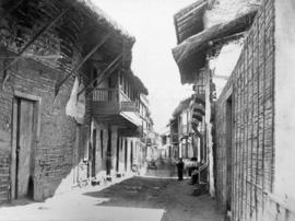
![[View of Oxford College and the University Church of St Mary the Virgin from High Street]](/uploads/r/null/f/1/f164212192dc68944a248fb5d36256a83101001766d3c9021814b461ec64b118/ba58fa64-61f2-47ae-91f8-6456bdc2544a-A19729_142.jpg)
[View of Oxford College and the University Church of St Mary the Virgin from High Street]
Part of Major Matthews collection

(Main St.) West Westminster Avenue, Vancouver
Photograph shows incomplete plank roads, a brick building in the foreground, and various other buildings in the background.
Part of Major Matthews collection

Part of City of Vancouver Archives technical and cartographic drawing collection
Map shows Hastings Town-site, Granville Town-site, Burnaby, and the City of New Westminster. Map also shows the Road from Granville and the False Creek Trail, as well as the names of places and soil types found along these roads. Other places and structures noted include Burrard Inlet, Coal Harbour (Coal Harbor on map), False Creek, False Creek Bridge, Burnaby Lake, Fraser River, New Westminster and Burrard Inlet Road, Douglas Road, Edinburgh Street, Columbia Street, Richards Street, and the New Westminster Cemetery. Two notes on map read "Plan to accompany Report of 1st May 1883, Joseph Hunter" and "Memo: Mr. Ross will place [?] this map to the [Engs.] Office Victoria [?]." 14T3 Roads & Trails is printed on the side of the map.
![Cordova St[reet looking west from Carrall Street] : July 1886 - five weeks after the fire.](/uploads/r/null/d/a/da3a4547492592c411a4707bbcd6a591ecb4b4cc60db1a8ffc34127a4bc102f1/73845f2c-7ef4-4f2e-8beb-ebb16a617702-A63595_142.jpg)
Cordova St[reet looking west from Carrall Street] : July 1886 - five weeks after the fire.
Part of Major Matthews collection
Photograph shows businesses being rebuilt after the great fire. Some businesses in the photograph are: Burrard Hotel, Tom Dunn Hardware, Grant & Arkell, Dietz (sp?) Winch, Daily News (on Hastings Street), Sekl's Furniture Store, Dougall House, Tom McDonald (on Pender Street), Mathison the Printer (on Hastings Street), Cosmopolitan Hotel, Mizony's Restaurant, F.W. Hart Furniture, Tilley's (sp?) Book Store and the Telephone Exchange.

Part of A.W. Phair fonds

Cummin's store with woman and dog
Part of A.W. Phair fonds

Part of Major Matthews collection
Photograph shows a view looking east from Richards Street toward the intersection of Water Street and Cordova Street, plank roads, buildings including the Greyhound Hotel under construction and Princess Louise Tree
![Cordova Street [looking west from Carrall Street] : July 1886 - five weeks after the fire.](/uploads/r/null/c/f/cf073fae9436b8c289be1fe62b54557d6d098b2f1db4f057c6aa56c58814a819/a0c39cee-1752-4b54-9ace-e25dade337b0-A36980_142.jpg)
Cordova Street [looking west from Carrall Street] : July 1886 - five weeks after the fire.
Part of Major Matthews collection
Photograph shows businesses being rebuilt after the great fire. The names of the businesses are written in pen across the centre of the photograph with a line indicating the building or business. Businesses identified are: Burrard Hotel, Tom Dunn Hardware, Grant & Arkell, Dietz (sp?) Winch, Daily News (on Hastings Street), Sekl's Furniture Store, Dougall House, Tom McDonald (on Pender Street), Mathison the Printer (on Hastings Street), Cosmopolitan Hotel, Mizony's Restaurant, F.W. Hart Furniture, Tilley's (sp?) Book Store and the Telephone Exchange.

Item is a photographic reproduction of a photograph showing Carrall Street in 1886. The photograph also exists under the identifier Str P83 in the COV Archives holdings.

Cummin's store with horse drawn covered wagon
Part of A.W. Phair fonds

Cummin's store with horse drawn covered wagon
Part of A.W. Phair fonds
![[Water Street looking east]](/uploads/r/null/a/a/aa7471c1bf02200206eb9a72517253836fa47fffd41bcf9eb126a2731d55e47a/70d184f9-4365-4cfd-b035-e7b650b8a3f4-A57251_142.jpg)
Part of Major Matthews collection
Photograph shows the residences of Isaac John and Ainsley Moaut and other buildings prior to the Great Fire

Topographic map of Downtown Vancouver and the East End
Part of City of Vancouver fonds
Item is a map showing two sets of topographic contour lines, streets, and block numbers (in Roman numerals) in the area from Robson Street to Raymur Avenue and Coal Harbour/Vancouver Harbour to False Creek.
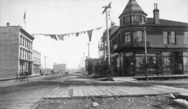
![[Cordova Street] - Inauguration of Vancouver, upon occasion of the terminus of the C. P. Railway ...](/uploads/r/null/d/4/d40dc64f82d2d3aea964d571676de3247561458b888d7d3d1060fb9ae4987203/a2f6cc92-89e2-410d-8aaf-f57ce099ae65-A01812_142.jpg)
Photograph shows arch and banners along Cordova Street, as well as flags and other decorations.
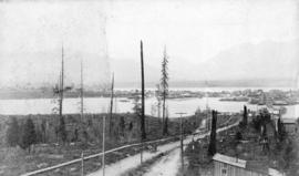
![[Northern view of Westminster Avenue (Main Street) from 7th Avenue]](/uploads/r/null/e/e/eedf5dc6b5cf6caafadff512ec18cf952b58c3fe76cbe821bad2890dd36af4ad/ead53220-dc8f-4f5e-9654-b6cea29e57c4-A43237_142.jpg)
[Northern view of Westminster Avenue (Main Street) from 7th Avenue]
Part of Major Matthews collection
Photograph shows the Westminster Avenue Trestle Bridge and False Creek in the background
![[Hart's Arch at] Cordova St.](/uploads/r/null/7/2/7269b3f81085862c5d10aa537ac261a5f9bddbf77402fdcc09d7e5517cea8555/e06b3981-2574-4405-8bb2-acc62c6e0063-A04852_142.jpg)
Part of Major Matthews collection
Photograph shows arch, flags and other decorations for the completion of the C.P.R. line to Vancouver. J.S. Matthews' notes with print or negative in Archives.
![[Water Street looking west from Carrall Street]](/uploads/r/null/3/0/30fd42faf8356db856c52ea427b68c6239134c8c2b7e63162b2ee9018cfb76fd/ad3309ef-71c4-4b4a-94e3-a72b338accb6-A37011_142.jpg)
[Water Street looking west from Carrall Street]
Part of Major Matthews collection
Photograph shows the Granville Hotel and other buildings
![[Hastings Street looking east from Seymour Street]](/uploads/r/null/5/3/535122a87a200c938c9cd8fa1e20f618f1c0e769b4c5341ce08e51b9674e5ee7/1d8217fd-2287-434e-b409-5d033b0c4f39-A37092_142.jpg)
[Hastings Street looking east from Seymour Street]
Part of Major Matthews collection
Photograph shows the Bank of Montreal and Bank of B.C. building
![[Hastings Street near Seymour Street looking east]](/uploads/r/null/6/1/6165826ab604450be4dc539256af4ce87e1d4d4ef234402ea1d4eb9e14c911ad/28dff95b-22ce-468b-8fd5-b6d1895e4e72-A37094_142.jpg)
[Hastings Street near Seymour Street looking east]
Part of Major Matthews collection
Photograph shows the residences of F.C. Innes and Dr. J.M. Lefevre, H.A. Mellon's Real Estate office and Hastings Mill in the background
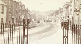
![[View of Phoenix Square, Fredericton]](/uploads/r/null/0/0/007aed5feb4fae05808d1ae651c8e9c4cc036e3527ba934b84bf21263f61a32d/988171e2-ecae-4a8b-8360-601ecb053fce-A19759_142.jpg)
[View of Phoenix Square, Fredericton]
Part of Major Matthews collection
![[Cordova Street looking west from Carrall Street]](/uploads/r/null/d/e/dec41fab49bb4fe8a49d2586d6e525cd0f24fbef4726e4511fcc729b9930c1ee/a266d68b-ed83-4629-811e-2f68f44748ec-A37337_142.jpg)
[Cordova Street looking west from Carrall Street]
Part of Major Matthews collection
Photograph shows a planked road

Part of Major Matthews collection
Photograph shows a view from Oppenheimer (Cordova) Street near Gore Avenue
![[Water Street looking east from Cordova Street]](/uploads/r/null/5/3/534a39e606ffbb6d7a4f6d0c24211f4bb4fcb8bc5eab7faaf75721c37b00a8d4/79dee9b6-b7ac-4b17-b21c-65608e24250e-A37012_142.jpg)
[Water Street looking east from Cordova Street]
Part of Major Matthews collection
Photograph shows a planked road, The Greyhound Hotel and other commercial buildings and power poles with no wiring
![[Unidentified American city]](/uploads/r/null/6/4/64f366831e5bf7e968fb78fecba8be78803e6835349ea3e82333d6260ce3812d/01160494-6a5c-4589-a9a0-b92eaf2cfb96-A19756_142.jpg)
Part of Major Matthews collection
Part of Major Matthews collection
Photograph shows a view looking west along Alexander Street
Part of Hastings Street, Vancouver
Part of Major Matthews collection
Photograph shows Hastings Street looking east from Granville Street and the Alfred Bunker and Customs House building (formerly L.A. Hamilton's house)
![Part of Cordova Street [looking east from Abbott Street] Vancouver](/uploads/r/null/a/f/af5f017adc7f7bf40db1773e103563deff369929783ec4585e5c4cdf4100179c/f39eaff7-6871-4690-883c-ee19636e93e3-A36978_142.jpg)
Part of Cordova Street [looking east from Abbott Street] Vancouver
Part of Major Matthews collection
Photograph shows Dougall House and other buildings

Part of Cordova Street, Vancouver
Part of Major Matthews collection
Photograph shows the White Swan Hotel and other buildings
Part of Vancouver, B.C. from Lealand House
Part of Major Matthews collection
Photograph shows an unpaved Hastings Street looking east from Seymour Street including the Bank of Montreal and Bank of British Columbia building and the Ferguson Block

Columbia Street in 1888 New Westminster
Part of Major Matthews collection
![[Streetcar line construction on Westminster Avenue (Main Street)]](/uploads/r/null/c/d/cd6ae92c940a945bf869cecbbd6cfc810a1c0b210fb431de7ab96c3a0f746f48/2485f482-524d-4662-b9df-0eae6874feac-A37510_142.jpg)
[Streetcar line construction on Westminster Avenue (Main Street)]
Part of Major Matthews collection
Photograph shows a view looking north from near Prior Street
![[Looking northeast from Georgia Street from the Hotel Vancouver]](/uploads/r/null/8/a/8a3cf4ec45565ce8c42c5be70e3dc9bba77700670833bbf6543e337be1a6b54e/111407b8-0df6-4047-899b-7bcaf3802d1e-A43264_142.jpg)
[Looking northeast from Georgia Street from the Hotel Vancouver]
Part of Major Matthews collection
Photograph shows the east side of the 600 Block of Granville Street and beyond including the New York Block, the Simpson Block, the Crew Block, Homer Street Methodist Church, St. Anne's Academy and Holy Rosary Church (before the steeple was built)

Part of Major Matthews collection
Photograph shows Phair's store, Allen's Hotel, Cummings Bros. Photo Gallery and other buildings

Part of Major Matthews collection
Photograph shows a view looking north from the corner of Westminster Avenue (Main Street) and 7th Avenue including the Westminster Avenue Trestle Bridge and False Creek in the background

Vancouver, B.C. from Hotel Vancouver
Part of Major Matthews collection
Photograph shows a view looking east from Georgia Street towards the 600 Block Seymour Street
Looking Across the Inlet from Hotel Vancouver
Photograph shows a view looking north from Georgia Street showing the west side of the 600 Block Howe Street including Manor House and beyond to Deadman's Island

Part of Major Matthews collection
Photograph shows a view loking north from the corner of Westminster Avenue (Main Street) and 7th Avenue including the Westminster Avenue Trestle Bridge and False Creek in the background
![[View of Vancouver from Mount Pleasant; woman standing on bridge in Stanley Park; C.P.R. wharf]](/uploads/r/null/e/1/e1c85c783bb0ce41e854ac0cd90ff28454b6aad113c9978149334788b806ff27/f448bfac-13b8-4997-bcec-d8a408ad77ad-A04390_142.jpg)
[View of Vancouver from Mount Pleasant; woman standing on bridge in Stanley Park; C.P.R. wharf]
Part of Major Matthews collection
Photograph negative is a copy of three separate photograph prints. J.S. Matthews' notes with print or negative in Archives.

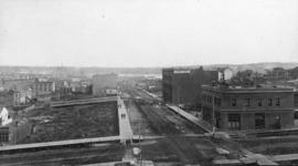
Vancouver From Westminster Avenue South
Part of Major Matthews collection
Photograph shows Main Street near 6th Avenue looking north
![[Looking north from Georgia Street from the Hotel Vancouver]](/uploads/r/null/0/6/068fe03d8f45f3fc51aa86d37db6e46b2d340ec131401540ce8820b4a53f3e9a/fcf47eba-f8dc-43a3-ab61-1a71338fe9d8-A43263_142.jpg)
[Looking north from Georgia Street from the Hotel Vancouver]
Part of Major Matthews collection
Photograph shows the 500 and 600 Blocks of between Howe Street and Granville Street including part of the C.P.R. Park, the Japanese Consul, Manor House under construction, the Van Horne Block and the Bluff showing the homes of A.G. Ferguson and Harry Abbott in the background

Part of City of Vancouver Archives technical and cartographic drawing collection
Item is a copy of sections of a November 1889 fire insurance map that have been pieced together. Includes the area between Seymour and Dunlevy Streets, from the south shore of the Burrard Inlet to Keefer Street. Map shows Chinatown, part of False Creek, and buildings and their uses (commercial, residential, industrial). The name of the business, business owner, or type of business is noted for most commercial and industrial buildings.
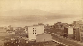
Vancouver, B.C. from the South
Part of Major Matthews collection
Photograph shows a view looking north from the corner of Westminster Avenue (Main Street) and 7th Avenue including the Westminster Avenue Trestle Bridge and False Creek in the background
Looking across the Inlet from Hotel Vancouver
Part of Major Matthews collection
Photograph shows Granville Street looking north