
- AM1594-: MAP 654
- Item
- 1889
Part of City of Vancouver Archives technical and cartographic drawing collection
Item is a copy of sections of a November 1889 fire insurance map that have been pieced together. Includes the area between Seymour and Dunlevy Streets, from the south shore of the Burrard Inlet to Keefer Street. Map shows Chinatown, part of False Creek, and buildings and their uses (commercial, residential, industrial). The name of the business, business owner, or type of business is noted for most commercial and industrial buildings.
![[View of Dupont Street, later Pender Street, Chinatown area]](/uploads/r/null/6/0/606e8b9b8cb0818a46e021cda095c9662964079d95d2021f028ca4b94e14f67b/c1f3750a-82c7-4c2c-b0c6-f71c0fff69c5-A02361_142.jpg)
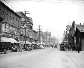
![[500 block of Carrall Street, looking north toward Pender Street]](/uploads/r/null/9/a/9a9637ab9dd6ff4452a96eae8e10ab0c3e594b6b66f64e852b56356705cbf638/f6b3daa8-b13f-4ee7-8bfd-ad0953b0e7b1-A02411_142.jpg)
![[Looking north towards Pender Street along the west side of the 500 block of Carrall Street]](/uploads/r/null/9/3/93da6423bc029b02798603c4e3491c95cda7f913626589952b37f3a047ac856e/46cff22f-8189-4fae-910a-fdd17238b5e9-A02412_142.jpg)


![[A parade celebrating VJ Day on Pender Street]](/uploads/r/null/d/2/c/d2c624cbb295abd99dfcbce8c9a1d74acfe126849e3a820934416699ae942dfe/f70c97f4-1855-4fbd-9fae-db43dc0444e9-CVA260-1412_142.jpg)
![[A parade celebrating VJ Day on Pender Street]](/uploads/r/null/6/9/5/6950ec243113934ac6ba2b533ebb6ee37a932787e8bfdc1ce53afe22fc60297d/e0189c62-fd54-4b9a-9b3b-cb2487f6373b-CVA260-1413_142.jpg)
![[Crowds on Pender Street celebrating VJ Day]](/uploads/r/null/a/9/9/a991a667134ec81d73fd0e43cb35f65786fe7932651f4ad86a15bc18ec83b0ef/c475885b-6e4c-43eb-b7ab-4749b5006cfe-CVA260-1414_142.jpg)
![[Hastings Street West and Cambie Street intersection, 1 of 2]](/uploads/r/null/c/1/5/c157dc711a3e1cdf718061d68df4d7a6f776425abdcbfb59f3e8e7fa4d54e3e9/ccd0166b-6d81-4ac9-a2d7-4c2f21533b05-CVA1095-09750_142.jpg)
![Historic Area, Hastings Street [Alleyway]](/uploads/r/null/3/1/4/3146c411deee6f791a95f2277d09b6210959ab24f6c5cbe38edcec9d14ded175/d2df2e34-9bb7-45b8-ad58-a719ee0d5a77-CVA1095-09754_142.jpg)
![[Hastings Street West and Cambie Street intersection, 2 of 2]](/uploads/r/null/5/9/7/59739f417d7ff0c0a8afbeb3769b9281aa2f25bbc86c04bd880e6657094a37e8/7804d1a9-7c49-4b21-bdd1-91fe0d3e8567-CVA1095-09751_142.jpg)
![Historic Area, Hastings Street [Alleyway]](/uploads/r/null/9/0/8/908f4d00be95def90fd518388252c5da061371d4f4e97dd1f98f1aa5f1f5453d/fbb2750b-1ba3-40ac-a9b0-e9a593357b23-CVA1095-09753_142.jpg)
![Chinatown, East Hastings, Blood Alley [Alley]](/uploads/r/null/6/5/d/65dba85f30c5f5a1e6986edfd88c6dfb7f89570e32bd339cc8cd6dc696360006/3dfc5f18-bca5-41dd-b75e-0be0aa0d04ff-CVA1095-08761_142.jpg)
![[Parking lot behind Army and Navy]](/uploads/r/null/1/0/c/10c9e25dac0a43d12d5da8a5dbdb35ee50de8318ac9acd44f0f99e3e86b50273/97ec988f-a41e-44ef-9d6c-0dbede8a3525-CVA1095-08762_142.jpg)
![Chinatown, East Hastings, Blood Alley [Alley]](/uploads/r/null/b/c/c/bcce146b66db06eb0f5dd5b642071b6351db2f3df1620a2c999c6ace609a57ef/07cfae8d-1492-45eb-8c5f-a86b2a958abc-CVA1095-08765_142.jpg)
![Chinatown, East Hastings, Blood Alley [Walk sign]](/uploads/r/null/8/d/0/8d059c43cb52f570064fb2abc7b723160ce3a8d764559c7a656d13bccf892988/d8b4e4df-76bd-4a0f-bf2e-ebc665b3725c-CVA1095-08778_142.jpg)
![Chinatown, East Hastings, Blood Alley [Phone booth]](/uploads/r/null/0/6/a/06a43152fc5ef1365ec9f615f2370039f33a0f1f8e4d9fad5c0b53818819a94c/fdcd668b-96c5-4ea7-a422-ca6b2e26b779-CVA1095-08781_142.jpg)
![Chinatown, East Hastings, Blood Alley [Base of pole]](/uploads/r/null/e/3/b/e3bd5de8aa2204b57e4b3bba6647bab5e08283c833c5bbb31f4a6e8104eaa208/fd08d8cb-692c-4dd7-89b5-33dd291a0886-CVA1095-08782_142.jpg)
![Chinatown, East Hastings, Blood Alley [Walk sign]](/uploads/r/null/2/d/1/2d1760cb1adf89cb2c06a7f5253eb157b681b3ea8f7723cc1eab9829c120652d/64943228-8899-49cd-ae51-0fba1d0bc82f-CVA1095-08784_142.jpg)
![[00 Block East Pender Street, 2 of 2]](/uploads/r/null/5/c/7/5c78eef58c85e1f35733e3bc5145f647bbed7bda0742bfc18d0264875bfd84f2/c350f9f4-16b5-4c90-8da3-1e3170fb21a7-CVA1095-08725_142.jpg)
![Hastings Street, South Granville, Chinatown [Garbage can]](/uploads/r/null/c/2/6/c2623f5d0d998afec80a36837f14156b22abf8dd453a893835f7b2aee7855d8f/a6b61680-7698-49bd-81e4-3364a0bcdb30-CVA1095-08727_142.jpg)
![[East Pender Street and Carrall Street intersection]](/uploads/r/null/6/4/9/649c1a9209d9373b9c2f49326f73e07556d25267ea84b0ef744f0878973c32f6/4af8eb64-d5be-4805-bf3e-a7ff85b11f4e-CVA1095-08732_142.jpg)

![Chinatown, East Hastings, Blood Alley [Alley with delivery truck]](/uploads/r/null/b/e/5/be54019802b7026392b874d6db65d09b5558184ff64f5e66aab2f0a693be901a/ef3e54ed-e630-4fbd-8794-b0bb1a8749af-CVA1095-08763_142.jpg)
![Chinatown, East Hastings, Blood Alley [Alley]](/uploads/r/null/1/8/5/1852560c825dd6bb643e79a770382c31dc10df35e187307bf88ae6713659cce5/b5b4fef7-8234-4dac-9d0b-839e9c748c0f-CVA1095-08769_142.jpg)
![Chinatown, East Hastings, Blood Alley [Intersection]](/uploads/r/null/b/a/6/ba630bac8dde480c7c2b2c7e63880f6fbd052445f33e40ca523fda4c9251844a/f639aa7c-3bb0-4339-92f7-741f0c9b7091-CVA1095-08770_142.jpg)
![Chinatown, East Hastings, Blood Alley [Street light]](/uploads/r/null/9/2/6/92632d76a9bb31235837f5f75fb0a2506bf763be6eb22c3d81c6a7d764f51fbf/65e96470-1551-48aa-bb40-86db0d1e5c50-CVA1095-08787_142.jpg)
![[Alley behind 48 Water Street - General Meat alley]](/uploads/r/null/b/5/f/b5f4fe323a0ff044db00c3346bbbe07c8bbc7dccd921be376bbf7fc7edada8f8/a4f28bb5-142a-4768-83d3-acee45d735da-CVA1095-08760_142.jpg)
![Chinatown, East Hastings, Blood Alley [Alley]](/uploads/r/null/0/4/c/04c2ba083352b982ae974391d1f9cb925814119e2f1cc44f909190e76d161c82/b54d9c9b-b252-4769-b33b-a332d3a25458-CVA1095-08766_142.jpg)
![Chinatown, East Hastings, Blood Alley [Post office box]](/uploads/r/null/0/e/2/0e204a1fe7b278c6f21e3c23404de28bdc1bb1fe51362ecccd301bb3528d764f/9776adf6-da20-4aad-9bc4-0ca0db818ac9-CVA1095-08783_142.jpg)
![[00 Block East Pender Street, 1 of 2]](/uploads/r/null/c/a/3/ca360dfdb45e6b96b0b2bd82803b847d4cd81403447104f5e695d37d33df0f9e/88701fc6-d427-40dc-9d4c-cc3b9771d673-CVA1095-08724_142.jpg)
![Chinatown, East Hastings, Blood Alley [Alley]](/uploads/r/null/e/e/2/ee293528534f5b2955345b185824c6254663cee236d9d031a4a531102e3032be/42404ac7-8940-431a-b336-ca1889770086-CVA1095-08764_142.jpg)
![Chinatown, East Hastings, Blood Alley [Alley]](/uploads/r/null/2/6/4/2646be945de19ebaa0da69ebe2ef47fe6f1de75fe35d129d08cf2f8a09b33cb6/33cc5e62-d819-4bde-93ae-7381407a4a21-CVA1095-08767_142.jpg)
![Chinatown, East Hastings, Blood Alley [Alley]](/uploads/r/null/b/8/7/b87be7fa5465ff4e9c9e20acb9e2390f9e0e227205aa27a6a77202948f6d41de/7dc64b6d-dc5c-4cc0-bce3-8004473facd8-CVA1095-08768_142.jpg)
![Chinatown, East Hastings, Blood Alley [Fire hydrant]](/uploads/r/null/7/5/d/75d8e4cfa0b353aabb8cc6c41495017b25e31b14142eed282d66a2a6fd416ef1/0d601de4-d1ed-472b-813c-1c2b3865e8b5-CVA1095-08779_142.jpg)
![Chinatown, East Hastings, Blood Alley [Base of street light]](/uploads/r/null/0/b/a/0bad667234f0baee416db69b0547f827646873f5fa8a537531454efbd5778f6f/762362c9-9f05-4601-96b1-9057b671098a-CVA1095-08786_142.jpg)
![[00 Block East Pender Street bus stop]](/uploads/r/null/0/8/e/08e107a5d49e8719b13bd84a5e5a1c53073003b8465dece1c7689e737eb0debd/5185a391-67cf-4bc3-a93a-ba59b2e358ca-CVA1095-08726_142.jpg)
![Hastings Street, South Granville, Chinatown [Mailbox]](/uploads/r/null/0/a/2/0a2b0f69cad5632f5941631085c841b316940b9f0f608b39ae1fb6ce407a45a5/33cdb7b6-a852-4ceb-af0d-2871ab7358e0-CVA1095-08728_142.jpg)
![Gore Street, 400-700 Blocks [Intersection]](/uploads/r/null/6/f/8/6f8d2aea085ac811f1171495e53ea18f152f272b1f495ee9f0fbcf940347bf22/8d3db200-7499-4387-a42d-fdea88ff52a5-CVA1095-10306_142.jpg)
![[Jing Wah Co. next to East Hotel at 445 Gore Avenue]](/uploads/r/null/4/0/e/40e3f54ecf2e2af1b2c08e3eb061c028719527507c42cf1a837acbf38f367261/87928c84-d47a-4dd7-a75d-940a38b6f532-CVA1095-10308_142.jpg)
![[296 East Pender Street - Jong Wah Co. Sundries]](/uploads/r/null/7/1/8/718037ca8cd064a20873ca28d4dea20bc722e4cdf70e08dff3fab32974250f57/29892a75-082b-4c87-812d-4536feeb56c6-CVA1095-10312_142.jpg)
![[296 and 284 East Pender Street - Jong Wah Co. Sundries and American Cleaners]](/uploads/r/null/7/6/9/76922f17b0f9f4a562913947de3ba0d54476f8a782a3662b56517ac4ebaeb0f1/b60194f1-e998-4e74-aaae-ab3188e37b61-CVA1095-10313_142.jpg)
![[296 East Pender Street - Jong Wah Co. Sundries]](/uploads/r/null/4/9/2/492677ecae8a6017dafedc3ee96ed6cab057cea5f0ef031ddf9491095ce1b860/0788336c-d34b-4d38-b8a0-53ed891e654b-CVA1095-10314_142.jpg)
![[296 and 284 East Pender Street - Jong Wah Co. Sundries and American Cleaners]](/uploads/r/null/c/6/d/c6de221eab134c72616f60614c8e2e0ecb7d4f223934bbec9d08cdc586651ad9/7c85d646-62ce-4f54-9b9c-edb8c1f2c6e5-CVA1095-10315_142.jpg)
![Gore Street, 400-700 Blocks [Parking lot and construction]](/uploads/r/null/a/f/4/af470f3c3e0dd1c4346de8094cd82e391c8df914500e8cb26118b05e3f723901/4a44f659-b660-499a-ba9c-0f088458cf03-CVA1095-10323_142.jpg)
![[South view down Main Street from East Hastings Street]](/uploads/r/null/4/d/a/4da0e540b52ac7e6ee28d8e440ab40b8ed6368ad62e8b05016be74c45a35ffb3/f98e948d-29fd-4539-8b19-c96762b87598-CVA1095-06900_142.jpg)
