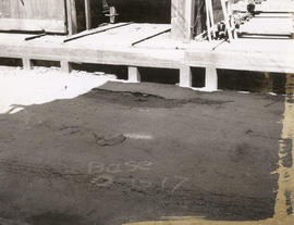
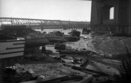
![[Buildings and bridge, 2 of 2]](/uploads/r/null/2/3/3/233119e90a202a70b6aaf8538578b58683dc17af05d65653af449d9b3aa593ea/28d287c7-9b0d-4bdd-a364-ac4123dd1f72-CVA1095-14683_142.jpg)
[Buildings and bridge, 2 of 2]
- COV-S644-: CVA 1095-14683
- Item
- Mar. 1969 - 1973
Part of City of Vancouver fonds
863 results with digital objects Show results with digital objects
[Buildings and bridge, 2 of 2]
Part of City of Vancouver fonds
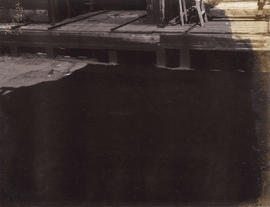
![[Buildings and bridge, 1 of 2]](/uploads/r/null/4/b/7/4b746d60a5edcad5541e0ec05bcd8d839b4335381479f366269d050f7f1df6b9/98aa5923-5c95-49ce-b711-4724c905436c-CVA1095-14682_142.jpg)
[Buildings and bridge, 1 of 2]
Part of City of Vancouver fonds
![[East facing cityscape view of Kitsilano]](/uploads/r/null/9/d/9d09c63567e6331ed970e470005d4e500d48b5731459d17ac756c1c4f0af8606/8d5b2a25-0e5e-43bf-bb36-f9f945d0625b-A59251_142.jpg)
[East facing cityscape view of Kitsilano]
Part of City of Vancouver fonds
Photograph also shows the Granville Street Bridge and the Connaught (Cambie) Bridge.
![WHC APWA [American Public Works Association?] Presentation [27 of 32]](/uploads/r/null/d/7/d73e06bc8f651e7a9c601442d763af5c7d3fdf1750552e87986086a04c40605c/cd12ad9e-3fff-4cca-9c1b-b51fe6c9d367-A69002_142.jpg)
WHC APWA [American Public Works Association?] Presentation [27 of 32]
Part of City of Vancouver fonds
Item is a photograph showing the 1200 block of Powell Street at Clark Drive.
![Burrard Street Bridge from future Expo land [at Vanier Park]](/uploads/r/null/d/a/e/daeb55e9c539444f79ecf58f9e19ec5df81cf48b895d68cbf9aa29e06ff4be9b/8bf1d764-cd93-44c2-b311-40361f33dcff-CVA792-361_142.jpg)
Burrard Street Bridge from future Expo land [at Vanier Park]
Part of City of Vancouver fonds
![Burrard Viaduct Construction [2 of 10]](/uploads/r/null/5/7/57426101abc66a2ab407c951565e28bb07f8f27238a35bb05d7478ded4e540b1/8b87415b-c4bc-4c5c-bf5c-89e3546722c2-A66653_142.jpg)
Burrard Viaduct Construction [2 of 10]
Part of City of Vancouver fonds
Building of Burrard Viaduct with Coal Harbour in the background, including part of Deadman's Island and a floating fuel station on the left and the mountains beyond.
![Burrard Viaduct Construction [1 of 10]](/uploads/r/null/2/7/2788a9638050d7cbfc021e29977d956f423fe6048bb7c29c035ea57bda6dd66c/5df17b4f-3ebf-4f8d-ac21-de11bd89033f-A66652_142.jpg)
Burrard Viaduct Construction [1 of 10]
Part of City of Vancouver fonds
Building of Burrard Viaduct with Coal Harbour in the background, including part of Deadman's Island and a floating fuel station on the left and the mountains beyond.
![Miscellaneous [57 of 130]](/uploads/r/null/c/6/c6ac7a1941eaff56baf25bd599c85c2b53eaec23f10715a53da118f8369f2607/7047af67-11df-45c7-a426-68695b170530-A64388_142.jpg)
Part of City of Vancouver fonds
Item is a photograph showing a view of Boundary Road looking South, near Kingsway with the Canfield Centre building under construction in the background (3777 Kingsway). An overpass is shown in the foreground.
![[Coal Harbour?]](/uploads/r/null/1/0/10b1e3b62444e17b20e5c87b9cb37773568bcad1eb9f6ef2efd8c228b7f06408/5aa04f62-7a7b-4a73-a8bf-7920b9573446-A16631_142.jpg)
Part of City of Vancouver fonds
Photograph shows marsh, water and bridge.
![[Coal Harbour?]](/uploads/r/null/f/b/fb269570031b2a3828f329c97b9db78a5236f47cf4286fb78bf3c2058c53b0de/626b353c-ab4a-4c40-bcaf-41aaec70fe04-A16630_142.jpg)
Part of City of Vancouver fonds
Photograph shows waterfront with bridge, railway tracks and houses.

Sheet 20 : Granville Street to Ontario Street and Robson Street to Sixth Avenue
Part of City of Vancouver fonds
Item is a section showing Granville Street to Ontario Street and Robson Street to Sixth Avenue. Includes streets, roads, blocks, lots, legal descriptions, businesses, crown leases, city leases, the Granville Street and Connaught (Cambie) Bridges, and the False Creek yards. Map is hand coloured to show tax sale property for sale, property with no water, street widening and drainage, replotting, reserved land for schools, reserved land for parks, sundry land, capital assets not including schools and parks, schools, and parks, as applicable.
Vancouver (B.C.). Office of the City Engineer

Part of City of Vancouver fonds

Part of City of Vancouver fonds

Part of City of Vancouver fonds
Part of City of Vancouver fonds
Part of City of Vancouver fonds

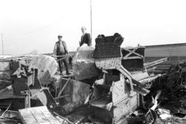
Historic pieces of Cambie Street Bridge etc.
Part of City of Vancouver fonds
Item is a photograph which shows the old Cambie Bridge being torn down for the construction of its replacement. This image was not part of the Heritage Inventory but was taken on the same film.
Historic pieces of Cambie Street Bridge etc.
Part of City of Vancouver fonds
Item is a photograph which shows the old Cambie Bridge being torn down for the construction of its replacement. This image was not part of the Heritage Inventory but was taken on the same film.

Historic pieces of Cambie Street Bridge etc.
Part of City of Vancouver fonds
Item is a photograph which shows the old Cambie Bridge being torn down for the construction of its replacement. This image was not part of the Heritage Inventory but was taken on the same film.

Historic pieces of Cambie Street Bridge etc.
Part of City of Vancouver fonds
Item is a photograph which shows the old Cambie Bridge being torn down for the construction of its replacement. This image was not part of the Heritage Inventory but was taken on the same film.

Historic pieces of Cambie Street Bridge etc.
Part of City of Vancouver fonds
Item is a photograph which shows the old Cambie Bridge being torn down for the construction of its replacement. This image was not part of the Heritage Inventory but was taken on the same film.

Historic pieces of Cambie Street Bridge etc.
Part of City of Vancouver fonds
Item is a photograph which shows the old Cambie Bridge being torn down for the construction of its replacement. This image was not part of the Heritage Inventory but was taken on the same film.

Historic pieces of Cambie Street Bridge etc.
Part of City of Vancouver fonds
Item is a photograph which shows the old Cambie Bridge being torn down for the construction of its replacement. This image was not part of the Heritage Inventory but was taken on the same film.

Part of City of Vancouver fonds

Part of City of Vancouver fonds

Lions Gate Bridge from Brockton Point
Part of City of Vancouver fonds

Lion's Gate Bridge from south, including lion sculptures
Part of City of Vancouver fonds

Lion's Gate Bridge from south, including lion sculptures
Part of City of Vancouver fonds

Tatlow Park, wooden bridge, stream edge looking south
Part of City of Vancouver fonds
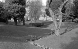
Tatlow Park, wooden bridge, stream edge looking north
Part of City of Vancouver fonds

Tatlow Park, wooden bridge and pool
Part of City of Vancouver fonds

View of boats and debris under Burrard Bridge
Part of City of Vancouver fonds
Item is a photograph showing a cluster of boats, sheds and debris at the foot of Beach avenue, taken from Burrard Bridge.

View of buildings on shoreline from Burrard Bridge
Part of City of Vancouver fonds
item is a photograph showing the foot of Beach Avenue, the shoreline on the north side of Burrard Bridge and Granville Bridge to the east.

Partial view of shoreline under Burrard Bridge
Part of City of Vancouver fonds
Item is a photograph showing a partial view of shoreline under north end of Burrard Bridge.

Partial view of shoreline from Burrard Bridge
Part of City of Vancouver fonds
Item is a photograph showing a partial view looking down on shoreline from Burrard Bridge at the foot of Beach Avenue on east side of Burrard Bridge.

View of shoreline from Burrard Bridge
Part of City of Vancouver fonds
Item is a photograph showing a view looking down on shoreline from Burrard Bridge at the foot of Beach Avenue on east side of Burrard Bridge.

View looking east toward Granville Bridge
Part of City of Vancouver fonds
Item is a photograph showing the shoreline underneath the Burrard Bridge and the view looking east toward Granville Bridge; taken from under north end of Burrard Bridge.
Boats on shoreline under north end of Burrard Bridge
Part of City of Vancouver fonds

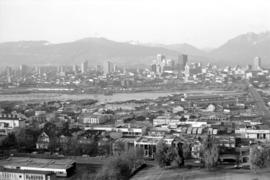
Downtown cityscape over Fairview and False Creek
Part of City of Vancouver fonds
Item part is a photograph of downtown Vancouver over Fairview and False Creek. The Granville Street Bridge and the Burrard Street Bridge are visible at the far left.

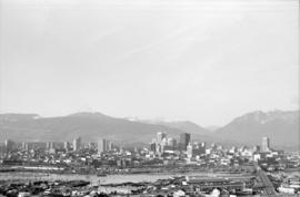
Downtown cityscape over Mount Pleasant, Fairview, and False Creek
Part of City of Vancouver fonds
Item part is a photograph of downtown Vancouver, including a view down Cambie Street across the Cambie Street Bridge, and adjacent neighborhoods in Fairview and Mount Pleasant.

Downtown cityscape over Mount Pleasant, Fairview, and False Creek
Part of City of Vancouver fonds
Item part is a photograph of downtown Vancouver, including a view down Cambie Street across the Cambie Street Bridge, and adjacent neighborhoods in Fairview and Mount Pleasant.
Downtown cityscape over Mount Pleasant, Fairview, and False Creek
Part of City of Vancouver fonds
Item part is a photograph of downtown Vancouver, including a view down Cambie Street across the Cambie Street Bridge, and adjacent neighborhoods in Fairview and Mount Pleasant.

Downtown cityscape over Mount Pleasant, Fairview, and False Creek
Part of City of Vancouver fonds
Item part is a photograph of downtown Vancouver, including a view down Cambie Street across the Cambie Street Bridge, and adjacent neighborhoods in Fairview and Mount Pleasant.

Downtown cityscape over Mount Pleasant, Fairview, and False Creek
Part of City of Vancouver fonds
Item part is a photograph of downtown Vancouver, including a view down Cambie Street across the Cambie Street Bridge, and adjacent neighborhoods in Fairview and Mount Pleasant.

Downtown cityscape over Mount Pleasant, Fairview, and False Creek
Part of City of Vancouver fonds
Item part is a photograph of downtown Vancouver, including a view down Cambie Street across the Cambie Street Bridge, and adjacent neighborhoods in Fairview and Mount Pleasant. The Granville Street Bridge and the Burrard Street Bridge are visible at the far left.
Downtown cityscape over Mount Pleasant, Fairview, and False Creek
Part of City of Vancouver fonds
Item part is a photograph of downtown Vancouver, including a view down Cambie Street across the Cambie Street Bridge, and adjacent neighborhoods in Fairview and Mount Pleasant.

Downtown cityscape over Mount Pleasant, Fairview, and False Creek
Part of City of Vancouver fonds
Item part is a photograph of downtown Vancouver, including a view down Cambie Street across the Cambie Street Bridge, and adjacent neighborhoods in Fairview and Mount Pleasant.

Downtown cityscape over Mount Pleasant, Fairview, and False Creek
Part of City of Vancouver fonds
Item part is a photograph of downtown Vancouver, including a view down Cambie Street across the Cambie Street Bridge, and adjacent neighborhoods in Fairview and Mount Pleasant.