
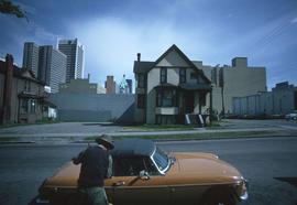
- COV-S509-: CVA 778-35
- Item
- 15 May 1974
Part of City of Vancouver fonds
Image shows the side of an early period house and a vacant lot.
Part of City of Vancouver fonds
Image shows the side of an early period house and a vacant lot.
Part of City of Vancouver fonds
Image shows back of early period house, a vacant lot, and 748 Bute (a house subdivided into suites).
![[House at] 2819 W[est] 7th [Avenue]](/uploads/r/null/8/7/87ea71a50f16fccecb07dbb49dcd4698f291dc050f9b8afd9c82722de201dd2d/c8fe0d9c-3e07-4503-9c2d-f22669992101-A58980_142.jpg)
[House at] 2819 W[est] 7th [Avenue]
Part of City of Vancouver fonds
![[View from beach of Kitsilano waterfront properties]](/uploads/r/null/2/5/25db379fe58fe2addd4525f67aad5af1b7e5388d48d840d1a3c5e74e67b9c224/ab352f4a-06b8-4944-952d-54616b1b6674-A59073_142.jpg)
[View from beach of Kitsilano waterfront properties]
Part of City of Vancouver fonds
![[House at] 2530 Point Grey [Road]](/uploads/r/null/6/e/6e23accc5a3fa9a787cd4e9606cae61717acc82aa80c2fb40007ce50f1ab75d2/dd23ee5a-0d39-4484-9863-388151062455-A59075_142.jpg)
[House at] 2530 Point Grey [Road]
Part of City of Vancouver fonds
![[House on the corner of West] 67th [Avenue and] Selkirk [Street]](/uploads/r/null/8/5/85ba2a607ff697e0ba6c73cb4cc04302fe543e40d68bffa33b060447b2611808/ce4165f1-efc6-487d-9c27-8a3b5b36bc8f-A59083_142.jpg)
[House on the corner of West] 67th [Avenue and] Selkirk [Street]
Part of City of Vancouver fonds
![[House at] 330 E[ast] 8th [Avenue]](/uploads/r/null/c/5/c588240b945c4341fc0a6a8af9e399c80b8a4372fdc654c0581f63ff3cb20183/ae45a5b2-7d8d-4bd8-8e96-6cd13b8ee54f-A59115_142.jpg)
[House at] 330 E[ast] 8th [Avenue]
Part of City of Vancouver fonds
![[View of East] 14th [Avenue at] Pr[ince] Albert [Street]](/uploads/r/null/0/1/010770a09e6b951038e7dad4c2ce27438a83fb7350925f78117330ce85476fd0/94ceafce-9318-4281-b19c-84263016beee-A59118_142.jpg)
[View of East] 14th [Avenue at] Pr[ince] Albert [Street]
Part of City of Vancouver fonds
Photograph also shows houses along East 14th Avenue
![[House at] 2646 Yukon [Street]](/uploads/r/null/6/2/62ed01eb83dd78d78a556c4a5df48dd36d5b75ada70d5443c7ccf116c17846bd/8ad4c9e7-eb9d-4b00-bd4e-47395484b7aa-A59119_142.jpg)
[House at] 2646 Yukon [Street]
Part of City of Vancouver fonds
![[Townhouses in Riley Park]](/uploads/r/null/3/7/37ce90048d4c79062e5d29d35896ff5f844abe12b757863d80f0a35dcc50dcdf/0a64931d-c658-42f9-aaf5-b708b8919603-A59150_142.jpg)
Part of City of Vancouver fonds
![[House in Grandview-Woodland]](/uploads/r/null/9/d/9d91c5e259d404534253bef4a921e82cffbc1c751b16fe3dd9fbd83a405d7826/b6068518-8171-4f5b-b8d3-6aba5790ac0c-A59178_142.jpg)
Part of City of Vancouver fonds
![Strath[cona] Rehab[ilitation]](/uploads/r/null/0/2/02b1fed48044b74102e9925a7d95d4e41c852514c6df4fa62c81951fda863407/96950589-6fda-44af-b35b-66aab9e359d9-A59208_142.jpg)
Part of City of Vancouver fonds
Photograph shows houses and apartment buildings on Jackson Avenue and Union Street looking south to Prior.
![[Cordova Street looking west at Jackson Avenue.]](/uploads/r/null/7/b/7b6818d1a76e50216589304905b401c5dedf6da81e2e67f846e8bdbf8f7ab8c7/ae00d516-b739-47f5-b32a-672eb41756a5-A59214_142.jpg)
[Cordova Street looking west at Jackson Avenue.]
Part of City of Vancouver fonds
![[Houses in Strathcona]](/uploads/r/null/2/7/2729ed339f2c109b61bade7ac85a5691c57dfa1d7ca55b881a47b200a56dac0b/6588967d-4c7c-4f15-9f9f-99195b72c736-A59218_142.jpg)
Part of City of Vancouver fonds
![[House at] 250 E[ast] Georgia [Street]](/uploads/r/null/8/3/838a26beee526c5158c5ca15caba4bec3a66dbcedbaa4686c05f58d3e35e973c/80fd5ddf-86d2-43c4-81cf-9c47e51702d8-A59223_142.jpg)
[House at] 250 E[ast] Georgia [Street]
Part of City of Vancouver fonds
Photograph also shows the buildings on either side of the house
![[Cityscape view of the] 1000 block Pacific [Street]](/uploads/r/null/8/a/8a59a18378e865a06b1356432c75fb681219f21edfdcdb8558ca1272591fed46/01e90ee3-0a1b-4ca9-963e-b178828b9c93-A59272_142.jpg)
[Cityscape view of the] 1000 block Pacific [Street]
Part of City of Vancouver fonds
Photograph shows houses and apartment buildings
![[Houses in the] 1300 block Burnaby [Street]](/uploads/r/null/9/b/9bdae51807d4be5f3f90fe220e5e7b18199987c8dadb394d50ffbd97f7fb6646/f6b6fc43-c62f-4366-8592-5e3edcba2c3f-A59279_142.jpg)
[Houses in the] 1300 block Burnaby [Street]
Part of City of Vancouver fonds
![Single family [housing in West Point Grey]](/uploads/r/null/3/b/3bf005a518caada44b89195956bcffe37684e66e34ba26191d78bef649f188f4/2ccdae92-0db3-45c9-9387-e7926ce2fdf0-A59301_142.jpg)
Single family [housing in West Point Grey]
Part of City of Vancouver fonds
![Rear [view of houses along] Hamilton [Street] between Smithe [Street] and Robson [Street]](/uploads/r/null/9/a/9aa4625880ae56bca6ef7abcc82ded9f1b3437c35b17901c1528db13e441bd4d/9c6d12ff-4db0-42ab-8da3-31f82751cd40-A59837_142.jpg)
Rear [view of houses along] Hamilton [Street] between Smithe [Street] and Robson [Street]
Part of City of Vancouver fonds
![[House at] 811 Hamilton [Street]](/uploads/r/null/7/d/7d6d10abe5f46c7b2aafced70ea6ccb9cba43ffe092a64d2efdf33296184e9cb/4fe03158-47d8-46df-aa15-053efa143a28-A58824_142.jpg)
[House at] 811 Hamilton [Street]
Part of City of Vancouver fonds
![[Houses along the 1000 block] 14th Ave [W, between] Spruce [Street and] Oak [Street;] Apartment R...](/uploads/r/null/6/a/6a6d52ecafd6bbf63a592886849c253bbe1167e95661c28860e26b5484c99957/d7c23516-512a-46a4-9e5d-955151674977-A58847_142.jpg)
Part of City of Vancouver fonds
![[Houses along the 1100 block] 14th Ave [W at the 3000 block Spruce;] Apartment study of housing](/uploads/r/null/3/4/344b63fcb11ac719b7b61b244df6affe46d27dd6e9499b51d619548f2be6e60e/b1c65cec-326c-4ff9-8cc2-029fbd532c49-A58848_142.jpg)
[Houses along the 1100 block] 14th Ave [W at the 3000 block Spruce;] Apartment study of housing
Part of City of Vancouver fonds
![[House number 1145 on a street in Fairview]](/uploads/r/null/2/6/2650630764d6d0ca0ab12bea61e345e2315b79c24d3c55c9937002d3dacbe885/a72e98d1-eb8e-4508-b43e-ef2d475de326-A58860_142.jpg)
[House number 1145 on a street in Fairview]
Part of City of Vancouver fonds
![[Houses along] McLean Drive](/uploads/r/null/4/d/4df74616417b8b11b99accb5aa63dbdc03cf6e536155d6330dad2ab7666f896a/f2f2010a-a21e-4e72-93a1-a96244a39b54-A58898_142.jpg)
Part of City of Vancouver fonds
![[House at] 590 Kamloops [Street]](/uploads/r/null/8/2/8244b1302e5fa7b58084a88d032bbe60abd7a3156454f7d2d6ef634ea723fb20/76b1f1f1-873e-4624-8084-c22d1ef968bb-A58902_142.jpg)
[House at] 590 Kamloops [Street]
Part of City of Vancouver fonds
![[House at] 2223 Oxford [Street]](/uploads/r/null/5/8/5812e1a70da94fafcbc6e78b7e5dfd74c49b78b4c34e2d6d0406ab23f5ad2269/2f31108c-4329-49fb-8f40-fab8fc18967e-A58904_142.jpg)
[House at] 2223 Oxford [Street]
Part of City of Vancouver fonds
![[Houses] 2487-2439 [along] Eton [Street]](/uploads/r/null/4/2/42ef50c1897ced1361b9d9a74444a740863e0d3144c8bd7e90f342d6b7a53c6c/530b86af-1fe8-4f8c-8fb1-bcbddd14b628-A58905_142.jpg)
[Houses] 2487-2439 [along] Eton [Street]
Part of City of Vancouver fonds
![[House at the] N[orth] E[ast] corner [of] Lakewood [Drive] and Kitchener [Street]](/uploads/r/null/6/b/6b4fc065781ac2b164c4d2ba1ee7c2e8efffd3e7527345185239a8d4c4f83254/20e9d452-5058-414e-bf85-d89e3b005dea-A58908_142.jpg)
[House at the] N[orth] E[ast] corner [of] Lakewood [Drive] and Kitchener [Street]
Part of City of Vancouver fonds
![[Homes by Sharp, Thompson, Berwick and Pratt Architects on Knight Road]](/uploads/r/null/1/3/13bdd14942b6872910266ee6c0394fd551cca6f42c9373a635985fe80ed9e7cd/fcc13dd3-1709-4fc8-8af7-060022e4dc0b-A42453_142.jpg)
[Homes by Sharp, Thompson, Berwick and Pratt Architects on Knight Road]
Part of City of Vancouver fonds
![255 Prior Street [front]](/uploads/r/null/b/0/b0b4614e499b1b64d23aa9b0b7a8d494bfdfecff7fb3cd1d2635d3f25f472da5/f00971d6-b4de-486d-94c1-1794e0c46a24-A59019_142.jpg)
Part of City of Vancouver fonds
Photograph also shows 251 Prior Street.
![232 - 240 Union Street [back]](/uploads/r/null/6/a/6abdd8c0df7eef2791f10604d7bc4fe7f4bdd3bf6a1ce0815b396946dff5e571/c8cd339c-176d-4b23-8e3b-99c3c6a61d6b-A59039_142.jpg)
Part of City of Vancouver fonds
![248 - 250 Union Street [front]](/uploads/r/null/0/1/014d1dc53b6ed6f8358925afb23cee24e67b65abc293bfe4d445432f1b46aa60/9de497b0-7ec7-4ce4-b5b2-b5a460572ad4-A59040_142.jpg)
248 - 250 Union Street [front]
Part of City of Vancouver fonds
![264 Union Street [back]](/uploads/r/null/9/9/9935f4334716951d5ed0bc666d6a317c0c061ac36a1417f37a957d580a437e94/a76d26d0-1b8d-4972-adf2-db9f7fe6215f-A59043_142.jpg)
Part of City of Vancouver fonds
Photograph also shows part of 268 Union Street.
![274 [- 278] Union Street [back]](/uploads/r/null/7/c/7c42905e45c4d270d410b06ba114b4a0ada5f1f8d390704ba0bc357a3ce4e667/89f2d94d-0e0e-40d0-9d3a-effa5281d2c9-A59051_142.jpg)
274 [- 278] Union Street [back]
Part of City of Vancouver fonds
Photograph shows Union Laundry and portion of a house (back of 278 Union Street)
![274 [- 278] Union Street [back]](/uploads/r/null/c/2/c2a21a6ac3bdc852dceae73b99abf16d7a11a98d0d50bd40b0222aba0dda72ee/7cb78922-e1cd-4859-8402-6b324349f3b4-A59052_142.jpg)
274 [- 278] Union Street [back]
Part of City of Vancouver fonds
Photograph shows Union Laundry and portion of a house (back of 278 Union Street)
![[Houses at] 278 [Union Street] and 809 Gore [Avenue]](/uploads/r/null/6/4/64100bb23754f1e398e2ba851c15151df6597728236eb8348ffe43b6b2e1704f/b914e1c0-496d-4c85-83e1-0bfa9ce31e90-A59054_142.jpg)
[Houses at] 278 [Union Street] and 809 Gore [Avenue]
Part of City of Vancouver fonds

Part of City of Vancouver fonds
Part of City of Vancouver fonds

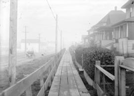
Harris St. Obstruction to Sidewalk
Part of City of Vancouver fonds

Looking north on Oak Street at West 16th Avenue
Part of City of Vancouver fonds
Photograph shows construction of the electric street railroad, businesses in the 3100 block Oak Street, Leo Service station (3095 Oak Steet), Huntly Lodge (3050 Oak Street), 3027 Oak Street and Athol Apartments (2970 Oak Street).
Eddington Drive, south side, from Haggart Street to Paton Street - view west
Part of City of Vancouver fonds
Photograph shows 4675 Haggart Street and 2404 and 2406 Eddington Drive

Slocan Street, west side, 1st to 2nd Avenues - view northwest
Part of City of Vancouver fonds
Photograph shows 2697 and 2691 East 2nd Avenue and a part of 2696 East 1st Avenue

Slocan Street, west side, 6th to 7th Avenues - view northwest
Part of City of Vancouver fonds
Photograph shows 2275 Slocan Street, 2693 East 7th Avenue and the rear of 2696 East 6th Avenue
![Nanaimo and Dundas [Streets looking] south](/uploads/r/null/5/1/51204e8d2ecc1da566752e55be969d974b80f1e305caaff20f4facd2dde90fea/666d2df2-bd81-4d6d-a96e-4ddeab13adb8-A44133_142.jpg)
Nanaimo and Dundas [Streets looking] south
Part of City of Vancouver fonds
![Prince Edward [Street] and King Edward [Avenue looking] east](/uploads/r/null/8/7/8775a0eb6a44a0717d03186b76cf14d857b7859ea7580dfcc8e3f925c1035258/f84924e8-e235-40d1-9cdc-98cc6274c3bc-A44207_142.jpg)
Prince Edward [Street] and King Edward [Avenue looking] east
Part of City of Vancouver fonds
![Victoria [Drive] and 12th [Avenue looking] west](/uploads/r/null/e/5/e5fcbc967a3ebd98020473e412d84979d8fbafc118e5cc093e29455841ffcb6c/42d00951-5061-4ba3-a1c3-7805a9c37baa-A44459_142.jpg)
Victoria [Drive] and 12th [Avenue looking] west
Part of City of Vancouver fonds
![10th Avenue and Balaclava [Street] looking west](/uploads/r/null/0/7/078fc29e9e1b4dabd6b9394865959bb8c42ff99fbc72643e6294786005282a0a/8cb87542-bc4b-4a50-9c07-015e00e64b7b-A44540_142.jpg)
10th Avenue and Balaclava [Street] looking west
Part of City of Vancouver fonds
![10th Avenue and Balaclava [Street] looking north](/uploads/r/null/d/4/d42c01c03fe0934e2be043f2b89c8ce6a48befc077ebaedf244f49614d29cc8d/14c67598-8562-4d38-bf7a-ddf676f3cecd-A44543_142.jpg)
10th Avenue and Balaclava [Street] looking north
Part of City of Vancouver fonds
![Glen [Drive] and 12th [Avenue] looking south](/uploads/r/null/e/3/e330254787a179606f59147522e99d38d5322fd936cc6a7a0854f2ab2a51ffc5/0e4dac8b-df34-4d35-8922-a3b93873b037-A44551_142.jpg)
Glen [Drive] and 12th [Avenue] looking south
Part of City of Vancouver fonds
![Glen [Drive] and 12th [Avenue] looking west](/uploads/r/null/e/6/e64ebc84094a7aefdafcfbf6b62f6e524cc67948c10fea6c9fe80cfedba2bc9f/f3a31cbd-5b9f-43dd-a9f7-0122f6f12505-A44556_142.jpg)
Glen [Drive] and 12th [Avenue] looking west
Part of City of Vancouver fonds