
View of British Columbia Permanent Loan Company building at 330 West Pender Street
- VPK-S625-: CVA 392-1191
- Item
- ca. 1965
13238 results with digital objects Show results with digital objects
View of British Columbia Permanent Loan Company building at 330 West Pender Street
![[Vancouver Police officers and vehicles assembled in front of Public Safety Building]](/uploads/r/null/8/b/4/8b4e5b4eaf8d656c2a02e0cf0d88128384c0fef85dc00ffebadbf333fb5e34f1/5e3e4597-8dc9-4bed-a357-2db82544bce5-CVA480-323_142.jpg)
[Vancouver Police officers and vehicles assembled in front of Public Safety Building]
Item is a photograph showing the building at 312 Main Street taken from a rooftop across the street.
![[Exterior view of] 1363 Howe Street, Vancouver Police Training Academy](/uploads/r/null/1/1/1/111585b311856e6cdc2b6332798c26b8ab5e9bb06383083bf3d9487bb039deb6/b1a051c2-1b73-4602-a076-42549d3c37b3-CVA480-320_142.jpg)
[Exterior view of] 1363 Howe Street, Vancouver Police Training Academy
![[View of parking lot located on Main Street between Alexander and Powell Streets]](/uploads/r/null/6/6/8/66821bfb06eee5731b7056b5651dfad1caf7d1371a185a0469b33473236ebf35/ec162029-62c2-4f13-8106-9e610d6f7024-CVA480-306_142.jpg)
[View of parking lot located on Main Street between Alexander and Powell Streets]
Item is a photograph showing cars in the parking lot and painted advertisements on surrounding buildings for Army & Navy Department Stores, Coca-Cola, Burrard Iron Works and other storefronts.

Part of City publications collection
Item is a map showing streets, building footprints and number of storeys.

Part of City publications collection
Item is a map showing streets, building footprints and number of storeys.
Part of City publications collection
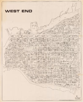
Item is a map showing streets, building footprints, number of storeys, topographic contour lines, and street codes according to a system adopted by the Engineering Department in the mid-1960s.

Part of City publications collection
Item is a map showing streets, building footprints, number of storeys, and street codes according to a system adopted by the Engineering Department in the mid-1960s.
![WHC APWA [American Public Works Association?] Presentation [5 of 32]](/uploads/r/null/c/4/c47d741b09b871881c90a84ba49855e244f169d0026971cf0956a33ecce0e74c/eead1ea2-7898-435d-acf8-c3e3b6b250c1-A68968_142.jpg)
WHC APWA [American Public Works Association?] Presentation [5 of 32]
Part of City of Vancouver fonds
Item is a photograph showing City Hall.
![Miscellaneous [117 of 130]](/uploads/r/null/a/4/a49076bf7f21e2d357296433bc7fd1ea2256b52579a7bbc9d0d5d8d441bbff5d/e3382963-8663-4ddd-adee-5344f82b64b8-A67549_142.jpg)
Part of City of Vancouver fonds

British Columbia Parliament Buildings
Part of City of Vancouver fonds
Item shows the British Columbia Parliament Buildings home to the Legislative Assembly of British Columbia, Victoria.
![Miscellaneous [105 of 130]](/uploads/r/null/4/5/4503da9402e969c192a6cf1aaf0ccc24984df5ccb85d50923c1ae3608036d046/833b22c7-b478-4eed-adbb-5e3ad9778080-A67537_142.jpg)
Part of City of Vancouver fonds
![Miscellaneous [103 of 130]](/uploads/r/null/6/b/6b110a5dcb198fe50cd693c08217a7c1e1af4f4a89ec572715d38d5ce6f0cb44/2c71c224-c28e-4366-81f6-a5f00e629bb1-A67535_142.jpg)
Part of City of Vancouver fonds
![Miscellaneous [72 of 130]](/uploads/r/null/1/b/1b97fb27b4a2d325539d0a57fdfe65120517c6a3bc3570096d617736dc1e0bd2/c9f5f293-7020-414c-b206-e9791f79b002-A67504_142.jpg)
Part of City of Vancouver fonds
![Infrastructure and 1987-1990 Capital [25 of 138]](/uploads/r/null/d/d/dd269a217e25d88ce6c85ceb4dd226607c50665fea19e5744c3f10b0e1bcc16c/988ef4cc-ac8f-48cb-81a6-790a7914de27-A67046_142.jpg)
Infrastructure and 1987-1990 Capital [25 of 138]
Part of City of Vancouver fonds
![Infrastructure and 1987-1990 Capital [24 of 138]](/uploads/r/null/5/9/59bb5bd7426f760daca1f2292e163f8f3a1cae560a33039e76c8709ece9a7d4e/ae084adb-5cf2-4ac3-bad8-d7b952e7f1b1-A67045_142.jpg)
Infrastructure and 1987-1990 Capital [24 of 138]
Part of City of Vancouver fonds
![Infrastructure and 1987-1990 Capital [23 of 138]](/uploads/r/null/7/e/7e20e5e8ab86129689a1918e55a8d19011fb24d321135fa03ee9746d7e319425/c4b0cf8d-3233-4924-bdde-c0b9ee3cba9b-A67044_142.jpg)
Infrastructure and 1987-1990 Capital [23 of 138]
Part of City of Vancouver fonds
![Infrastructure and 1987-1990 Capital [22 of 138]](/uploads/r/null/1/c/1ceaceafc1224e009ab4221faa35bae3d7c4f6e4cc75c38c89ed766fb14d81f3/15519dc3-934b-4dc8-91de-12d808c720be-A67043_142.jpg)
Infrastructure and 1987-1990 Capital [22 of 138]
Part of City of Vancouver fonds
![Infrastructure and 1987-1990 Capital [21 of 138]](/uploads/r/null/f/9/f9dc7172772f2278a34eec7957e445081d1c0c08b7b348f78f90f8336a02bf87/6e013ca6-92dc-4c3d-a3a7-a487d502b434-A67042_142.jpg)
Infrastructure and 1987-1990 Capital [21 of 138]
Part of City of Vancouver fonds
![Infrastructure and 1987-1990 Capital [20 of 138]](/uploads/r/null/a/c/ac2f79757f7ce4500cb7df3317da3fb8bf34e9e560e2f4c6e682b4e50d7547f4/26aebaf5-a3d8-4a85-9175-01b890321592-A67041_142.jpg)
Infrastructure and 1987-1990 Capital [20 of 138]
Part of City of Vancouver fonds
![Infrastructure and 1987-1990 Capital [19 of 138]](/uploads/r/null/5/e/5e154161aadf7c0c87ef8c14a435aec1ef01866026ae925e17ba3cfa6228486c/0fafd998-cc4f-49b7-91d3-b11f2f5f5766-A67040_142.jpg)
Infrastructure and 1987-1990 Capital [19 of 138]
Part of City of Vancouver fonds
![Infrastructure and 1987-1990 Capital [18 of 138]](/uploads/r/null/b/6/b6c8b28735dda654e5bebb8d3358fd0193dfc1af39562b4c050822c54ccc364a/09cb601f-dfe9-4d16-8c07-aaaea10c8171-A67039_142.jpg)
Infrastructure and 1987-1990 Capital [18 of 138]
Part of City of Vancouver fonds
![Infrastructure and 1987-1990 Capital [17 of 138]](/uploads/r/null/0/3/0363eedd0b3084022987df30bf564b54be7264b7d714d5094dc4aea90cd872d9/c3d04d2c-0244-4c86-b81e-8cf4121467cc-A67038_142.jpg)
Infrastructure and 1987-1990 Capital [17 of 138]
Part of City of Vancouver fonds
![Cityscape [3 of 16]](/uploads/r/null/1/1/113362fa3fe4b50a19fdac9053273dc6622e04b5b21a35989c3becce0ef62dba/1a32affc-0772-4a49-84a9-295338a56467-A66157_142.jpg)
Part of City of Vancouver fonds
![Cityscape [2 of 16]](/uploads/r/null/0/5/054ac0b7f29d57859ab09b04d66952d9dbeb15353f0f4f8c1e97e89e8fc935f6/832f8179-4710-4ebf-8824-7eb17d97c9e8-A66156_142.jpg)
Part of City of Vancouver fonds
![Cityscape [1 of 16]](/uploads/r/null/2/b/2bdbafa2e214923e658beea80944c5c66b6d0ed374eeed87fe5f15c6f3d53b93/3f7c562e-087a-44f3-9676-e56fa25889db-A66155_142.jpg)
Part of City of Vancouver fonds
![Cityscapes [16 of 16]](/uploads/r/null/b/7/b7667822b216995a57d222274b72bd43312c9e95aa86247deb3ad6ccd27484b3/4a41b521-088c-4ad6-bcbd-f66ea684f237-A66154_142.jpg)
Part of City of Vancouver fonds
![Cityscapes [15 of 16]](/uploads/r/null/5/1/5142e0b083338c6d763f4f26e851bd740d64e0c9c806eae353716bf7f42817b3/6e1cbbc4-185d-47e7-a75f-5672adae116f-A66153_142.jpg)
Part of City of Vancouver fonds
![Cityscapes [14 of 16]](/uploads/r/null/d/c/dc8b6f46c6da6df6153b29b4f482318112d613003e863ee7e202f34c821e6d44/554363ed-722d-4ea1-934b-4ed83687cc9e-A66152_142.jpg)
Part of City of Vancouver fonds
![Cityscapes [13 of 16]](/uploads/r/null/2/5/25bb98d9339b0d77dec78c2cfda2270ecc7dea0d89abbc2ad17661693415b360/a2925e9d-8119-44ba-8cce-e020077ffe6a-A66151_142.jpg)
Part of City of Vancouver fonds
![Cityscapes [12 of 16]](/uploads/r/null/b/a/ba822ca521a9ddde92e26be32d085bdd73fb7a043ea810a0232f43577aac41b0/0a194d9e-c80c-4c91-9cf1-e6ab98ca7048-A66150_142.jpg)
Part of City of Vancouver fonds
![Cityscapes [11 of 16]](/uploads/r/null/6/4/6434c71eb8fd42ef6be57e5fd4c322cadf393b8d170ece56a5ce40cbc4711b60/0143c4f9-db95-4780-81b0-ef394b33b181-A66149_142.jpg)
Part of City of Vancouver fonds
![Cityscapes [10 of 16]](/uploads/r/null/4/1/4175e8b30caf66fda910add640ef21dc6bb0c627cb7a6a1faf8944a1dbd90552/4cce59c4-efdf-4e37-8ec5-ce0da5b5f2c7-A66148_142.jpg)
Part of City of Vancouver fonds
![Cityscapes [9 of 16]](/uploads/r/null/3/4/34e0757ad07a6cad17d8633d43ef73c8dea854d720aaf343b5f2702c1c2fb6ac/4717f7d7-6c29-4ef1-bea3-a51d4cb027af-A66147_142.jpg)
Part of City of Vancouver fonds
![Cityscapes [8 of 16]](/uploads/r/null/b/3/b31eec8a3c82cee3ce154505eced1e5b194b78fcf792c9c59fe0204008d532f2/2cd8bdda-7762-41f0-93dd-430f08b6d8d6-A66146_142.jpg)
Part of City of Vancouver fonds
![Cityscapes [7 of 16]](/uploads/r/null/b/4/b4b359f40cf2c5a86eda4dc25c9c00ecc1c09a47710344e1a6e842ab885acad7/f2235b0e-4c20-42cd-968d-dc884166b483-A66145_142.jpg)
Part of City of Vancouver fonds
![Cityscapes [6 of 16]](/uploads/r/null/6/0/60c919e64c6693ce343576e1f3f3b3a5dbc253a1e9eb9b246f0284ef08413261/4436528c-4b57-420a-858f-0a565aa47925-A66144_142.jpg)
Part of City of Vancouver fonds
![Cityscapes [5 of 16]](/uploads/r/null/c/2/c2f2d297302fa554cff1f17b6190e01b6d3b437f44ea987f73ec7283aab5d49d/1c81641f-4647-4381-ad8c-8edc6b0f3f3e-A66143_142.jpg)
Part of City of Vancouver fonds
![Cityscapes [4 of 16]](/uploads/r/null/4/8/48e1d6f8b1222bdbf9a7d9328ecc76249e71dc85cd0419bc1f8d96dfe6743703/35e42530-6b3f-49de-9e6f-aa582bc5b97a-A66142_142.jpg)
Part of City of Vancouver fonds
![Miscellaneous [57 of 130]](/uploads/r/null/c/6/c6ac7a1941eaff56baf25bd599c85c2b53eaec23f10715a53da118f8369f2607/7047af67-11df-45c7-a426-68695b170530-A64388_142.jpg)
Part of City of Vancouver fonds
Item is a photograph showing a view of Boundary Road looking South, near Kingsway with the Canfield Centre building under construction in the background (3777 Kingsway). An overpass is shown in the foreground.
![Miscellaneous [49 of 130]](/uploads/r/null/b/1/b1e9e3e02c21c26fb7412de9dce7bf1f3722b3de4a610190d214c097fb13ecb7/4e89064b-2299-4689-bc00-c477abb6e3c8-A64380_142.jpg)
Part of City of Vancouver fonds
Item is a photograph showing a view of the Canfield Centre building at 3777 Kingsway at Boundary Road.
![Miscellaneous [32 of 130]](/uploads/r/null/0/4/046ad8f5945d1d2fe2162960a1d0225e77ac9be4da49f5bf2425dc3a6c892bfc/bab90f10-8869-45c2-bab9-cf4837cdee9d-A64355_142.jpg)
Part of City of Vancouver fonds
Item is a photograph showing a view of Boundary Road looking South, near Kingsway with the Canfield Centre building under construction in the background (3777 Kingsway).
![Streets [109 of 139]](/uploads/r/null/3/0/3066f649e6dc5de1ab5a37c765cf8f4c6bf1f8a2bb354033fd9b96669d15f88d/69f39e97-3920-4c52-9992-1e26e5eef692-A64352_142.jpg)
Part of City of Vancouver fonds
Image shows Vancouver City Hall.
![Streets [108 of 139]](/uploads/r/null/c/f/cfc2ae23ae63b1dfe8e64aa935b4b870facb29a3a80a91e3f59ecb46a27b864c/bda5415d-b4ec-4f8b-9e3c-78d654e2837e-A64351_142.jpg)
Part of City of Vancouver fonds
![Streets [106 of 139]](/uploads/r/null/c/5/c5f8d5e359ee266d899625e1d347451b29d2437cefe319e35edf9a594259240a/7b0a75e3-395c-443c-b5cb-15daa612fae0-A64349_142.jpg)
Part of City of Vancouver fonds
![Streets [105 of 139]](/uploads/r/null/2/6/26970be2546d33160a31d473de18c988eee35a9f637e9ccd9d3adc460a71e786/fa73545e-f937-4ba1-94f2-ebf300218cac-A64348_142.jpg)
Part of City of Vancouver fonds
![Streets [104 of 139]](/uploads/r/null/9/6/960c88983c7a9279224aeddac40ab470d9b019bf1a248e5052efd0301f978c9b/1ded6a36-fb66-42bc-b9b7-159f3b49171c-A64347_142.jpg)
Part of City of Vancouver fonds
![Miscellaneous [6 of 130]](/uploads/r/null/8/c/8c3a6495a41e8fa2890ff40a5c15b44afb4c4fb9b848291917367395507cff5e/85dd080a-fed7-4600-be12-4062980e15e9-A64294_142.jpg)
Part of City of Vancouver fonds
Item is a photograph showing the Iona Island Sewage Treatment Plant.
![[View of Mount Pleasant]](/uploads/r/null/0/c/9/0c9db5e81df211f273f5e890c4cf2f482734489cf47c53831e2f430410336c9b/259201ec-18df-4a3e-9317-7b6aa211e33b-CVA808-9_142.jpg)
Part of City of Vancouver fonds
![[View of Mount Pleasant]](/uploads/r/null/9/c/d/9cdedd7465a41bd387e640cf629625fb867c074fe7a89a2eacf6d02d89268aae/aef32311-b1a1-4f41-88c3-68eb30b0cf98-CVA808-8_142.jpg)
Part of City of Vancouver fonds
Photograph is taken of the 500 block of East 5th Avenue.