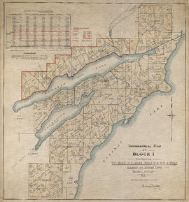
Topographical map of Block 1 containing T.L.s 8043-4-5, 8048, 8054-5-6-8-9 & 8086
- AM893---: 1985-029.20
- Item
- July 1918
Part of Eustace Smith Ltd. fonds
105 results with digital objects Show results with digital objects
Topographical map of Block 1 containing T.L.s 8043-4-5, 8048, 8054-5-6-8-9 & 8086
Part of Eustace Smith Ltd. fonds

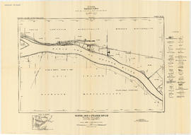
Fraser River - Sand heads sheet
Part of City of Vancouver Archives technical and cartographic drawing collection

Part of City of Vancouver Archives technical and cartographic drawing collection

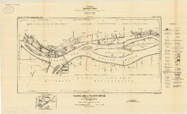
Fraser River - Steveston sheet
Part of City of Vancouver Archives technical and cartographic drawing collection

Fraser River - Deas Island sheet
Part of City of Vancouver Archives technical and cartographic drawing collection

Fraser River - Tilbury Island sheet
Part of City of Vancouver Archives technical and cartographic drawing collection

Fraser River - Annacis Island sheet
Part of City of Vancouver Archives technical and cartographic drawing collection

Fraser River - New Westminster sheet
Part of City of Vancouver Archives technical and cartographic drawing collection

Fraser River - Port Mann sheet
Part of City of Vancouver Archives technical and cartographic drawing collection
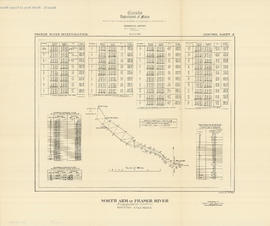
North Arm of Fraser River - Boundary Road sheet
Part of City of Vancouver Archives technical and cartographic drawing collection

North Arm of Fraser River - Poplar Island sheet
Part of City of Vancouver Archives technical and cartographic drawing collection

Burrard Inlet - Vancouver sheet
Part of City of Vancouver Archives technical and cartographic drawing collection

North Arm of Fraser River - Ione Island sheet
Part of City of Vancouver Archives technical and cartographic drawing collection
North Arm of Fraser River - Marpole sheet
Part of City of Vancouver Archives technical and cartographic drawing collection

North Arm of Fraser River - Point Grey sheet
Part of City of Vancouver Archives technical and cartographic drawing collection

Burrard Inlet - Dollarton sheet
Part of City of Vancouver Archives technical and cartographic drawing collection

Burrard Inlet - Second Narrows sheet
Part of City of Vancouver Archives technical and cartographic drawing collection

Part of City of Vancouver Archives technical and cartographic drawing collection

Burrard Inlet - Port Moody sheet
Part of City of Vancouver Archives technical and cartographic drawing collection

Fraser River - triangulation control
Part of City of Vancouver Archives technical and cartographic drawing collection
North Arm of Fraser River - triangulation control
Part of City of Vancouver Archives technical and cartographic drawing collection

Burrard Inlet - triangulation control
Part of City of Vancouver Archives technical and cartographic drawing collection

North America. West Coast. Fraser River and Burrard Inlet
Part of City of Vancouver Archives technical and cartographic drawing collection
Item is a nautical chart which show details of area surveyed from Pitt Lake in the north to Roberts Bank in the south and from (what is now) Harrison Hot Springs in the east to Bowen Island in the west. The chart shows soundings in Burrard Inlet, and along the Fraser River.

Garibaldi Lake study 1932-1933
Part of City of Vancouver fonds
Item is a graph depicting gauge water heights for Lesser Garibaldi Lake, Garibaldi Lake, Upper Rubble Creek, Lower Rubble Creek for the period Apr. 1932 to Apr. 1933.

Chilliwack Lake scheme & Jones Lake scheme
Part of City of Vancouver fonds
Item is a map depicting proposed hydro-electric development north-west of Chilliwack Lake. The map shows the location so proposed dams, flumes, tunnels and the location of a power house on the Fraser River west of Jones Lake.
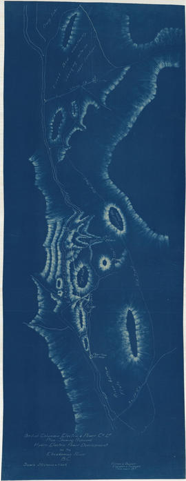
Plan shewing proposed hydro-electric power development on the Cheakamus River B.C.
Part of City of Vancouver fonds

Plan of Pemberton valley from District Lot 758 to Lillooet Lake
Part of City of Vancouver fonds

Part of City of Vancouver fonds
Item is an architectural drawing sheet depicting a plan and section of the intake on the Bridge River, and the power house on Seton Lake.

Plan of proposed development of hydro-electric power. Bridge River
Part of City of Vancouver fonds
Item is a map sheet containing a plan and profile of a proposed hydro-electric development tunneling water from the Bridge River to a power plant on Seton Lake. The main map shows the plan of the overall development; the inset map is a Key Plan showing the location of the development within British Columbia.

Lower Lillooet River - Harrison Lake to Tipella trail
Part of City of Vancouver fonds

Lower Lillooet River - Tipella trail to Bear Lake
Part of City of Vancouver fonds

Lower Lillooet River - Bear Lake to Gowan Creek
Part of City of Vancouver fonds

Lower Lillooet River - Gowan Creek to Rogers Creek
Part of City of Vancouver fonds

Lower Lillooet River - Rogers Creek to Billygoat (29 Mile) Creek
Part of City of Vancouver fonds

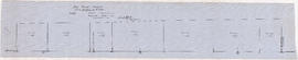
Profile 6 Mile Creek from 2+4240 to 3+1990
Part of City of Vancouver fonds

Profiles of sections of Green & Soo Rivers
Part of City of Vancouver fonds

Part of City of Vancouver fonds
Item is a map sheet containing two profiles: one showing the increased reservoir height with a subsidiary dam built and the other a profile of the proposed subsidiary dam site.
Soo River profile from 6+3820 to 9+2380
Part of City of Vancouver fonds

Profile on possible dam sites across Soo River at 2+4340
Part of City of Vancouver fonds

Soo River profile from 9+2380 to 15+1650
Part of City of Vancouver fonds

Soo River profile from Green River junction west 6 miles 3820 ft
Part of City of Vancouver fonds

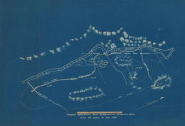
Proposed hydro electric power development from Brandt, Young, Norton & Hixon Creeks
Part of City of Vancouver fonds
![Longitudinal section along [centre line] of dam sites at north end of Green Lake](/uploads/r/null/7/4/a/74af74789da62d7da66c012dd18dd964e4e83151ac5f0b139a53843bce6ccfe6/974ff05f-0f29-4e65-b818-c663b1a236e1-MAP1142_142.jpg)
Longitudinal section along [centre line] of dam sites at north end of Green Lake
Part of City of Vancouver fonds
Item is a sheet depicting 2 profiles: one of dam no. 1 at railway crossing at 2247+763 and one of dam no. 2 at the head of the Green River (Green Lake).
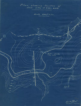
Plan showing locations of dam sites at Green Lake
Part of City of Vancouver fonds
![Miscellaneous [60 of 130]](/uploads/r/null/9/e/9ed32a03560d6a3a2c68861822f9fd15db32eb1d7bb2dddb194adba406842fce/583e7e72-0708-4d02-a88a-cd4a1a78ddc4-A64391_142.jpg)
Part of City of Vancouver fonds
Fraser River and Burrard Inlet
Part of City of Vancouver Archives technical and cartographic drawing collection
![Profile of Lillooet River between Lillooet & Tenasse [Tenas] Lake](/uploads/r/null/7/b/8/7b86c7530348c631fba136d04e4b31b414065b7e3f90c8000f45b0b3cc1242c8/bfb1c164-5e71-45ae-add4-e17ffd8c8272-MAP1140_142.jpg)
Profile of Lillooet River between Lillooet & Tenasse [Tenas] Lake
Part of City of Vancouver fonds
Proposed hydro-electric power development on Cheakamus River
Part of City of Vancouver fonds

Profile dam no. 2 Soo River at 4+4980
Part of City of Vancouver fonds

Plan showing the Brunette Saw Mill Co's timber claims "B" and "C" on upper Pitt River
Part of City of Vancouver fonds
Item is a map of a portion of the Pitt River and surrounding area. The map shows bodies of water, elevations and terrain information, as well as a traverse table for each claim.