
Burrard Inlet - Vancouver sheet
- AM1594-MAP 1157-: LEG1153.055
- Item
- 1921
Part of City of Vancouver Archives technical and cartographic drawing collection
14 results with digital objects Show results with digital objects
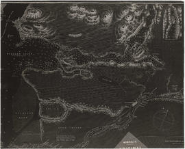
Burrard Inlet - Vancouver sheet
Part of City of Vancouver Archives technical and cartographic drawing collection

Burrard Inlet - Dollarton sheet
Part of City of Vancouver Archives technical and cartographic drawing collection

Burrard Inlet - Second Narrows sheet
Part of City of Vancouver Archives technical and cartographic drawing collection

Part of City of Vancouver Archives technical and cartographic drawing collection

Burrard Inlet - Port Moody sheet
Part of City of Vancouver Archives technical and cartographic drawing collection

Burrard Inlet - triangulation control
Part of City of Vancouver Archives technical and cartographic drawing collection

North America. West Coast. Fraser River and Burrard Inlet
Part of City of Vancouver Archives technical and cartographic drawing collection
Item is a nautical chart which show details of area surveyed from Pitt Lake in the north to Roberts Bank in the south and from (what is now) Harrison Hot Springs in the east to Bowen Island in the west. The chart shows soundings in Burrard Inlet, and along the Fraser River.

Part of City of Vancouver Archives technical and cartographic drawing collection
Item is a photostat copy of a portion of a map of Burrard Inlet from the 1859 H.M.S. Plumper Survey. The map depicts outer Burrard Inlet and the surrounding shorlines.

Part of City of Vancouver Archives technical and cartographic drawing collection
Item is a copy of a portion of a British Admiralty hydrographic survey of Burrard Inlet. The copied portion shows the area from First Narrows to just east of Capital Hill. The map shows soundings in the Inlet, as well as indications of topography of the surrounding shoreline areas.

Part of Major Matthews collection
Item is a copy of a portion of a manuscript map of Burrard Inlet, created during the H.M.S. Plumper survey of the area. Sheet shows the eastern portion of the Inlet, including the southern portion of the North Arm.
United Kingdom. Admiralty

Fraser River and Burrard Inlet
Part of Major Matthews collection

Fraser River and Burrard Inlet
Part of Major Matthews collection
Fraser River and Burrard Inlet
Part of Major Matthews collection

North America. West Coast. Fraser River and Burrard Inlet
Part of City of Vancouver Archives technical and cartographic drawing collection
Item is a nautical chart which show details of area surveyed from Pitt Lake in the north to Roberts Bank in the south and from (what is now) Harrison Hot Springs in the east to Bowen Island in the west. The chart shows soundings in Burrard Inlet, and along the Fraser River.