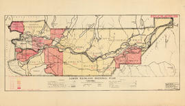
Lower Mainland Regional Plan : population distribution
- AM683-S5---: LEG1349.02
- Item
- Sept. 1, 1945
Part of Community Planning Association of Canada, British Columbia Division fonds
6 results with digital objects Show results with digital objects
Lower Mainland Regional Plan : population distribution
Part of Community Planning Association of Canada, British Columbia Division fonds
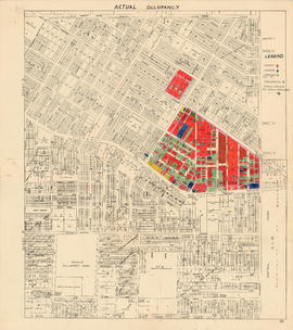
Actual occupancy : area bounded by Joyce Street, Boundary Road, Wellington Avenue and Kingsway
Part of City of Vancouver fonds

City of Vancouver : households and population by enumeration areas : 1961 census
Part of City of Vancouver fonds
Item is a map annotated to show census tract numbers and boundaries, enumeration area boundaries, and households and pooulation within enumeration areas. Other numbers are hand-written on some of the areas, but the meaning of these numbers is unknown. Base map shows streets, parks, and golf courses.

Map showing location of single men receiving assistance by mail
Part of City of Vancouver Archives technical and cartographic drawing collection
Item is a map showing the City of Vancouver covered with annotations to represent the numbers of men in particular areas receiving assistance by mail. Map is a copy of the original and it is not possible to determine the original colour coding.
Vancouver (B.C.). Engineering Services

Map showing location of single women receiving assistance by mail
Part of City of Vancouver Archives technical and cartographic drawing collection
Item is a map showing the City of Vancouver covered with annotations to represent the numbers of women in particular areas receiving assistance by mail. Map is a copy of the original and it is not possible to determine the original colour coding.
Vancouver (B.C.). Engineering Services

City and District of North Vancouver
Part of City of Vancouver Archives technical and cartographic drawing collection
Item is a map showing the city and district of North Vancouver. It shows paved roads, gravel roads, unopened roads and a graphical depiction of the population as of 1947. A small inset map shows the position of the city of North Vancouver and the district of North Vancouver in relation to Vancouver, Burrard Inlet and West Vancouver. Annotations appear to be in J.S. Matthews' hand, noting a portion of North Vancouver as "King's Lynn".
Vancouver, British Columbia : [urban analysis maps]
Part of City of Vancouver Archives technical and cartographic drawing collection
Maps show land use, land slope and elevation, density of buildings, structural material of buildings, height of buildings, water supply systems, sewage systems, electric power systems, gas trunk systems, population distribution, daytime population distribution, dwelling units, schools, hospitals and doctors, land transportation, port facilities, food manufacturing, textile manufacturing, wood product manufacturing, metal product manufacturing, transportation equipment manufacturing, non-metallic mineral and chemical products manufacturing, retail and wholesale food enterprises, retail and wholesale building materials enterprises, retail and wholesale drugs, general merchandise, apparel and accessories enterprises, retail and wholesale clothing and shoes enterprises, retail and wholesale furnishing enterprises and hotels and eating places in the Greater Vancouver area (including West Vancouver, North Vancouver, Vancouver, Burnaby, New Westminster, the northern portion of Richmond and the western portion of Coquitlam). Much of the data for these maps was derived from the 1961 census of Canada.
The development of a profile : a century of population growth in British Columbia
Item is a paper by J.T. Marshall, Assistant Dominion Statistician, Dominion Bureau of Statistics, presented at the 46th annual meeting of the Canadian Public Health Association.
The province [Canadian Habitat Secretariat article "My Prayer, my hope, my dream"]
The world is a ship and everyone's in steerage [Canadian Habitat Secretariat]
Part of City of Vancouver Archives technical and cartographic drawing collection
Map shows Vancouver, North Vancouver, New Westminster and Burnaby. Municipal boundaries, census boundaries and population numbers are identified.
Map of Vancouver Unemployment and Relief [BC]
Part of City of Vancouver Archives technical and cartographic drawing collection
The map shows relief and elevations of Vancouver. It depicts streets, parks, and railways, and residential and industrial areas.
The annotations in black ink trace parts of the map: names, railways, and the coast line. The amendments also show Cases and Persons of Domiciled Residents in the Vancouver Area, in May 1934. The map also lists statistics of approximate Cases and Persons of Transient Families and Single Women, and Single Homeless Men.
Pensions and Compensation statistics are also compiled for: Mothers Pensions, Old Age Pensions, War Pensions, amd Workmen's Compensation as of the population of Vancouver in 1931.
The westernmost boundary of the map is Boundary Road and the easternmost boundary is the University of British Columbia while the northernmost is the Burrard Inlet and the southernmost is Sea Island and Lulu Island.