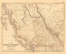
Showing 2 results

Archival description
City of Vancouver Archives technical and cartographic drawing collection British Columbia Geography With digital objects
Print preview View:

Map of British Columbia

Item is an administrative map which show the locations of government offices, including: mining recording offices, trading posts, E. & N. Ry. land grants, railways, and highways. Text includes: Adminstration lists (e.g. Supreme Court County Courts, radio stations, Customs and Excise, index of post offices, etc.); Distance tables [for coast, roads, railways, world]; The population of city, district and village municipalities in British Columbia [from the] census, 1931. Map also includes an inset detailing the Strait of Georgia between Victoria and Vancouver.